The SY3 8 postcode sector is within the county of Shropshire.
Did you know? According to the 2021 Census, the SY3 8 postcode sector is home to a bustling 9,246 residents!
Given that each sector allows for 400 unique postcode combinations. Letters C, I, K, M, O and V are not allowed in the last two letters of a postcode. With 297 postcodes already in use, this leaves 103 units available.
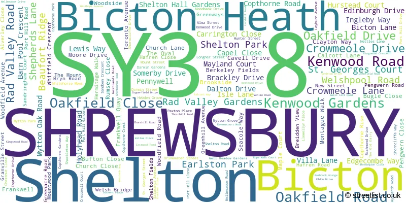
The largest settlement in the SY3 8 postal code is SHREWSBURY followed by Bicton, and Bicton Heath.
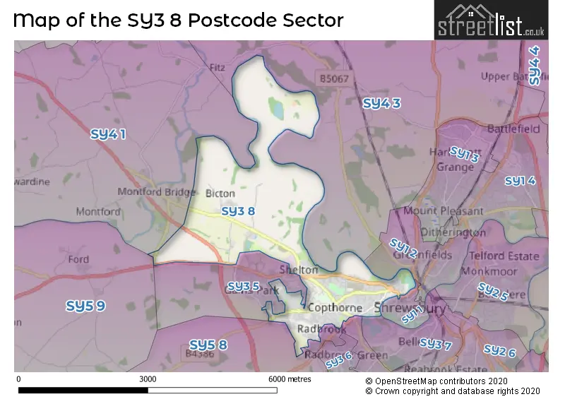
The SY3 8 Postcode shares a border with SY4 1 (Montford Bridge, Ruyton XI Towns, Nesscliffe), SY4 3 (Bomere Heath, Harmer Hill, Myddle), SY1 1 (SHREWSBURY), SY3 5 (Bicton Heath, SHREWSBURY, Bowbrook), SY5 8 (Hanwood, Bowbrook, Longden), SY1 2 (SHREWSBURY), SY3 7 (SHREWSBURY), SY3 9 (SHREWSBURY, Meole Brace) and SY5 9 (Westbury, Ford, Halfway House).
The sector is within the post town of SHREWSBURY.
SY3 8 is a postcode sector within the SY3 postcode district which is within the SY Shrewsbury postcode area.
The Royal Mail delivery office for the SY3 8 postal sector is the Shrewsbury Delivery Office.
The area of the SY3 8 postcode sector is 5.25 square miles which is 13.59 square kilometres or 3,359.39 square acres.

Map of the SY3 8 Postcode Sector
Explore the SY3 8 postcode sector by using our free interactive map.
| S | Y | 3 | - | 8 | X | X |
| S | Y | 3 | Space | 8 | Letter | Letter |
Official List of Streets
SHREWSBURY (122 Streets)
Shelton (4 Streets)
Bicton (12 Streets)
Bicton Heath (3 Streets)
Unofficial Streets or Alternative Spellings
SHREWSBURY
HURSTEAD COURT MAYLAND COURT RADBROOK ROAD ROPE WALK COURT SANDIWAY VICTORIA AVENUE WOODSIDE DRIVEBicton Heath
GAINS PARK WAY KEELTON CLOSE LEIGHTON PARK OAK LANE OLIVER ROAD RACECOURSE LANE THE FURLONGSBowbrook
HARPERS MEADOW MAITHEN CRESCENT MEADOWBOUT WAY MYTTON OAK ROADWeather Forecast for SY3 8
Press Button to Show Forecast for Preston Montford
| Time Period | Icon | Description | Temperature | Rain Probability | Wind |
|---|---|---|---|---|---|
| 18:00 to 21:00 | Cloudy | 8.0°C (feels like 7.0°C) | 11.00% | NE 7 mph | |
| 21:00 to 00:00 | Cloudy | 6.0°C (feels like 4.0°C) | 11.00% | ENE 7 mph |
Press Button to Show Forecast for Preston Montford
| Time Period | Icon | Description | Temperature | Rain Probability | Wind |
|---|---|---|---|---|---|
| 00:00 to 03:00 | Cloudy | 5.0°C (feels like 3.0°C) | 11.00% | ENE 7 mph | |
| 03:00 to 06:00 | Cloudy | 5.0°C (feels like 3.0°C) | 13.00% | ENE 7 mph | |
| 06:00 to 09:00 | Cloudy | 5.0°C (feels like 3.0°C) | 13.00% | ENE 7 mph | |
| 09:00 to 12:00 | Cloudy | 8.0°C (feels like 5.0°C) | 18.00% | ENE 9 mph | |
| 12:00 to 15:00 | Overcast | 9.0°C (feels like 7.0°C) | 19.00% | ENE 9 mph | |
| 15:00 to 18:00 | Overcast | 9.0°C (feels like 6.0°C) | 18.00% | ENE 9 mph | |
| 18:00 to 21:00 | Overcast | 8.0°C (feels like 6.0°C) | 16.00% | NE 7 mph | |
| 21:00 to 00:00 | Cloudy | 7.0°C (feels like 4.0°C) | 7.00% | NE 7 mph |
Press Button to Show Forecast for Preston Montford
| Time Period | Icon | Description | Temperature | Rain Probability | Wind |
|---|---|---|---|---|---|
| 00:00 to 03:00 | Cloudy | 5.0°C (feels like 3.0°C) | 8.00% | NNE 7 mph | |
| 03:00 to 06:00 | Cloudy | 5.0°C (feels like 2.0°C) | 11.00% | N 9 mph | |
| 06:00 to 09:00 | Cloudy | 5.0°C (feels like 2.0°C) | 14.00% | NNW 9 mph | |
| 09:00 to 12:00 | Cloudy | 7.0°C (feels like 4.0°C) | 14.00% | NNW 11 mph | |
| 12:00 to 15:00 | Overcast | 10.0°C (feels like 7.0°C) | 17.00% | NW 11 mph | |
| 15:00 to 18:00 | Cloudy | 11.0°C (feels like 9.0°C) | 10.00% | NW 9 mph | |
| 18:00 to 21:00 | Sunny day | 10.0°C (feels like 8.0°C) | 3.00% | W 9 mph | |
| 21:00 to 00:00 | Clear night | 6.0°C (feels like 3.0°C) | 1.00% | SW 7 mph |
Press Button to Show Forecast for Preston Montford
| Time Period | Icon | Description | Temperature | Rain Probability | Wind |
|---|---|---|---|---|---|
| 00:00 to 03:00 | Clear night | 5.0°C (feels like 2.0°C) | 1.00% | SSW 7 mph | |
| 03:00 to 06:00 | Partly cloudy (night) | 4.0°C (feels like 2.0°C) | 1.00% | S 7 mph | |
| 06:00 to 09:00 | Sunny day | 6.0°C (feels like 3.0°C) | 1.00% | SSE 9 mph | |
| 09:00 to 12:00 | Partly cloudy (day) | 11.0°C (feels like 8.0°C) | 1.00% | S 13 mph | |
| 12:00 to 15:00 | Cloudy | 13.0°C (feels like 10.0°C) | 6.00% | S 16 mph | |
| 15:00 to 18:00 | Cloudy | 13.0°C (feels like 10.0°C) | 7.00% | S 16 mph | |
| 18:00 to 21:00 | Partly cloudy (day) | 12.0°C (feels like 10.0°C) | 5.00% | S 13 mph | |
| 21:00 to 00:00 | Partly cloudy (night) | 9.0°C (feels like 7.0°C) | 2.00% | SSE 11 mph |
Press Button to Show Forecast for Preston Montford
| Time Period | Icon | Description | Temperature | Rain Probability | Wind |
|---|---|---|---|---|---|
| 00:00 to 03:00 | Partly cloudy (night) | 8.0°C (feels like 5.0°C) | 2.00% | SE 11 mph | |
| 03:00 to 06:00 | Cloudy | 7.0°C (feels like 5.0°C) | 4.00% | SE 9 mph | |
| 06:00 to 09:00 | Sunny day | 8.0°C (feels like 6.0°C) | 3.00% | ESE 9 mph | |
| 09:00 to 12:00 | Sunny day | 12.0°C (feels like 10.0°C) | 4.00% | SE 13 mph | |
| 12:00 to 15:00 | Cloudy | 15.0°C (feels like 12.0°C) | 11.00% | SE 13 mph | |
| 15:00 to 18:00 | Partly cloudy (day) | 15.0°C (feels like 13.0°C) | 12.00% | SE 11 mph | |
| 18:00 to 21:00 | Cloudy | 14.0°C (feels like 12.0°C) | 11.00% | SE 9 mph | |
| 21:00 to 00:00 | Partly cloudy (night) | 11.0°C (feels like 9.0°C) | 4.00% | ESE 7 mph |
Schools and Places of Education Within the SY3 8 Postcode Sector
Bicton CofE Primary School and Nursery
Voluntary controlled school
Bicton Lane, Shrewsbury, Shropshire, SY3 8EH
Head: Mrs Natalie Johnson
Ofsted Rating: Requires improvement
Inspection: 2021-09-22 (947 days ago)
Website: Visit Bicton CofE Primary School and Nursery Website
Phone: 01743850212
Number of Pupils: 151
St George's Junior School
Academy converter
Woodfield Road, Shrewsbury, Shropshire, SY3 8LU
Head: Mrs Kelly Lee
Ofsted Rating: Good
Inspection: 2023-02-09 (442 days ago)
Website: Visit St George's Junior School Website
Phone: 01743357133
Number of Pupils: 352
House Prices in the SY3 8 Postcode Sector
| Type of Property | 2018 Average | 2018 Sales | 2017 Average | 2017 Sales | 2016 Average | 2016 Sales | 2015 Average | 2015 Sales |
|---|---|---|---|---|---|---|---|---|
| Detached | £381,105 | 74 | £369,666 | 65 | £390,144 | 71 | £329,628 | 92 |
| Semi-Detached | £253,893 | 60 | £275,892 | 68 | £256,358 | 56 | £243,671 | 77 |
| Terraced | £167,864 | 22 | £187,828 | 29 | £177,812 | 31 | £151,390 | 37 |
| Flats | £120,288 | 20 | £122,768 | 22 | £136,625 | 47 | £174,341 | 48 |
Important Postcodes SY3 8 in the Postcode Sector
SY3 8BB is the postcode for Environment Agency, Hafren House, Welshpool Road
SY3 8DN is the postcode for South Staffordshire and Shropshire Healthcare NHS Foundation Trust, Shelton Hospital
SY3 8DS is the postcode for CARADOC BUILDING, The Redwood Centre, Somerby Drive, WREKIN BUILDING, The Redwood Centre, Somerby Drive, CLEE BUILDING, The Redwood Centre, Somerby Drive, and WENLOCK BUILDING, The Redwood Centre, Somerby Drive
SY3 8EH is the postcode for Bicton C E Primary School, Bicton Lane, Bicton, and Bicton C E Primary School, Bicton Lane
SY3 8FT is the postcode for Theatre Severn, Frankwell Quay
SY3 8HB is the postcode for The Guildhall, Frankwell Quay
SY3 8HQ is the postcode for Shrewsbury & Atcham Borough Council, The Guildhall, Frankwell Quay
SY3 8HS is the postcode for Severn Hospice Ltd, Bicton Heath
SY3 8LU is the postcode for St. Georges Junior School, Woodfield Road, and Woodfield Infant School, Woodfield Road
SY3 8LZ is the postcode for BUILDING 1, Ministry of Defence, Post Room HQ (W M) B D E, 143 Copthorne Road, Copthorne Barracks
SY3 8PU is the postcode for Valuation Office Agency, Darwin House, 2 The Mount
SY3 8XL is the postcode for Building 06 Oak Lodge, Shropshire County Primary Care Trust, William Farr House, Block 9 Somerby Suite, Shropshire County Primary Care Trust, William Farr House, Shropshire County Primary Care Trust, William Farr House, Mytton Oak Road, Block 3 Partnership House, Shropshire County Primary Care Trust, William Farr House, Building 02, Therapy Services Building, Mytton Oak Road, Building 08 Poplar Suite, Shropshire County Primary Care Trust, William Farr House, and Main Building, Shropshire County Primary Care Trust, William Farr House
SY3 8XQ is the postcode for STRETTON HOUSE, Shrewsbury And Telford Hospital NHS Trust, Royal Shrewsbury Hospital North, Shrewsbury And Telford Hospital NHS Trust, Royal Shrewsbury Hospital North, LEARNING CENTRE, Shrewsbury And Telford Hospital NHS Trust, Royal Shrewsbury Hospital North, ESTATES DEPARTMENT, Shrewsbury And Telford Hospital NHS Trust, Royal Shrewsbury Hospital North, HAMAR CENTRE, Shrewsbury And Telford Hospital NHS Trust, Royal Shrewsbury Hospital North, UGMS & SCHOOL OF HEALTH, Shrewsbury And Telford Hospital NHS Trust, Royal Shrewsbury Hospital North, Shrewsbury And Telford Hospital NHS Trust, Royal Shrewsbury Hospital North, Mytton Oak Road, MYTTON OAK UNIT, ROYAL SHREWSBURY HOSPITAL NORTH, MYTTON OAK ROAD, and MYTTON OAK CENTRE, Royal Shrewsbury Hospital North, Mytton Oak Road
| The SY3 8 Sector is within these Local Authorities |
|
|---|---|
| The SY3 8 Sector is within these Counties |
|
| The SY3 8 Sector is within these Water Company Areas |
|