The SY4 2 postcode sector is within the county of Shropshire.
Did you know? According to the 2021 Census, the SY4 2 postcode sector is home to a bustling 3,252 residents!
Given that each sector allows for 400 unique postcode combinations. Letters C, I, K, M, O and V are not allowed in the last two letters of a postcode. With 139 postcodes already in use, this leaves 261 units available.
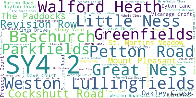
The largest settlement in the SY4 2 postal code is Baschurch followed by Little Ness, and Weston Lullingfields.
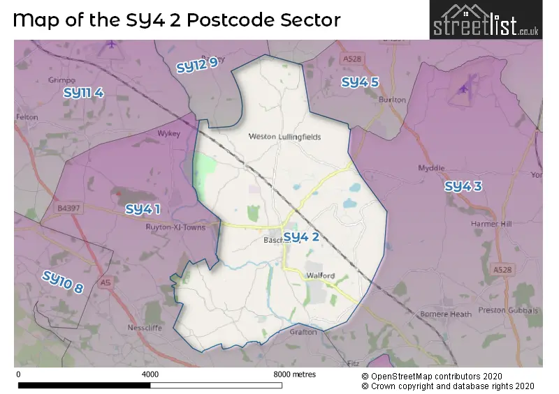
The SY4 2 Postcode shares a border with SY4 1 (Montford Bridge, Ruyton XI Towns, Nesscliffe), SY4 3 (Bomere Heath, Harmer Hill, Myddle), SY4 5 (Wem, Burlton, Weston), SY12 0 (ELLESMERE, Cockshutt, Welshampton) and SY12 9 (ELLESMERE, Dudleston Heath, Dudleston).
The sector is within the post town of SHREWSBURY.
SY4 2 is a postcode sector within the SY4 postcode district which is within the SY Shrewsbury postcode area.
The Royal Mail delivery office for the SY4 2 postal sector is the Shrewsbury Delivery Office.
The area of the SY4 2 postcode sector is 14.65 square miles which is 37.94 square kilometres or 9,375.09 square acres.

Map of the SY4 2 Postcode Sector
Explore the SY4 2 postcode sector by using our free interactive map.
| S | Y | 4 | - | 2 | X | X |
| S | Y | 4 | Space | 2 | Letter | Letter |
Official List of Streets
Baschurch (50 Streets)
Weston Lullingfields (11 Streets)
Little Ness (3 Streets)
Walford Heath (1 Streets)
Unofficial Streets or Alternative Spellings
SHREWSBURY
BERWICK ROAD DAKIN DRIVE FIRS CLOSE LITTLE NESS NEWTOWN PEA LANE SALT CRESCENT SHREWSBURY ROAD THE MEADOWS VALESWOOD LANE VICTORIA VILLAS WHITMORE LANEMontford Bridge
RODEFERN LANERuyton XI Towns
LITTLE NESS ROAD THE CLIFFEWeather Forecast for SY4 2
Press Button to Show Forecast for Wilcott
| Time Period | Icon | Description | Temperature | Rain Probability | Wind |
|---|---|---|---|---|---|
| 00:00 to 03:00 | Cloudy | 5.0°C (feels like 3.0°C) | 11.00% | ENE 7 mph | |
| 03:00 to 06:00 | Cloudy | 5.0°C (feels like 3.0°C) | 12.00% | ENE 7 mph | |
| 06:00 to 09:00 | Cloudy | 5.0°C (feels like 3.0°C) | 11.00% | NE 7 mph | |
| 09:00 to 12:00 | Cloudy | 8.0°C (feels like 5.0°C) | 16.00% | ENE 9 mph | |
| 12:00 to 15:00 | Overcast | 9.0°C (feels like 7.0°C) | 22.00% | NE 7 mph | |
| 15:00 to 18:00 | Overcast | 9.0°C (feels like 6.0°C) | 47.00% | NE 9 mph | |
| 18:00 to 21:00 | Overcast | 8.0°C (feels like 6.0°C) | 13.00% | NE 7 mph | |
| 21:00 to 00:00 | Cloudy | 7.0°C (feels like 4.0°C) | 8.00% | NE 7 mph |
Press Button to Show Forecast for Wilcott
| Time Period | Icon | Description | Temperature | Rain Probability | Wind |
|---|---|---|---|---|---|
| 00:00 to 03:00 | Cloudy | 5.0°C (feels like 3.0°C) | 8.00% | NNE 7 mph | |
| 03:00 to 06:00 | Cloudy | 5.0°C (feels like 2.0°C) | 10.00% | N 9 mph | |
| 06:00 to 09:00 | Cloudy | 5.0°C (feels like 2.0°C) | 15.00% | NNW 9 mph | |
| 09:00 to 12:00 | Cloudy | 7.0°C (feels like 4.0°C) | 14.00% | NNW 9 mph | |
| 12:00 to 15:00 | Overcast | 10.0°C (feels like 8.0°C) | 17.00% | NW 11 mph | |
| 15:00 to 18:00 | Cloudy | 11.0°C (feels like 9.0°C) | 10.00% | NW 11 mph | |
| 18:00 to 21:00 | Sunny day | 10.0°C (feels like 8.0°C) | 3.00% | W 9 mph | |
| 21:00 to 00:00 | Clear night | 5.0°C (feels like 3.0°C) | 1.00% | SW 7 mph |
Press Button to Show Forecast for Wilcott
| Time Period | Icon | Description | Temperature | Rain Probability | Wind |
|---|---|---|---|---|---|
| 00:00 to 03:00 | Clear night | 5.0°C (feels like 2.0°C) | 1.00% | SSW 7 mph | |
| 03:00 to 06:00 | Cloudy | 4.0°C (feels like 1.0°C) | 4.00% | S 7 mph | |
| 06:00 to 09:00 | Sunny day | 6.0°C (feels like 3.0°C) | 1.00% | SSE 9 mph | |
| 09:00 to 12:00 | Partly cloudy (day) | 11.0°C (feels like 8.0°C) | 1.00% | S 13 mph | |
| 12:00 to 15:00 | Cloudy | 13.0°C (feels like 10.0°C) | 6.00% | S 16 mph | |
| 15:00 to 18:00 | Cloudy | 13.0°C (feels like 10.0°C) | 7.00% | S 16 mph | |
| 18:00 to 21:00 | Cloudy | 12.0°C (feels like 10.0°C) | 7.00% | S 13 mph | |
| 21:00 to 00:00 | Partly cloudy (night) | 9.0°C (feels like 7.0°C) | 2.00% | SSE 11 mph |
Press Button to Show Forecast for Wilcott
| Time Period | Icon | Description | Temperature | Rain Probability | Wind |
|---|---|---|---|---|---|
| 00:00 to 03:00 | Partly cloudy (night) | 8.0°C (feels like 5.0°C) | 2.00% | SE 11 mph | |
| 03:00 to 06:00 | Cloudy | 7.0°C (feels like 5.0°C) | 4.00% | SE 9 mph | |
| 06:00 to 09:00 | Sunny day | 8.0°C (feels like 6.0°C) | 3.00% | ESE 9 mph | |
| 09:00 to 12:00 | Sunny day | 12.0°C (feels like 10.0°C) | 4.00% | SE 13 mph | |
| 12:00 to 15:00 | Cloudy | 15.0°C (feels like 12.0°C) | 11.00% | SE 13 mph | |
| 15:00 to 18:00 | Partly cloudy (day) | 15.0°C (feels like 13.0°C) | 12.00% | SE 11 mph | |
| 18:00 to 21:00 | Cloudy | 14.0°C (feels like 12.0°C) | 11.00% | SE 9 mph | |
| 21:00 to 00:00 | Partly cloudy (night) | 10.0°C (feels like 9.0°C) | 4.00% | ESE 7 mph |
Schools and Places of Education Within the SY4 2 Postcode Sector
Baschurch CofE Primary School
Voluntary aided school
Eyton Lane, Shrewsbury, Shropshire, SY4 2AU
Head: Mrs Clare Williams
Ofsted Rating: Good
Inspection: 2023-05-18 (345 days ago)
Website: Visit Baschurch CofE Primary School Website
Phone: 01939260443
Number of Pupils: 204
The Corbet School
Academy converter
Eyton Lane, Shrewsbury, Shropshire, SY4 2AX
Head: Dr Jane Tinker
Ofsted Rating: Good
Inspection: 2022-03-30 (759 days ago)
Website: Visit The Corbet School Website
Phone: 01939260296
Number of Pupils: 733
Weston Lullingfields CofE School
Foundation school
Weston Lullingfields, Shrewsbury, Shropshire, SY4 2AW
Head: Mrs Kate Scott
Ofsted Rating: Requires improvement
Inspection: 2023-01-18 (465 days ago)
Website: Visit Weston Lullingfields CofE School Website
Phone: 01939260306
Number of Pupils: 33
House Prices in the SY4 2 Postcode Sector
| Type of Property | 2018 Average | 2018 Sales | 2017 Average | 2017 Sales | 2016 Average | 2016 Sales | 2015 Average | 2015 Sales |
|---|---|---|---|---|---|---|---|---|
| Detached | £348,152 | 52 | £306,581 | 61 | £290,615 | 48 | £325,859 | 34 |
| Semi-Detached | £191,377 | 13 | £189,109 | 35 | £212,682 | 11 | £170,189 | 5 |
| Terraced | £227,400 | 5 | £161,944 | 9 | £256,250 | 2 | £184,550 | 10 |
| Flats | £310,000 | 1 | £0 | 0 | £0 | 0 | £0 | 0 |
Important Postcodes SY4 2 in the Postcode Sector
SY4 2AU is the postcode for Baschurch C of E (Aided) Primary School, Eyton Lane, Baschurch, and Baschurch C of E (Aided) Primary School, Eyton Lane
SY4 2AX is the postcode for BLOCK 1, The Corbet School, Eyton Lane, BLOCK 1, The Corbet School Academy, Eyton Lane, SCIENCE BLOCK, The Corbet School, Eyton Lane, BLOCK 6 SPORTS HALL, The Corbet School, Eyton Lane, BLOCK 3, The Corbet School, Eyton Lane, BLOCK 4, The Corbet School Academy, Eyton Lane, BLOCK 2, The Corbet School, Eyton Lane, BLOCK 4, The Corbet School, Eyton Lane, and The Corbet School, Eyton Lane
SY4 2DR is the postcode for Prescott Surgery, Prescott Road
SY4 2HL is the postcode for North Shropshire College, Walford Hall,, COLLINS, North Shropshire College, Walford Hall,, HARRIS BUILDING, North Shropshire College, Walford Hall,, BREIDDEN, North Shropshire College, Walford Hall,, Motor Vehicle Unit, North Shropshire College, Walford Hall,, SPORTS CENTRE, North Shropshire College, Walford Hall,, ENGINEERING UNIT, North Shropshire College, Walford Hall,, MAIN TEACHING BLOCK, North Shropshire College, Walford Hall,, TRACTOR WORKSHOP, North Shropshire College, Walford Hall,, STABLE BUILDING, North Shropshire College, Walford Hall,, and SOCIAL CLUB, North Shropshire College, Walford Hall,
SY4 2JA is the postcode for Greenacres Rural Training Centre, Fenemere Lane, Fenemere
| The SY4 2 Sector is within these Local Authorities |
|
|---|---|
| The SY4 2 Sector is within these Counties |
|
| The SY4 2 Sector is within these Water Company Areas |
|