The TN35 4 postcode sector is within the county of East Sussex.
Did you know? According to the 2021 Census, the TN35 4 postcode sector is home to a bustling 7,417 residents!
Given that each sector allows for 400 unique postcode combinations. Letters C, I, K, M, O and V are not allowed in the last two letters of a postcode. With 208 postcodes already in use, this leaves 192 units available.
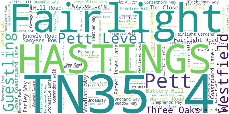
The largest settlement in the TN35 4 postal code is HASTINGS followed by Westfield, and Fairlight.
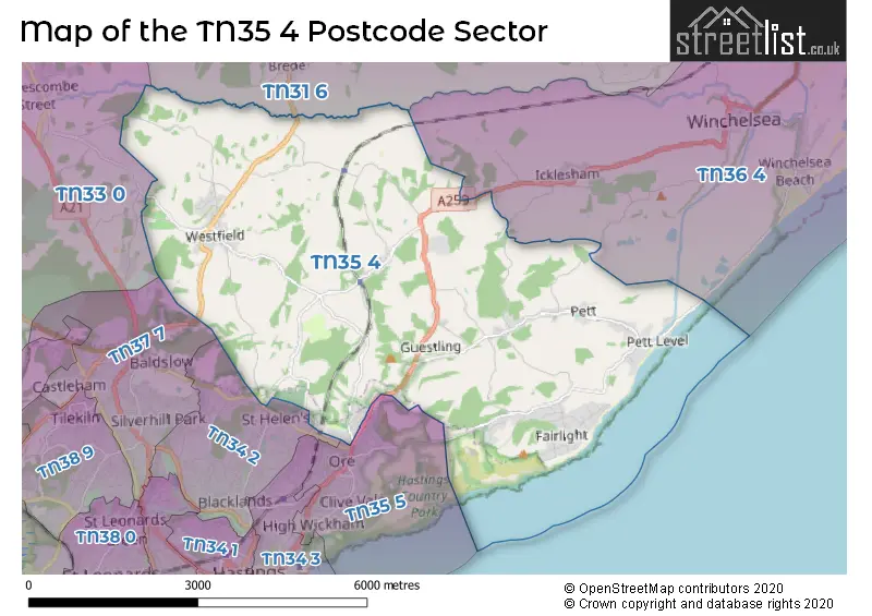
The TN35 4 Postcode shares a border with TN31 6 (Northiam, Peasmarsh, Beckley), TN33 0 (BATTLE, Sedlescombe, Whatlington), TN34 2 (HASTINGS), TN35 5 (HASTINGS), TN36 4 (Winchelsea Beach, Icklesham, WINCHELSEA) and TN37 7 (ST. LEONARDS-ON-SEA).
The sector is within the post town of HASTINGS.
TN35 4 is a postcode sector within the TN35 postcode district which is within the TN Tonbridge postcode area.
The Royal Mail delivery office for the TN35 4 postal sector is the Hastings Delivery Office.
The area of the TN35 4 postcode sector is 15.55 square miles which is 40.27 square kilometres or 9,949.71 square acres.
The TN35 4 postcode sector is crossed by the A259 Major A road.
Waterways within the TN35 4 postcode sector include the Pannel Sewer, Brede, Marsham Sewer.

Map of the TN35 4 Postcode Sector
Explore the TN35 4 postcode sector by using our free interactive map.
| T | N | 3 | 5 | - | 4 | X | X |
| T | N | 3 | 5 | Space | 4 | Letter | Letter |
Official List of Streets
Guestling (14 Streets)
Pett (8 Streets)
HASTINGS (29 Streets)
Fairlight (34 Streets)
Westfield (30 Streets)
Three Oaks (6 Streets)
Unofficial Streets or Alternative Spellings
Icklesham
MAIN ROAD WATERMILL LANEHASTINGS
MARTINEAU LANEHASTINGS,
THE RIDGESedlescombe
COTTAGE LANEWeather Forecast for TN35 4
Press Button to Show Forecast for Hastings Youth Hostel
| Time Period | Icon | Description | Temperature | Rain Probability | Wind |
|---|---|---|---|---|---|
| 12:00 to 15:00 | Cloudy | 11.0°C (feels like 9.0°C) | 48.00% | SE 9 mph | |
| 15:00 to 18:00 | Heavy rain | 10.0°C (feels like 9.0°C) | 88.00% | NE 4 mph | |
| 18:00 to 21:00 | Heavy rain | 9.0°C (feels like 7.0°C) | 95.00% | NE 9 mph | |
| 21:00 to 00:00 | Heavy rain | 10.0°C (feels like 8.0°C) | 92.00% | ENE 11 mph |
Press Button to Show Forecast for Hastings Youth Hostel
| Time Period | Icon | Description | Temperature | Rain Probability | Wind |
|---|---|---|---|---|---|
| 00:00 to 03:00 | Heavy rain | 10.0°C (feels like 9.0°C) | 80.00% | ESE 9 mph | |
| 03:00 to 06:00 | Cloudy | 10.0°C (feels like 8.0°C) | 44.00% | S 13 mph | |
| 06:00 to 09:00 | Heavy rain | 10.0°C (feels like 7.0°C) | 80.00% | S 13 mph | |
| 09:00 to 12:00 | Cloudy | 11.0°C (feels like 8.0°C) | 12.00% | SSW 16 mph | |
| 12:00 to 15:00 | Light rain | 9.0°C (feels like 5.0°C) | 49.00% | WSW 20 mph | |
| 15:00 to 18:00 | Overcast | 9.0°C (feels like 6.0°C) | 12.00% | WSW 16 mph | |
| 18:00 to 21:00 | Partly cloudy (day) | 10.0°C (feels like 7.0°C) | 4.00% | SW 11 mph | |
| 21:00 to 00:00 | Clear night | 8.0°C (feels like 6.0°C) | 0.00% | SSW 9 mph |
Press Button to Show Forecast for Hastings Youth Hostel
| Time Period | Icon | Description | Temperature | Rain Probability | Wind |
|---|---|---|---|---|---|
| 00:00 to 03:00 | Clear night | 8.0°C (feels like 6.0°C) | 0.00% | SW 9 mph | |
| 03:00 to 06:00 | Clear night | 7.0°C (feels like 5.0°C) | 0.00% | SW 7 mph | |
| 06:00 to 09:00 | Sunny day | 9.0°C (feels like 7.0°C) | 0.00% | SSW 7 mph | |
| 09:00 to 12:00 | Sunny day | 11.0°C (feels like 9.0°C) | 0.00% | SSW 11 mph | |
| 12:00 to 15:00 | Sunny day | 13.0°C (feels like 10.0°C) | 2.00% | S 13 mph | |
| 15:00 to 18:00 | Sunny day | 13.0°C (feels like 11.0°C) | 2.00% | SSW 11 mph | |
| 18:00 to 21:00 | Sunny day | 12.0°C (feels like 11.0°C) | 1.00% | S 4 mph | |
| 21:00 to 00:00 | Clear night | 8.0°C (feels like 6.0°C) | 1.00% | ESE 7 mph |
Press Button to Show Forecast for Hastings Youth Hostel
| Time Period | Icon | Description | Temperature | Rain Probability | Wind |
|---|---|---|---|---|---|
| 00:00 to 03:00 | Clear night | 8.0°C (feels like 6.0°C) | 1.00% | ESE 7 mph | |
| 03:00 to 06:00 | Partly cloudy (night) | 9.0°C (feels like 7.0°C) | 1.00% | SE 7 mph | |
| 06:00 to 09:00 | Cloudy | 10.0°C (feels like 8.0°C) | 5.00% | SE 9 mph | |
| 09:00 to 12:00 | Overcast | 12.0°C (feels like 11.0°C) | 12.00% | SE 9 mph | |
| 12:00 to 15:00 | Light rain shower (day) | 14.0°C (feels like 12.0°C) | 33.00% | SE 11 mph | |
| 15:00 to 18:00 | Cloudy | 14.0°C (feels like 12.0°C) | 13.00% | SE 9 mph | |
| 18:00 to 21:00 | Cloudy | 14.0°C (feels like 12.0°C) | 14.00% | SE 7 mph | |
| 21:00 to 00:00 | Light rain | 11.0°C (feels like 10.0°C) | 46.00% | ESE 7 mph |
Press Button to Show Forecast for Hastings Youth Hostel
| Time Period | Icon | Description | Temperature | Rain Probability | Wind |
|---|---|---|---|---|---|
| 00:00 to 03:00 | Cloudy | 10.0°C (feels like 9.0°C) | 15.00% | ESE 7 mph | |
| 03:00 to 06:00 | Mist | 10.0°C (feels like 9.0°C) | 23.00% | E 4 mph | |
| 06:00 to 09:00 | Mist | 10.0°C (feels like 10.0°C) | 21.00% | NE 4 mph | |
| 09:00 to 12:00 | Cloudy | 15.0°C (feels like 14.0°C) | 13.00% | E 7 mph | |
| 12:00 to 15:00 | Cloudy | 16.0°C (feels like 15.0°C) | 13.00% | ESE 7 mph | |
| 15:00 to 18:00 | Cloudy | 17.0°C (feels like 16.0°C) | 14.00% | SE 9 mph | |
| 18:00 to 21:00 | Light rain | 15.0°C (feels like 14.0°C) | 44.00% | S 7 mph | |
| 21:00 to 00:00 | Light rain | 12.0°C (feels like 11.0°C) | 45.00% | N 7 mph |
Schools and Places of Education Within the TN35 4 Postcode Sector
Guestling Bradshaw Church of England Primary School
Voluntary aided school
Rye Road, Hastings, East Sussex, TN35 4LS
Head: Mrs Siobhan Andrews
Ofsted Rating: Good
Inspection: 2022-06-30 (667 days ago)
Website: Visit Guestling Bradshaw Church of England Primary School Website
Phone: 01424812279
Number of Pupils: 212
Westfield School
Community school
Main Road, Hastings, East Sussex, TN35 4QE
Head: Mrs Katie Battisson
Ofsted Rating: Good
Inspection: 2023-09-21 (219 days ago)
Website: Visit Westfield School Website
Phone: 01424751404
Number of Pupils: 198
House Prices in the TN35 4 Postcode Sector
| Type of Property | 2018 Average | 2018 Sales | 2017 Average | 2017 Sales | 2016 Average | 2016 Sales | 2015 Average | 2015 Sales |
|---|---|---|---|---|---|---|---|---|
| Detached | £429,502 | 65 | £414,164 | 94 | £397,566 | 77 | £393,672 | 101 |
| Semi-Detached | £299,725 | 19 | £255,047 | 13 | £300,660 | 24 | £246,108 | 13 |
| Terraced | £231,674 | 23 | £235,720 | 27 | £231,145 | 19 | £213,273 | 20 |
| Flats | £162,217 | 9 | £176,708 | 12 | £153,519 | 16 | £95,295 | 10 |
Important Postcodes TN35 4 in the Postcode Sector
TN35 4LS is the postcode for Guestling School, Guestling
TN35 4NN is the postcode for Driver and Vehicle Standards Agency, Ivyhouse Lane
TN35 4PP is the postcode for Automotive Training Centre, Unit 17-18 North Ridge Park, Haywood Way
TN35 4QE is the postcode for Westfield School, Main Road
TN35 4QL is the postcode for 50, Geary Place, Westfield
| The TN35 4 Sector is within these Local Authorities |
|
|---|---|
| The TN35 4 Sector is within these Counties |
|
| The TN35 4 Sector is within these Water Company Areas |
|