The TS28 5 postcode sector is within the county of Durham.
Did you know? According to the 2021 Census, the TS28 5 postcode sector is home to a bustling 5,378 residents!
Given that each sector allows for 400 unique postcode combinations. Letters C, I, K, M, O and V are not allowed in the last two letters of a postcode. With 160 postcodes already in use, this leaves 240 units available.
The largest settlements in the TS28 5 postal code are WINGATE and Station Town.
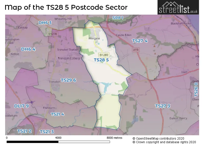
The TS28 5 Postcode shares a border with TS22 5 (Wynyard, BILLINGHAM, Wolviston), TS21 4 (Fishburn), TS27 3 (HARTLEPOOL, Elwick, Hart), TS27 4 (Blackhall Colliery, Castle Eden, Hesleden), TS29 6 (Trimdon, TRIMDON STATION, Trimdon Grange), DH6 2 (Shotton Colliery, South Hetton, Haswell) and DH6 3 (Wheatley Hill, Thornley).
The sector is within the post town of WINGATE.
TS28 5 is a postcode sector within the TS28 postcode district which is within the TS Teeside postcode area.
The Royal Mail delivery office for the TS28 5 postal sector is the Wingate Scale Payment Delivery Office.
The area of the TS28 5 postcode sector is 7.27 square miles which is 18.82 square kilometres or 4,650.28 square acres.

Map of the TS28 5 Postcode Sector
Explore the TS28 5 postcode sector by using our free interactive map.
| T | S | 2 | 8 | - | 5 | X | X |
| T | S | 2 | 8 | Space | 5 | Letter | Letter |
Official List of Streets
WINGATE (75 Streets)
Station Town (20 Streets)
Unofficial Streets or Alternative Spellings
Weather Forecast for TS28 5
Press Button to Show Forecast for Shotton
| Time Period | Icon | Description | Temperature | Rain Probability | Wind |
|---|---|---|---|---|---|
| 21:00 to 00:00 | Cloudy | 6.0°C (feels like 3.0°C) | 5.00% | NE 9 mph |
Press Button to Show Forecast for Shotton
| Time Period | Icon | Description | Temperature | Rain Probability | Wind |
|---|---|---|---|---|---|
| 00:00 to 03:00 | Cloudy | 6.0°C (feels like 3.0°C) | 7.00% | NE 9 mph | |
| 03:00 to 06:00 | Cloudy | 6.0°C (feels like 2.0°C) | 14.00% | NNE 11 mph | |
| 06:00 to 09:00 | Heavy rain | 6.0°C (feels like 2.0°C) | 89.00% | NNE 13 mph | |
| 09:00 to 12:00 | Heavy rain | 6.0°C (feels like 2.0°C) | 92.00% | N 13 mph | |
| 12:00 to 15:00 | Heavy rain | 6.0°C (feels like 2.0°C) | 91.00% | NW 13 mph | |
| 15:00 to 18:00 | Light rain | 7.0°C (feels like 4.0°C) | 58.00% | WNW 11 mph | |
| 18:00 to 21:00 | Light rain shower (day) | 8.0°C (feels like 5.0°C) | 46.00% | W 11 mph | |
| 21:00 to 00:00 | Partly cloudy (night) | 6.0°C (feels like 3.0°C) | 9.00% | WSW 9 mph |
Press Button to Show Forecast for Shotton
| Time Period | Icon | Description | Temperature | Rain Probability | Wind |
|---|---|---|---|---|---|
| 00:00 to 03:00 | Clear night | 5.0°C (feels like 1.0°C) | 0.00% | SW 11 mph | |
| 03:00 to 06:00 | Partly cloudy (night) | 5.0°C (feels like 1.0°C) | 9.00% | SSW 11 mph | |
| 06:00 to 09:00 | Partly cloudy (day) | 6.0°C (feels like 2.0°C) | 6.00% | S 11 mph | |
| 09:00 to 12:00 | Cloudy | 10.0°C (feels like 7.0°C) | 7.00% | SSW 16 mph | |
| 12:00 to 15:00 | Cloudy | 12.0°C (feels like 9.0°C) | 10.00% | S 16 mph | |
| 15:00 to 18:00 | Light rain shower (day) | 13.0°C (feels like 10.0°C) | 34.00% | S 18 mph | |
| 18:00 to 21:00 | Light rain shower (day) | 12.0°C (feels like 9.0°C) | 33.00% | S 16 mph | |
| 21:00 to 00:00 | Cloudy | 11.0°C (feels like 8.0°C) | 6.00% | S 13 mph |
Press Button to Show Forecast for Shotton
| Time Period | Icon | Description | Temperature | Rain Probability | Wind |
|---|---|---|---|---|---|
| 00:00 to 03:00 | Partly cloudy (night) | 9.0°C (feels like 7.0°C) | 2.00% | S 13 mph | |
| 03:00 to 06:00 | Partly cloudy (night) | 8.0°C (feels like 5.0°C) | 2.00% | SSE 11 mph | |
| 06:00 to 09:00 | Sunny day | 8.0°C (feels like 5.0°C) | 2.00% | SSE 11 mph | |
| 09:00 to 12:00 | Sunny day | 12.0°C (feels like 10.0°C) | 1.00% | SE 11 mph | |
| 12:00 to 15:00 | Cloudy | 15.0°C (feels like 12.0°C) | 8.00% | SE 16 mph | |
| 15:00 to 18:00 | Partly cloudy (day) | 15.0°C (feels like 13.0°C) | 8.00% | SE 13 mph | |
| 18:00 to 21:00 | Cloudy | 14.0°C (feels like 12.0°C) | 14.00% | ESE 9 mph | |
| 21:00 to 00:00 | Cloudy | 11.0°C (feels like 9.0°C) | 8.00% | ESE 7 mph |
Press Button to Show Forecast for Shotton
| Time Period | Icon | Description | Temperature | Rain Probability | Wind |
|---|---|---|---|---|---|
| 00:00 to 03:00 | Cloudy | 9.0°C (feels like 8.0°C) | 12.00% | ESE 4 mph | |
| 03:00 to 06:00 | Cloudy | 10.0°C (feels like 9.0°C) | 20.00% | E 4 mph | |
| 06:00 to 09:00 | Overcast | 10.0°C (feels like 9.0°C) | 21.00% | NNE 4 mph | |
| 09:00 to 12:00 | Overcast | 12.0°C (feels like 11.0°C) | 22.00% | NE 7 mph | |
| 12:00 to 15:00 | Overcast | 13.0°C (feels like 12.0°C) | 18.00% | NE 9 mph | |
| 15:00 to 18:00 | Cloudy | 14.0°C (feels like 12.0°C) | 11.00% | NE 11 mph | |
| 18:00 to 21:00 | Overcast | 11.0°C (feels like 10.0°C) | 14.00% | NNE 9 mph | |
| 21:00 to 00:00 | Overcast | 10.0°C (feels like 8.0°C) | 14.00% | NNE 9 mph |
Schools and Places of Education Within the TS28 5 Postcode Sector
Wingate Community Nursery School
Local authority nursery school
Partridge Terrace, Wingate, County Durham, TS28 5BD
Head: Miss Becky Wood
Ofsted Rating: Outstanding
Inspection: 2022-01-13 (835 days ago)
Website: Visit Wingate Community Nursery School Website
Phone: 01429838206
Number of Pupils: 89
Wingate Primary School
Community school
Church Street, Wingate, County Durham, TS28 5AQ
Head: Mrs Marie-Louise Binks
Ofsted Rating: Good
Inspection: 2023-01-18 (465 days ago)
Website: Visit Wingate Primary School Website
Phone: 01429836843
Number of Pupils: 347
House Prices in the TS28 5 Postcode Sector
| Type of Property | 2018 Average | 2018 Sales | 2017 Average | 2017 Sales | 2016 Average | 2016 Sales | 2015 Average | 2015 Sales |
|---|---|---|---|---|---|---|---|---|
| Detached | £200,115 | 25 | £182,316 | 22 | £178,385 | 26 | £166,255 | 19 |
| Semi-Detached | £75,316 | 25 | £86,748 | 21 | £76,577 | 28 | £88,418 | 28 |
| Terraced | £50,202 | 38 | £48,155 | 33 | £53,792 | 35 | £52,397 | 36 |
| Flats | £0 | 0 | £0 | 0 | £60,500 | 2 | £19,250 | 2 |
Important Postcodes TS28 5 in the Postcode Sector
TS28 5AN is the postcode for St. Marys R C V A Primary School
TS28 5AQ is the postcode for Wingate Infant School, Church Street
TS28 5AX is the postcode for Wellfield Community School, North Road East
TS28 5BA is the postcode for Wingate Junior School, Moor Lane
TS28 5BD is the postcode for Wingate Community Nursery School, Partridge Terrace
| The TS28 5 Sector is within these Local Authorities |
|
|---|---|
| The TS28 5 Sector is within these Counties |
|
| The TS28 5 Sector is within these Water Company Areas |
|