The TW14 9 postcode sector is within the county of Greater London.
Did you know? According to the 2021 Census, the TW14 9 postcode sector is home to a bustling 13,925 residents!
Given that each sector allows for 400 unique postcode combinations. Letters C, I, K, M, O and V are not allowed in the last two letters of a postcode. With 177 postcodes already in use, this leaves 223 units available.
The TW14 9 postal code covers the settlement of FELTHAM .
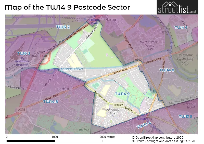
The TW14 9 Postcode shares a border with TW14 0 (FELTHAM ), TW6 2 (LONDON HEATHROW AIRPORT , HEATHROW ), TW13 4 (FELTHAM ), TW14 8 (FELTHAM , BEDFONT , ASHFORD ) and TW13 5 (FELTHAM , HANWORTH ).
The sector is within the post town of FELTHAM.
TW14 9 is a postcode sector within the TW14 postcode district which is within the TW Twickenham postcode area.
The Royal Mail delivery office for the TW14 9 postal sector is the Feltham Delivery Office.
The area of the TW14 9 postcode sector is 1.00 square miles which is 2.60 square kilometres or 641.88 square acres.
Waterways within the TW14 9 postcode sector include the Longford River, Duke of Northumberland's River.

Map of the TW14 9 Postcode Sector
Explore the TW14 9 postcode sector by using our free interactive map.
| T | W | 1 | 4 | - | 9 | X | X |
| T | W | 1 | 4 | Space | 9 | Letter | Letter |
Official List of Streets
FELTHAM (92 Streets)
Unofficial Streets or Alternative Spellings
FELTHAM
CLYMPING DENE COLONIAL ROAD FAGGS ROAD HARLINGTON ROAD EAST HARLINGTON ROAD WEST IMPERIAL ROAD ORCHARD ROAD PEACH ROAD SOUTHVILLE ROAD ALLCOT CLOSE CAMBRIA COURT EASTLEIGH CLOSE EASTLEIGHH CLOSE EMERDALE CLOSE FAGGS ROAD GREAT SOUTH-WEST ROAD LINK ROAD MINIMAX CLOSE SHREWSBURY ROAD SWANSEA ROAD WESMACOTT DRIVE WHITE BRIDGE CLOSEFELTHAM,
STAINES ROADLondon Heathrow Airport
SOUTHERN PERIMETER ROADBedfont
GREAT SOUTH WEST ROAD HATTON ROADWeather Forecast for TW14 9
Press Button to Show Forecast for Heathrow
| Time Period | Icon | Description | Temperature | Rain Probability | Wind |
|---|---|---|---|---|---|
| 09:00 to 12:00 | Overcast | 8.0°C (feels like 6.0°C) | 43.00% | NE 11 mph | |
| 12:00 to 15:00 | Overcast | 11.0°C (feels like 9.0°C) | 11.00% | NE 11 mph | |
| 15:00 to 18:00 | Cloudy | 13.0°C (feels like 11.0°C) | 15.00% | NE 9 mph | |
| 18:00 to 21:00 | Cloudy | 12.0°C (feels like 9.0°C) | 54.00% | NE 11 mph | |
| 21:00 to 00:00 | Light rain | 10.0°C (feels like 7.0°C) | 63.00% | NE 11 mph |
Press Button to Show Forecast for Heathrow
| Time Period | Icon | Description | Temperature | Rain Probability | Wind |
|---|---|---|---|---|---|
| 00:00 to 03:00 | Heavy rain | 9.0°C (feels like 6.0°C) | 86.00% | NNE 11 mph | |
| 03:00 to 06:00 | Heavy rain | 8.0°C (feels like 6.0°C) | 89.00% | NNE 9 mph | |
| 06:00 to 09:00 | Heavy rain | 8.0°C (feels like 6.0°C) | 81.00% | WNW 9 mph | |
| 09:00 to 12:00 | Heavy rain | 9.0°C (feels like 7.0°C) | 81.00% | WNW 9 mph | |
| 12:00 to 15:00 | Light rain | 10.0°C (feels like 7.0°C) | 56.00% | W 13 mph | |
| 15:00 to 18:00 | Cloudy | 11.0°C (feels like 9.0°C) | 17.00% | W 11 mph | |
| 18:00 to 21:00 | Cloudy | 11.0°C (feels like 10.0°C) | 8.00% | WSW 9 mph | |
| 21:00 to 00:00 | Cloudy | 9.0°C (feels like 8.0°C) | 6.00% | SW 7 mph |
Press Button to Show Forecast for Heathrow
| Time Period | Icon | Description | Temperature | Rain Probability | Wind |
|---|---|---|---|---|---|
| 00:00 to 03:00 | Clear night | 8.0°C (feels like 7.0°C) | 3.00% | SW 4 mph | |
| 03:00 to 06:00 | Clear night | 6.0°C (feels like 5.0°C) | 2.00% | SSW 4 mph | |
| 06:00 to 09:00 | Sunny day | 7.0°C (feels like 6.0°C) | 1.00% | S 4 mph | |
| 09:00 to 12:00 | Partly cloudy (day) | 12.0°C (feels like 11.0°C) | 2.00% | S 9 mph | |
| 12:00 to 15:00 | Cloudy | 15.0°C (feels like 12.0°C) | 5.00% | S 11 mph | |
| 15:00 to 18:00 | Partly cloudy (day) | 15.0°C (feels like 13.0°C) | 2.00% | S 13 mph | |
| 18:00 to 21:00 | Sunny day | 14.0°C (feels like 12.0°C) | 1.00% | S 11 mph | |
| 21:00 to 00:00 | Clear night | 11.0°C (feels like 10.0°C) | 2.00% | SSE 7 mph |
Press Button to Show Forecast for Heathrow
| Time Period | Icon | Description | Temperature | Rain Probability | Wind |
|---|---|---|---|---|---|
| 00:00 to 03:00 | Clear night | 10.0°C (feels like 8.0°C) | 1.00% | SE 7 mph | |
| 03:00 to 06:00 | Clear night | 9.0°C (feels like 8.0°C) | 3.00% | ESE 7 mph | |
| 06:00 to 09:00 | Sunny day | 10.0°C (feels like 8.0°C) | 4.00% | ESE 7 mph | |
| 09:00 to 12:00 | Partly cloudy (day) | 14.0°C (feels like 12.0°C) | 5.00% | ESE 9 mph | |
| 12:00 to 15:00 | Cloudy | 16.0°C (feels like 14.0°C) | 13.00% | SE 11 mph | |
| 15:00 to 18:00 | Cloudy | 17.0°C (feels like 15.0°C) | 12.00% | SE 11 mph | |
| 18:00 to 21:00 | Cloudy | 16.0°C (feels like 14.0°C) | 10.00% | SE 9 mph | |
| 21:00 to 00:00 | Partly cloudy (night) | 13.0°C (feels like 12.0°C) | 6.00% | ESE 7 mph |
Schools and Places of Education Within the TW14 9 Postcode Sector
Bedfont Primary School
Community school
Hatton Road, London, , TW14 9QZ
Head: Mrs Gemma Donnelly
Ofsted Rating: Good
Inspection: 2023-12-06 (143 days ago)
Website: Visit Bedfont Primary School Website
Phone: 02088904755
Number of Pupils: 607
Marjory Kinnon School
Community special school
Hatton Road, Feltham, , TW14 9QZ
Head: Ms Tracy Meredith
Ofsted Rating: Good
Inspection: 2022-12-08 (506 days ago)
Website: Visit Marjory Kinnon School Website
Phone: 02088902032
Number of Pupils: 318
Rivers Academy West London
Academy converter
Tachbrook Road, Feltham, Middlesex, TW14 9PE
Head: Mr Luke Homer
Ofsted Rating: Good
Inspection: 2019-01-30 (1914 days ago)
Website: Visit Rivers Academy West London Website
Phone: 02088900245
Number of Pupils: 977
Southville Primary School
Community school
Bedfont Lane, Feltham, , TW14 9NP
Head: Ms Joanne Lacey
Ofsted Rating: Good
Inspection: 2023-01-18 (465 days ago)
Website: Visit Southville Primary School Website
Phone: 02088906745
Number of Pupils: 670
Space Studio West London
Studio schools
Letchworth Avenue, Hounslow, , TW14 9PE
Head: Andrew Morgan
Ofsted Rating: Good
Inspection: 2023-02-09 (443 days ago)
Website: Visit Space Studio West London Website
Phone: 02036968140
Number of Pupils: 199
House Prices in the TW14 9 Postcode Sector
| Type of Property | 2018 Average | 2018 Sales | 2017 Average | 2017 Sales | 2016 Average | 2016 Sales | 2015 Average | 2015 Sales |
|---|---|---|---|---|---|---|---|---|
| Detached | £560,500 | 5 | £445,000 | 5 | £409,417 | 6 | £364,251 | 8 |
| Semi-Detached | £392,112 | 62 | £395,438 | 43 | £369,699 | 42 | £321,329 | 51 |
| Terraced | £362,850 | 37 | £340,876 | 21 | £339,242 | 33 | £290,972 | 36 |
| Flats | £255,238 | 30 | £238,844 | 26 | £244,392 | 34 | £217,979 | 36 |
Important Postcodes TW14 9 in the Postcode Sector
TW14 9NN is the postcode for Council Depot, Ashmead Road
TW14 9NP is the postcode for Southville Infant & Nursery School, Bedfont Lane, and Southville Primary School, Bedfont Lane
TW14 9PE is the postcode for Sixth form block, Rivers Academy West London, Tachbrook Road, 6TH FORM BLOCK, Rivers Academy West London, Tachbrook Road, Gym block, Rivers Academy West London, Tachbrook Road, NEW BLOCK H, Rivers Academy West London, Tachbrook Road, MAIN BUILDING, Rivers Academy West London, Tachbrook Road, HUMANITIES BLOCK, Rivers Academy West London, Tachbrook Road, GYM, Rivers Academy West London, Tachbrook Road, MAIN BUILDING, Longford Community School, Tachbrook Road, and 6TH FORM BLOCK, Longford Community School, Tachbrook Road
TW14 9PZ is the postcode for TWO BRIDGES DAY CENTRE, 2a, Marriott Close
TW14 9QZ is the postcode for Bedfont Primary School, Hatton Road, Bedfont Infant & Nursery School, Hatton Road, and The Marjory Kinnon School, Hatton Road
TW14 9RR is the postcode for Sandbanks Resource Centre, Beattie Close
| The TW14 9 Sector is within these Local Authorities |
|
|---|---|
| The TW14 9 Sector is within these Counties |
|
| The TW14 9 Sector is within these Water Company Areas |
|