The TW15 3 postcode sector stands on the Greater London and Surrey border.
Did you know? According to the 2021 Census, the TW15 3 postcode sector is home to a bustling 9,520 residents!
Given that each sector allows for 400 unique postcode combinations. Letters C, I, K, M, O and V are not allowed in the last two letters of a postcode. With 194 postcodes already in use, this leaves 206 units available.
The TW15 3 postal code covers the settlement of ASHFORD .
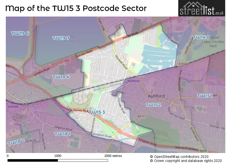
The TW15 3 Postcode shares a border with TW14 8 (FELTHAM , BEDFONT , ASHFORD ), TW15 2 (ASHFORD ), TW18 1 (STAINES-UPON-THAMES , LALEHAM ), TW18 4 (STAINES-UPON-THAMES , STAINES , WRAYSBURY ) and TW19 7 (STANWELL).
The sector is within the post town of ASHFORD.
TW15 3 is a postcode sector within the TW15 postcode district which is within the TW Twickenham postcode area.
The Royal Mail delivery office for the TW15 3 postal sector is the Ashford (tw) Delivery Office.
The area of the TW15 3 postcode sector is 1.10 square miles which is 2.85 square kilometres or 704.05 square acres.
The TW15 3 postcode sector is crossed by the A30 Major A road.
Waterways within the TW15 3 postcode sector include the Staines Aqueduct, River Ash.

Map of the TW15 3 Postcode Sector
Explore the TW15 3 postcode sector by using our free interactive map.
| T | W | 1 | 5 | - | 3 | X | X |
| T | W | 1 | 5 | Space | 3 | Letter | Letter |
Official List of Streets
ASHFORD (62 Streets)
Unofficial Streets or Alternative Spellings
STAINES-UPON-THAMES
ASHFORD ROAD SHORT LANEASHFORD
FAIRHOLME ROAD RUGGLES-BRISE ROAD STANLEY ROAD TENNYSON ROAD THE WICKETS WOLSEY ROADStanwell
LONG LANE TOWN LANEFELTHAM,
STAINES ROAD BUXTON ROAD ELLIES MEWS FERN WALK SAINT HILDAS AVENUE ST MARTINS COURT STAINES BY-PASSASHFORD,
KINGSTON ROAD LONDON ROAD STAINES ROAD WESTWeather Forecast for TW15 3
Press Button to Show Forecast for Staines
| Time Period | Icon | Description | Temperature | Rain Probability | Wind |
|---|---|---|---|---|---|
| 18:00 to 21:00 | Partly cloudy (day) | 19.0°C (feels like 19.0°C) | 1.00% | SE 4 mph | |
| 21:00 to 00:00 | Cloudy | 14.0°C (feels like 13.0°C) | 3.00% | S 7 mph |
Press Button to Show Forecast for Staines
| Time Period | Icon | Description | Temperature | Rain Probability | Wind |
|---|---|---|---|---|---|
| 00:00 to 03:00 | Cloudy | 13.0°C (feels like 12.0°C) | 4.00% | SSW 7 mph | |
| 03:00 to 06:00 | Cloudy | 12.0°C (feels like 12.0°C) | 3.00% | SSW 4 mph | |
| 06:00 to 09:00 | Partly cloudy (day) | 12.0°C (feels like 12.0°C) | 1.00% | SW 4 mph | |
| 09:00 to 12:00 | Sunny day | 16.0°C (feels like 16.0°C) | 0.00% | SSW 2 mph | |
| 12:00 to 15:00 | Partly cloudy (day) | 19.0°C (feels like 19.0°C) | 0.00% | S 2 mph | |
| 15:00 to 18:00 | Cloudy | 21.0°C (feels like 21.0°C) | 3.00% | NE 2 mph | |
| 18:00 to 21:00 | Cloudy | 20.0°C (feels like 20.0°C) | 3.00% | S 4 mph | |
| 21:00 to 00:00 | Partly cloudy (night) | 17.0°C (feels like 16.0°C) | 1.00% | SSW 4 mph |
Press Button to Show Forecast for Staines
| Time Period | Icon | Description | Temperature | Rain Probability | Wind |
|---|---|---|---|---|---|
| 00:00 to 03:00 | Cloudy | 15.0°C (feels like 15.0°C) | 3.00% | SW 2 mph | |
| 03:00 to 06:00 | Cloudy | 13.0°C (feels like 13.0°C) | 3.00% | S 2 mph | |
| 06:00 to 09:00 | Cloudy | 13.0°C (feels like 13.0°C) | 4.00% | SSE 2 mph | |
| 09:00 to 12:00 | Cloudy | 17.0°C (feels like 17.0°C) | 4.00% | E 2 mph | |
| 12:00 to 15:00 | Cloudy | 20.0°C (feels like 20.0°C) | 4.00% | ESE 4 mph | |
| 15:00 to 18:00 | Cloudy | 22.0°C (feels like 21.0°C) | 3.00% | ESE 4 mph | |
| 18:00 to 21:00 | Cloudy | 21.0°C (feels like 20.0°C) | 3.00% | SE 7 mph | |
| 21:00 to 00:00 | Partly cloudy (night) | 18.0°C (feels like 16.0°C) | 0.00% | ESE 7 mph |
Press Button to Show Forecast for Staines
| Time Period | Icon | Description | Temperature | Rain Probability | Wind |
|---|---|---|---|---|---|
| 00:00 to 03:00 | Clear night | 15.0°C (feels like 14.0°C) | 1.00% | ESE 4 mph | |
| 03:00 to 06:00 | Clear night | 13.0°C (feels like 13.0°C) | 0.00% | E 4 mph | |
| 06:00 to 09:00 | Sunny day | 14.0°C (feels like 14.0°C) | 0.00% | ENE 4 mph | |
| 09:00 to 12:00 | Sunny day | 18.0°C (feels like 18.0°C) | 0.00% | E 4 mph | |
| 12:00 to 15:00 | Partly cloudy (day) | 22.0°C (feels like 21.0°C) | 0.00% | SE 7 mph | |
| 15:00 to 18:00 | Partly cloudy (day) | 23.0°C (feels like 21.0°C) | 1.00% | SE 7 mph | |
| 18:00 to 21:00 | Sunny day | 22.0°C (feels like 20.0°C) | 1.00% | SE 9 mph | |
| 21:00 to 00:00 | Clear night | 18.0°C (feels like 17.0°C) | 1.00% | ESE 7 mph |
Press Button to Show Forecast for Staines
| Time Period | Icon | Description | Temperature | Rain Probability | Wind |
|---|---|---|---|---|---|
| 00:00 to 03:00 | Clear night | 16.0°C (feels like 15.0°C) | 0.00% | ESE 7 mph | |
| 03:00 to 06:00 | Partly cloudy (night) | 15.0°C (feels like 14.0°C) | 0.00% | E 4 mph | |
| 06:00 to 09:00 | Partly cloudy (day) | 15.0°C (feels like 15.0°C) | 1.00% | E 4 mph | |
| 09:00 to 12:00 | Partly cloudy (day) | 19.0°C (feels like 18.0°C) | 2.00% | ESE 7 mph | |
| 12:00 to 15:00 | Cloudy | 22.0°C (feels like 21.0°C) | 7.00% | SE 9 mph | |
| 15:00 to 18:00 | Cloudy | 23.0°C (feels like 21.0°C) | 8.00% | SSE 9 mph | |
| 18:00 to 21:00 | Cloudy | 22.0°C (feels like 20.0°C) | 12.00% | S 9 mph | |
| 21:00 to 00:00 | Cloudy | 19.0°C (feels like 17.0°C) | 9.00% | S 7 mph |
Schools and Places of Education Within the TW15 3 Postcode Sector
Ashford Park Primary School
Community school
Station Crescent, Ashford, Surrey, TW15 3HN
Head: Mr Peter Boulton
Ofsted Rating: Good
Inspection: 2018-09-26 (2051 days ago)
Website: Visit Ashford Park Primary School Website
Phone: 01784250305
Number of Pupils: 629
Thomas Knyvett College
Academy converter
Stanwell Road, Ashford, Surrey, TW15 3DU
Head: Ms Jeanette Cochrane
Ofsted Rating: Requires improvement
Inspection: 2023-11-15 (175 days ago)
Website: Visit Thomas Knyvett College Website
Phone: 01784243824
Number of Pupils: 729
House Prices in the TW15 3 Postcode Sector
| Type of Property | 2018 Average | 2018 Sales | 2017 Average | 2017 Sales | 2016 Average | 2016 Sales | 2015 Average | 2015 Sales |
|---|---|---|---|---|---|---|---|---|
| Detached | £544,800 | 20 | £504,683 | 30 | £456,289 | 19 | £423,218 | 36 |
| Semi-Detached | £426,792 | 52 | £424,950 | 46 | £398,653 | 68 | £362,653 | 64 |
| Terraced | £356,122 | 25 | £361,932 | 30 | £352,375 | 20 | £319,916 | 25 |
| Flats | £261,220 | 30 | £273,262 | 38 | £263,805 | 29 | £232,618 | 44 |
Important Postcodes TW15 3 in the Postcode Sector
TW15 3AA is the postcode for Ashford and St Peter's Hospitals NHS Trust, Ashford Hospital, London Road, CEDAR UNIT, Ashford and St Peter's Hospitals NHS Trust, Ashford Hospital, and Ashford and St Peter's Hospitals NHS Trust, Ashford Hospital
TW15 3DU is the postcode for Ashford Clinic, Stanwell Road, Surrey County Council, Ashford Centre, Stanwell Road, BROOKLANDS TECHNICAL COLLEGE, STANWELL ROAD, ASHFORD, GYM BLOCK, Thomas Knyvett College, Stanwell Road, Brooklands Technical College, Stanwell Road, and Thomas Knyvett College, Stanwell Road
TW15 3HN is the postcode for Ashford Park Primary School, Station Crescent
TW15 3JZ is the postcode for H M P Bronzefield, Woodthorpe Road, and ENTRANCE BLOCK, H M P Bronzefield, Woodthorpe Road
TW15 3SE is the postcode for Whitehouse Depot, Kingston Road
TW15 3SL is the postcode for FORDBRIDGE FIRE STATION, KINGSTON ROAD, and Surrey Fire & Rescue Service, Fire Station, Kingston Road
| The TW15 3 Sector is within these Local Authorities |
|
|---|---|
| The TW15 3 Sector is within these Counties |
|
| The TW15 3 Sector is within these Water Company Areas |
|