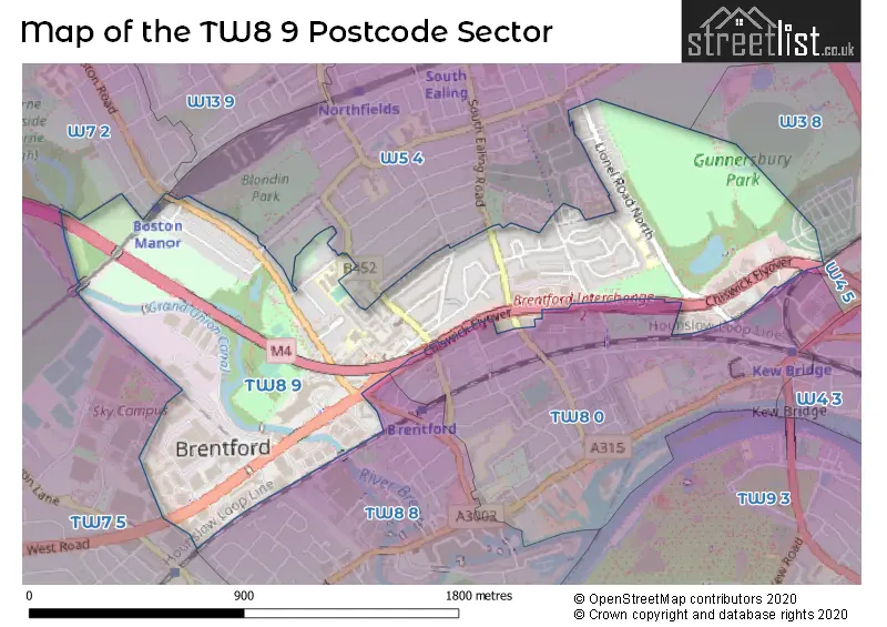
The TW8 9 postcode sector is within the county of Greater London.
Did you know? According to the 2021 Census, the TW8 9 postcode sector is home to a bustling 6,327 residents!
Given that each sector allows for 400 unique postcode combinations. Letters C, I, K, M, O and V are not allowed in the last two letters of a postcode. With 144 postcodes already in use, this leaves 256 units available.
The TW8 9 postal code covers the settlement of BRENTFORD .
The TW8 9 Postcode shares a border with TW7 5 (ISLEWORTH , BRENTFORD ), TW8 0 (BRENTFORD ), TW8 8 (BRENTFORD , ISLEWORTH ), W3 8 (ACTON , LONDON ), W4 5 (CHISWICK ), W7 2 (HANWELL ) and W5 4 (EALING , CHISWICK , LONDON ).
The sector is within the post town of BRENTFORD.
TW8 9 is a postcode sector within the TW8 postcode district which is within the TW Twickenham postcode area.
The Royal Mail delivery office for the TW8 9 postal sector is the Brentford & Isleworth Delivery Office.
The area of the TW8 9 postcode sector is 0.83 square miles which is 2.16 square kilometres or 532.95 square acres.
The TW8 9 postcode sector is crossed by the M4 motorway.
Waterways within the TW8 9 postcode sector include the River Brent, Grand Union Canal (Brentford Branch).

Map of the TW8 9 Postcode Sector
Explore the TW8 9 postcode sector by using our free interactive map.
| T | W | 8 | - | 9 | X | X |
| T | W | 8 | Space | 9 | Letter | Letter |
Official List of Streets
BRENTFORD (45 Streets)
Unofficial Streets or Alternative Spellings
BRENTFORD
BROOK LANE NORTH CLITHEROW PASSAGE GALLOWS BRIDGE GRAND UNION CANAL TOWPATH YORK PARADEEaling
BOSTON ROAD JUNCTION ROAD SOUTH EALING ROAD STERLING PLACE SWYNCOMBE AVENUE WINDMILL ROADHounslow
CLAYPONDS GARDENSHammersmith and Fulham
GREAT WEST ROADWeather Forecast for TW8 9
Press Button to Show Forecast for Syon House
| Time Period | Icon | Description | Temperature | Rain Probability | Wind |
|---|---|---|---|---|---|
| 18:00 to 21:00 | Sunny day | 14.0°C (feels like 11.0°C) | 0.00% | SSW 11 mph | |
| 21:00 to 00:00 | Clear night | 11.0°C (feels like 9.0°C) | 0.00% | SSE 7 mph |
Press Button to Show Forecast for Syon House
| Time Period | Icon | Description | Temperature | Rain Probability | Wind |
|---|---|---|---|---|---|
| 00:00 to 03:00 | Clear night | 9.0°C (feels like 8.0°C) | 0.00% | SSE 7 mph | |
| 03:00 to 06:00 | Clear night | 8.0°C (feels like 7.0°C) | 0.00% | SE 4 mph | |
| 06:00 to 09:00 | Sunny day | 9.0°C (feels like 8.0°C) | 0.00% | ESE 4 mph | |
| 09:00 to 12:00 | Sunny day | 15.0°C (feels like 13.0°C) | 1.00% | SSE 9 mph | |
| 12:00 to 15:00 | Partly cloudy (day) | 17.0°C (feels like 14.0°C) | 3.00% | SSE 11 mph | |
| 15:00 to 18:00 | Cloudy | 17.0°C (feels like 14.0°C) | 10.00% | S 11 mph | |
| 18:00 to 21:00 | Partly cloudy (day) | 15.0°C (feels like 14.0°C) | 7.00% | SSE 7 mph | |
| 21:00 to 00:00 | Partly cloudy (night) | 12.0°C (feels like 11.0°C) | 7.00% | SE 4 mph |
Press Button to Show Forecast for Syon House
| Time Period | Icon | Description | Temperature | Rain Probability | Wind |
|---|---|---|---|---|---|
| 00:00 to 03:00 | Cloudy | 11.0°C (feels like 10.0°C) | 9.00% | SSE 4 mph | |
| 03:00 to 06:00 | Cloudy | 10.0°C (feels like 9.0°C) | 8.00% | S 4 mph | |
| 06:00 to 09:00 | Partly cloudy (day) | 10.0°C (feels like 10.0°C) | 6.00% | N 4 mph | |
| 09:00 to 12:00 | Cloudy | 13.0°C (feels like 13.0°C) | 10.00% | NNW 2 mph | |
| 12:00 to 15:00 | Overcast | 15.0°C (feels like 15.0°C) | 14.00% | NE 2 mph | |
| 15:00 to 18:00 | Cloudy | 16.0°C (feels like 15.0°C) | 13.00% | NNE 4 mph | |
| 18:00 to 21:00 | Cloudy | 15.0°C (feels like 14.0°C) | 15.00% | NE 7 mph | |
| 21:00 to 00:00 | Cloudy | 13.0°C (feels like 13.0°C) | 19.00% | NNE 4 mph |
Press Button to Show Forecast for Syon House
| Time Period | Icon | Description | Temperature | Rain Probability | Wind |
|---|---|---|---|---|---|
| 00:00 to 03:00 | Light rain shower (night) | 12.0°C (feels like 11.0°C) | 39.00% | NNW 4 mph | |
| 03:00 to 06:00 | Light rain | 11.0°C (feels like 10.0°C) | 42.00% | NNW 7 mph | |
| 06:00 to 09:00 | Overcast | 11.0°C (feels like 10.0°C) | 17.00% | NW 7 mph | |
| 09:00 to 12:00 | Overcast | 14.0°C (feels like 12.0°C) | 16.00% | NW 7 mph | |
| 12:00 to 15:00 | Cloudy | 16.0°C (feels like 15.0°C) | 9.00% | NW 9 mph | |
| 15:00 to 18:00 | Partly cloudy (day) | 18.0°C (feels like 17.0°C) | 8.00% | NW 9 mph | |
| 18:00 to 21:00 | Cloudy | 17.0°C (feels like 16.0°C) | 10.00% | NNW 9 mph | |
| 21:00 to 00:00 | Partly cloudy (night) | 14.0°C (feels like 13.0°C) | 5.00% | NNW 9 mph |
Schools and Places of Education Within the TW8 9 Postcode Sector
Gunnersbury Catholic School
Voluntary aided school
The Ride, Brentford, , TW8 9LB
Head: Mr K Burke
Ofsted Rating: Outstanding
Inspection: 2023-01-18 (467 days ago)
Website: Visit Gunnersbury Catholic School Website
Phone: 02085687281
Number of Pupils: 1192
Lionel Primary School
Community school
Lionel Road North, Brentford, , TW8 9QT
Head: Mrs M Hone
Ofsted Rating: Outstanding
Inspection: 2015-07-02 (3224 days ago)
Website: Visit Lionel Primary School Website
Phone: 02085605323
Number of Pupils: 647
Our Lady and St John's Catholic Primary School
Voluntary aided school
Boston Park Road, Brentford, Middlesex, TW8 9JF
Head: Mrs Sue Cunningham
Ofsted Rating: Good
Inspection: 2018-10-09 (2029 days ago)
Website: Visit Our Lady and St John's Catholic Primary School Website
Phone: 02085607477
Number of Pupils: 221
House Prices in the TW8 9 Postcode Sector
| Type of Property | 2018 Average | 2018 Sales | 2017 Average | 2017 Sales | 2016 Average | 2016 Sales | 2015 Average | 2015 Sales |
|---|---|---|---|---|---|---|---|---|
| Detached | £0 | 0 | £0 | 0 | £1,575,000 | 1 | £1,277,500 | 2 |
| Semi-Detached | £589,833 | 9 | £721,859 | 11 | £692,742 | 8 | £507,071 | 7 |
| Terraced | £644,278 | 27 | £635,010 | 26 | £592,771 | 24 | £584,420 | 25 |
| Flats | £295,373 | 22 | £326,126 | 29 | £320,050 | 40 | £290,931 | 41 |
Important Postcodes TW8 9 in the Postcode Sector
TW8 9DU is the postcode for Syon Clinic, 941 Great West Road
TW8 9GA is the postcode for BLOCK H PARAGON SITE, University of West London, Block G Paragon Site, University of West London, Block G Paragon Site, and University of West London, Block G Paragon Site, Boston Manor Road
TW8 9JF is the postcode for Our Lady & St. John RC Primary School, Boston Park Road, and Our Lady and St John's Catholic Primary School, Boston Park Road
TW8 9JX is the postcode for Boston Manor House, Boston Manor Road
TW8 9LB is the postcode for 7-9 The Ride, 6TH FORM BLOCK, Gunnersbury Catholic School for Boys, The Ride, MUSIC BLOCK, Gunnersbury Catholic School for Boys, The Ride, GUNNERSBURY CATHOLIC HIGH SCHOOL - SCIENCE WORKSHOPS, Gunnersbury Catholic School for Boys, The Ride, DT/SCIENCE, Gunnersbury Catholic School for Boys, The Ride, BUSINESS, Gunnersbury Catholic School for Boys, The Ride, GUNNERSBURY CATHOLIC HIGH SCHOOL - MAIN TEACHING BLOCK, Gunnersbury Catholic School for Boys, The Ride, RECEPTION, Gunnersbury Catholic School for Boys, The Ride, MAIN BLOCK, Gunnersbury Catholic School for Boys, The Ride, GYM, Gunnersbury Catholic School for Boys, The Ride, and BLOCKS B&C, Gunnersbury Catholic School for Boys, The Ride
TW8 9QT is the postcode for NEW FORM ENTRY BUILDING, Lionel Road School, Lionel Road North, Lionel Road School, Lionel Road North, and Lionel Primary School, Lionel Road North
| The TW8 9 Sector is within these Local Authorities |
|
|---|---|
| The TW8 9 Sector is within these Counties |
|
| The TW8 9 Sector is within these Water Company Areas |
|