The UB11 1 postcode sector is within the county of Greater London.
Given that each sector allows for 400 unique postcode combinations. Letters C, I, K, M, O and V are not allowed in the last two letters of a postcode. With 22 postcodes already in use, this leaves 378 units available.
The sector is within the post town of UXBRIDGE.
UB11 1 is a postcode sector within the UB1 postcode district which is within the UB Uxbridge postcode area.
The Royal Mail delivery office for the UB11 1 postal sector is the Southall Delivery Office.
The area of the UB11 1 postcode sector is 0.38 square miles which is 0.99 square kilometres or 245.76 square acres.
Waterways within the UB11 1 postcode sector include the Grand Union Canal.

Map of the UB11 1 Postcode Sector
Explore the UB11 1 postcode sector by using our free interactive map.
| U | B | 1 | 1 | - | 1 | X | X |
| U | B | 1 | 1 | Space | 1 | Letter | Letter |
Official List of Streets
Stockley Park (6 Streets)
UXBRIDGE (1 Streets)
Unofficial Streets or Alternative Spellings
Stockley Park
BENNETSFIELD ROADHAYES
DAWLEY ROADUXBRIDGE,
STOCKLEY ROADYiewsley
HORTON ROAD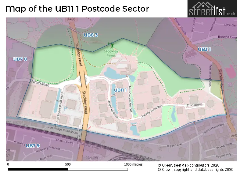
House Prices in the UB11 1 Postcode Sector
| Type of Property | 2018 Average | 2018 Sales | 2017 Average | 2017 Sales | 2016 Average | 2016 Sales | 2015 Average | 2015 Sales |
|---|---|---|---|---|---|---|---|---|
| Detached | £0 | 0 | £0 | 0 | £0 | 0 | £0 | 0 |
| Semi-Detached | £0 | 0 | £0 | 0 | £0 | 0 | £0 | 0 |
| Terraced | £0 | 0 | £0 | 0 | £0 | 0 | £0 | 0 |
| Flats | £0 | 0 | £0 | 0 | £0 | 0 | £0 | 0 |
| The UB11 1 Sector is within these Local Authorities |
|
|---|---|
| The UB11 1 Sector is within these Counties |
|
| The UB11 1 Sector is within these Water Company Areas |
|