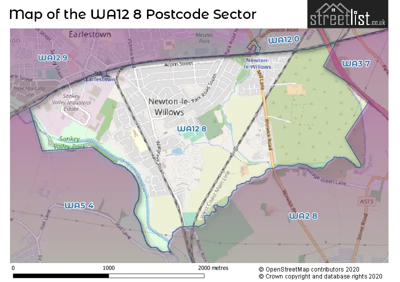
The WA12 8 postcode sector stands on the Cheshire and Merseyside border.
Did you know? According to the 2021 Census, the WA12 8 postcode sector is home to a bustling 9,053 residents!
Given that each sector allows for 400 unique postcode combinations. Letters C, I, K, M, O and V are not allowed in the last two letters of a postcode. With 196 postcodes already in use, this leaves 204 units available.
The WA12 8 postal code covers the settlement of NEWTON-LE-WILLOWS.
The WA12 8 Postcode shares a border with WA3 7 (Birchwood, Croft), WA12 0 (NEWTON-LE-WILLOWS), WA2 8 (WARRINGTON, Winwick, Winwick Quay), WA5 4 (Burtonwood, Collins Green) and WA12 9 (NEWTON-LE-WILLOWS).
The sector is within the post town of NEWTON-LE-WILLOWS.
WA12 8 is a postcode sector within the WA12 postcode district which is within the WA Warrington postcode area.
The Royal Mail delivery office for the WA12 8 postal sector is the Newton Le Willows Delivery Office.
The area of the WA12 8 postcode sector is 1.59 square miles which is 4.12 square kilometres or 1,019.29 square acres.
The WA12 8 postcode sector is crossed by the M6 motorway.
Waterways within the WA12 8 postcode sector include the St Helens Canal, Sankey Brook, Newton Brook.

Map of the WA12 8 Postcode Sector
Explore the WA12 8 postcode sector by using our free interactive map.
| W | A | 1 | 2 | - | 8 | X | X |
| W | A | 1 | 2 | Space | 8 | Letter | Letter |
Official List of Streets
NEWTON-LE-WILLOWS (121 Streets)
Unofficial Streets or Alternative Spellings
NEWTON-LE-WILLOWS
CHEMICAL STREET CHURCH STREET DUKE STREET QUEEN STREET RAILWAY STREET SANKEY STREET SOUTHWORTH ROADWinwick
ALDER ROOT LANE NEWTON ROAD BACK DERBY ROW BACK LIVERPOOL ROW BACK MANCHESTER ROW BUNGALOW ROAD CEDAR STREET CENTRAL WAY CHURCH DRIVE FARM WAY HEY WOOD CLOSE KENT WAY MC CORQUODALE GARDENS NEWTON-LE-WILLOWS INTERCHANGE NEWTON-LE-WILLOWS STATION SUBWAY PARKSIDE LINK ROAD WEST PARVAND CLOSE PENINSULR DRIVE RED BANK SCHOOL COTTAGES THE CLOSEWeather Forecast for WA12 8
Press Button to Show Forecast for Newton-Le-Willows
| Time Period | Icon | Description | Temperature | Rain Probability | Wind |
|---|---|---|---|---|---|
| 00:00 to 03:00 | Partly cloudy (night) | 5.0°C (feels like 3.0°C) | 2.00% | E 7 mph | |
| 03:00 to 06:00 | Clear night | 3.0°C (feels like 1.0°C) | 1.00% | ENE 4 mph | |
| 06:00 to 09:00 | Sunny day | 3.0°C (feels like 1.0°C) | 1.00% | ENE 4 mph | |
| 09:00 to 12:00 | Cloudy | 7.0°C (feels like 6.0°C) | 4.00% | E 4 mph | |
| 12:00 to 15:00 | Cloudy | 9.0°C (feels like 8.0°C) | 6.00% | E 4 mph | |
| 15:00 to 18:00 | Cloudy | 10.0°C (feels like 9.0°C) | 8.00% | E 4 mph | |
| 18:00 to 21:00 | Cloudy | 9.0°C (feels like 8.0°C) | 6.00% | NE 4 mph | |
| 21:00 to 00:00 | Cloudy | 6.0°C (feels like 4.0°C) | 6.00% | NE 7 mph |
Press Button to Show Forecast for Newton-Le-Willows
| Time Period | Icon | Description | Temperature | Rain Probability | Wind |
|---|---|---|---|---|---|
| 00:00 to 03:00 | Partly cloudy (night) | 5.0°C (feels like 2.0°C) | 5.00% | E 7 mph | |
| 03:00 to 06:00 | Partly cloudy (night) | 3.0°C (feels like 1.0°C) | 4.00% | E 4 mph | |
| 06:00 to 09:00 | Partly cloudy (day) | 4.0°C (feels like 1.0°C) | 4.00% | E 7 mph | |
| 09:00 to 12:00 | Partly cloudy (day) | 8.0°C (feels like 6.0°C) | 5.00% | ESE 7 mph | |
| 12:00 to 15:00 | Overcast | 10.0°C (feels like 9.0°C) | 15.00% | E 7 mph | |
| 15:00 to 18:00 | Overcast | 11.0°C (feels like 9.0°C) | 20.00% | E 9 mph | |
| 18:00 to 21:00 | Cloudy | 10.0°C (feels like 8.0°C) | 14.00% | ENE 9 mph | |
| 21:00 to 00:00 | Cloudy | 7.0°C (feels like 5.0°C) | 15.00% | ENE 9 mph |
Press Button to Show Forecast for Newton-Le-Willows
| Time Period | Icon | Description | Temperature | Rain Probability | Wind |
|---|---|---|---|---|---|
| 00:00 to 03:00 | Overcast | 6.0°C (feels like 3.0°C) | 18.00% | NE 7 mph | |
| 03:00 to 06:00 | Cloudy | 5.0°C (feels like 3.0°C) | 18.00% | NNE 9 mph | |
| 06:00 to 09:00 | Light rain | 6.0°C (feels like 3.0°C) | 49.00% | NNE 9 mph | |
| 09:00 to 12:00 | Heavy rain | 8.0°C (feels like 5.0°C) | 70.00% | NNE 9 mph | |
| 12:00 to 15:00 | Heavy rain | 9.0°C (feels like 7.0°C) | 73.00% | N 9 mph | |
| 15:00 to 18:00 | Heavy rain | 10.0°C (feels like 8.0°C) | 76.00% | NNW 9 mph | |
| 18:00 to 21:00 | Light rain shower (day) | 10.0°C (feels like 8.0°C) | 37.00% | NNW 9 mph | |
| 21:00 to 00:00 | Clear night | 7.0°C (feels like 6.0°C) | 11.00% | NW 7 mph |
Schools and Places of Education Within the WA12 8 Postcode Sector
Ascent Autism Specialist College
Special post 16 institution
Remarkable Autism Ltd, 449 Wargrave Road, Newton-le-Willows, Merseyside, WA12 8RS
Head: Mrs Julliet Doherty
Ofsted Rating: Good
Inspection: 2019-09-27 (1673 days ago)
Website: Visit Ascent Autism Specialist College Website
Phone: 01925224899
Number of Pupils: 0
Wargrave CofE Primary School
Voluntary controlled school
Bradlegh Road, Newton-le-Willows, Merseyside, WA12 8QL
Head: Miss Amanda Epstein
Ofsted Rating: Good
Inspection: 2021-06-23 (1038 days ago)
Website: Visit Wargrave CofE Primary School Website
Phone: 01744678720
Number of Pupils: 419
Wargrave House School
Non-maintained special school
449 Wargrave Road, Newton-le-Willows, Merseyside, WA12 8RS
Head: Mr Carl Glennon
Ofsted Rating: Good
Inspection: 2022-05-05 (722 days ago)
Website: Visit Wargrave House School Website
Phone: 01925224899
Number of Pupils: 64
Willow Bank School
Community special school
Winwick Road, Newton-le-Willows, Merseyside, WA12 8DE
Head: Ms Anne Kyle
Ofsted Rating: Good
Inspection: 2022-04-27 (730 days ago)
Website: Visit Willow Bank School Website
Phone: 01744678745
Number of Pupils: 60
House Prices in the WA12 8 Postcode Sector
| Type of Property | 2018 Average | 2018 Sales | 2017 Average | 2017 Sales | 2016 Average | 2016 Sales | 2015 Average | 2015 Sales |
|---|---|---|---|---|---|---|---|---|
| Detached | £210,844 | 36 | £222,590 | 58 | £217,275 | 67 | £198,339 | 59 |
| Semi-Detached | £151,414 | 48 | £136,793 | 55 | £136,100 | 45 | £133,353 | 56 |
| Terraced | £116,096 | 63 | £113,265 | 65 | £122,867 | 59 | £103,412 | 56 |
| Flats | £85,049 | 6 | £91,667 | 3 | £76,375 | 4 | £74,250 | 2 |
Important Postcodes WA12 8 in the Postcode Sector
WA12 8BG is the postcode for SPECIALIST BLOCK MILL GREEN SCHOOL, Mill Green Special School, Mill Lane, and Mill Green Special School, Mill Lane
WA12 8EA is the postcode for Red Bank Community Home, Winwick Road, and SECURE UNIT, Red Bank Community Home, Winwick Road
WA12 8QL is the postcode for Wargrave Ce Primary School, Bradlegh Road, and Wargrave C of E Primary School, Bradlegh Road
WA12 8RA is the postcode for Newton Community Hospital, Sims House, Bradlegh Road
WA12 8RB is the postcode for Newton Community Hospital, Bradlegh Road
| The WA12 8 Sector is within these Local Authorities |
|
|---|---|
| The WA12 8 Sector is within these Counties |
|
| The WA12 8 Sector is within these Water Company Areas |
|