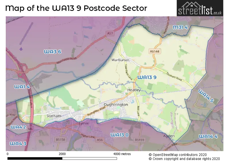
The WA13 9 postcode sector stands on the Cheshire and Greater Manchester border.
Did you know? According to the 2021 Census, the WA13 9 postcode sector is home to a bustling 6,502 residents!
Given that each sector allows for 400 unique postcode combinations. Letters C, I, K, M, O and V are not allowed in the last two letters of a postcode. With 247 postcodes already in use, this leaves 153 units available.
The largest settlements in the WA13 9 postal code are LYMM and Warburton.
The WA13 9 Postcode shares a border with WA3 6 (Birchwood, Rixton, Risley), WA14 4 (ALTRINCHAM, Broadheath, Little Bollington), WA13 0 (LYMM), M31 4 (Partington, Carrington), WA1 4 (Woolston, Padgate), WA4 2 (Grappenhall, Stockton Heath, Thelwall) and WA14 5 (Broadheath, West Timperley, Timperley).
The sector is within the post town of LYMM.
WA13 9 is a postcode sector within the WA13 postcode district which is within the WA Warrington postcode area.
The Royal Mail delivery office for the WA13 9 postal sector is the unknown.
The area of the WA13 9 postcode sector is 6.25 square miles which is 16.20 square kilometres or 4,002.99 square acres.
The WA13 9 postcode sector is crossed by the M6 motorway.
Waterways within the WA13 9 postcode sector include the River Bollin, Slitten Brook, Bridgewater Canal, River Mersey, Manchester Ship Canal.

Map of the WA13 9 Postcode Sector
Explore the WA13 9 postcode sector by using our free interactive map.
| W | A | 1 | 3 | - | 9 | X | X |
| W | A | 1 | 3 | Space | 9 | Letter | Letter |
Official List of Streets
LYMM (116 Streets)
Warburton (18 Streets)
Unofficial Streets or Alternative Spellings
Dunham Massey
BARNS LANE PADDOCK LANE SAWPIT STREET SINDERLAND LANE BIRCH BROOK ROAD CANAL VIEW COVERSHAW LANE GRANTHAM�S BRIDGE LYMM FOOTBRIDGE LYMM FP36 MILLERS LANE RIXTON AND WARBURTON BRIDGE RUSH GREEN ROAD STAHAM LANE STATHAM LANE SUTCH LANE THELWALL NEW VIADUCT THELWALL VIADUCT TRANS PENNINE TRAIL TURNBERY CLOSE WARBURTON HIGH LEVEL BRIDGEPartington
CHAPEL LANE MOSS LANE WARBURTON LANELYMM
BRIDGEWATER STREET BROOKFIELD ROAD OUGHTRINGTON LANE THE CROSS WARRINGTON LANEGrappenhall
STOCKPORT ROADRixton
WARBURTON BRIDGE ROADWeather Forecast for WA13 9
Press Button to Show Forecast for Lymm
| Time Period | Icon | Description | Temperature | Rain Probability | Wind |
|---|---|---|---|---|---|
| 12:00 to 15:00 | Cloudy | 9.0°C (feels like 8.0°C) | 7.00% | ESE 7 mph | |
| 15:00 to 18:00 | Cloudy | 10.0°C (feels like 8.0°C) | 7.00% | ESE 7 mph | |
| 18:00 to 21:00 | Cloudy | 8.0°C (feels like 6.0°C) | 10.00% | E 9 mph | |
| 21:00 to 00:00 | Cloudy | 7.0°C (feels like 5.0°C) | 5.00% | E 7 mph |
Press Button to Show Forecast for Lymm
| Time Period | Icon | Description | Temperature | Rain Probability | Wind |
|---|---|---|---|---|---|
| 00:00 to 03:00 | Cloudy | 6.0°C (feels like 4.0°C) | 6.00% | ENE 7 mph | |
| 03:00 to 06:00 | Cloudy | 5.0°C (feels like 3.0°C) | 6.00% | NE 4 mph | |
| 06:00 to 09:00 | Partly cloudy (day) | 5.0°C (feels like 3.0°C) | 3.00% | NE 7 mph | |
| 09:00 to 12:00 | Cloudy | 8.0°C (feels like 6.0°C) | 5.00% | ENE 9 mph | |
| 12:00 to 15:00 | Light rain | 10.0°C (feels like 8.0°C) | 42.00% | ENE 9 mph | |
| 15:00 to 18:00 | Overcast | 10.0°C (feels like 8.0°C) | 14.00% | ENE 9 mph | |
| 18:00 to 21:00 | Cloudy | 9.0°C (feels like 7.0°C) | 8.00% | ENE 9 mph | |
| 21:00 to 00:00 | Cloudy | 8.0°C (feels like 5.0°C) | 4.00% | NE 7 mph |
Press Button to Show Forecast for Lymm
| Time Period | Icon | Description | Temperature | Rain Probability | Wind |
|---|---|---|---|---|---|
| 00:00 to 03:00 | Cloudy | 6.0°C (feels like 4.0°C) | 4.00% | NNE 7 mph | |
| 03:00 to 06:00 | Cloudy | 6.0°C (feels like 3.0°C) | 6.00% | NNE 7 mph | |
| 06:00 to 09:00 | Cloudy | 6.0°C (feels like 3.0°C) | 10.00% | N 7 mph | |
| 09:00 to 12:00 | Cloudy | 8.0°C (feels like 5.0°C) | 13.00% | NNW 9 mph | |
| 12:00 to 15:00 | Cloudy | 10.0°C (feels like 7.0°C) | 13.00% | NW 9 mph | |
| 15:00 to 18:00 | Cloudy | 11.0°C (feels like 8.0°C) | 11.00% | WNW 11 mph | |
| 18:00 to 21:00 | Sunny day | 10.0°C (feels like 8.0°C) | 4.00% | W 9 mph | |
| 21:00 to 00:00 | Clear night | 8.0°C (feels like 6.0°C) | 1.00% | SW 7 mph |
Press Button to Show Forecast for Lymm
| Time Period | Icon | Description | Temperature | Rain Probability | Wind |
|---|---|---|---|---|---|
| 00:00 to 03:00 | Partly cloudy (night) | 6.0°C (feels like 4.0°C) | 1.00% | SSW 7 mph | |
| 03:00 to 06:00 | Partly cloudy (night) | 5.0°C (feels like 3.0°C) | 1.00% | SSE 7 mph | |
| 06:00 to 09:00 | Cloudy | 6.0°C (feels like 3.0°C) | 4.00% | SSE 9 mph | |
| 09:00 to 12:00 | Partly cloudy (day) | 11.0°C (feels like 8.0°C) | 1.00% | S 11 mph | |
| 12:00 to 15:00 | Cloudy | 13.0°C (feels like 10.0°C) | 7.00% | S 13 mph | |
| 15:00 to 18:00 | Cloudy | 14.0°C (feels like 11.0°C) | 8.00% | S 13 mph | |
| 18:00 to 21:00 | Partly cloudy (day) | 13.0°C (feels like 11.0°C) | 5.00% | SSE 11 mph | |
| 21:00 to 00:00 | Clear night | 11.0°C (feels like 9.0°C) | 3.00% | SSE 11 mph |
Press Button to Show Forecast for Lymm
| Time Period | Icon | Description | Temperature | Rain Probability | Wind |
|---|---|---|---|---|---|
| 00:00 to 03:00 | Partly cloudy (night) | 9.0°C (feels like 7.0°C) | 4.00% | SE 9 mph | |
| 03:00 to 06:00 | Partly cloudy (night) | 9.0°C (feels like 6.0°C) | 3.00% | SE 9 mph | |
| 06:00 to 09:00 | Partly cloudy (day) | 9.0°C (feels like 7.0°C) | 2.00% | ESE 9 mph | |
| 09:00 to 12:00 | Sunny day | 13.0°C (feels like 10.0°C) | 4.00% | ESE 13 mph | |
| 12:00 to 15:00 | Partly cloudy (day) | 15.0°C (feels like 12.0°C) | 8.00% | SE 13 mph | |
| 15:00 to 18:00 | Partly cloudy (day) | 16.0°C (feels like 13.0°C) | 31.00% | SE 11 mph | |
| 18:00 to 21:00 | Light rain shower (day) | 15.0°C (feels like 13.0°C) | 29.00% | ESE 9 mph | |
| 21:00 to 00:00 | Partly cloudy (night) | 13.0°C (feels like 11.0°C) | 5.00% | ESE 9 mph |
Schools and Places of Education Within the WA13 9 Postcode Sector
Statham Primary School
Academy converter
Warrington Road, Lymm, Cheshire, WA13 9BE
Head: Mrs Jane Rooney
Ofsted Rating: Good
Inspection: 2023-10-26 (183 days ago)
Website: Visit Statham Primary School Website
Phone: 01925752142
Number of Pupils: 187
House Prices in the WA13 9 Postcode Sector
| Type of Property | 2018 Average | 2018 Sales | 2017 Average | 2017 Sales | 2016 Average | 2016 Sales | 2015 Average | 2015 Sales |
|---|---|---|---|---|---|---|---|---|
| Detached | £475,288 | 29 | £485,936 | 32 | £538,677 | 34 | £462,774 | 29 |
| Semi-Detached | £276,644 | 48 | £298,267 | 60 | £297,895 | 50 | £255,595 | 67 |
| Terraced | £260,178 | 28 | £245,724 | 40 | £264,383 | 33 | £260,995 | 43 |
| Flats | £172,923 | 13 | £143,344 | 16 | £144,700 | 10 | £110,999 | 9 |
Important Postcodes WA13 9 in the Postcode Sector
WA13 9BE is the postcode for Statham Primary School, Warrington Road, and Statham Community Primary School, Warrington Road
WA13 9DB is the postcode for Brookfield Surgery, Whitbarrow Road
WA13 9EH is the postcode for Oughtrington Community Primary School, Howard Avenue
| The WA13 9 Sector is within these Local Authorities |
|
|---|---|
| The WA13 9 Sector is within these Counties |
|
| The WA13 9 Sector is within these Water Company Areas |
|