The WA14 1 postcode sector is within the county of Greater Manchester.
Did you know? According to the 2021 Census, the WA14 1 postcode sector is home to a bustling 3,870 residents!
Given that each sector allows for 400 unique postcode combinations. Letters C, I, K, M, O and V are not allowed in the last two letters of a postcode. With 159 postcodes already in use, this leaves 241 units available.
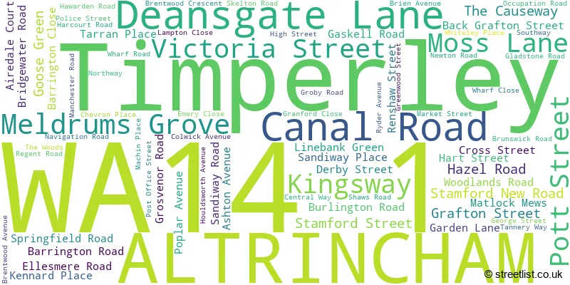
The largest settlements in the WA14 1 postal code are ALTRINCHAM and Timperley.
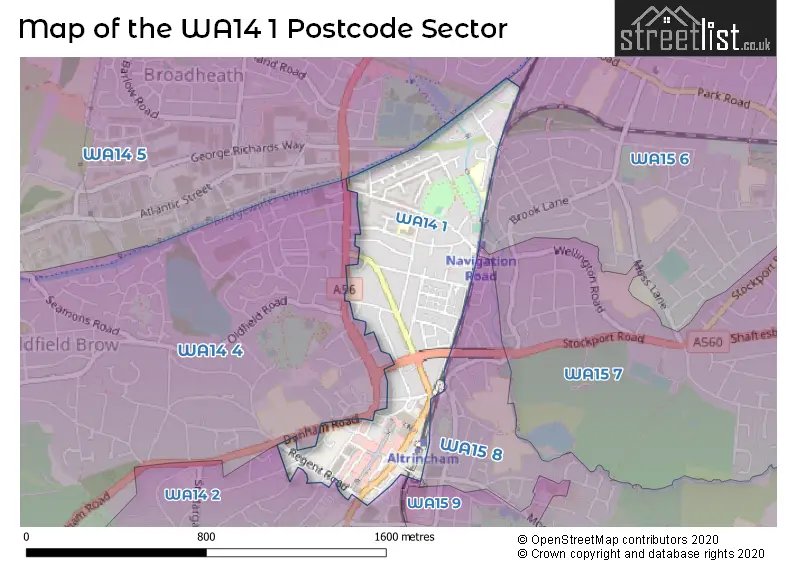
The WA14 1 Postcode shares a border with WA14 2 (ALTRINCHAM, Bowdon, Hale), WA14 4 (ALTRINCHAM, Broadheath, Little Bollington), WA15 6 (Timperley), WA14 5 (Broadheath, West Timperley, Timperley), WA15 7 (Timperley), WA15 8 (Hale, ALTRINCHAM, Hale Barns) and WA15 9 (Hale, ALTRINCHAM).
The sector is within the post town of ALTRINCHAM.
WA14 1 is a postcode sector within the WA14 postcode district which is within the WA Warrington postcode area.
The Royal Mail delivery office for the WA14 1 postal sector is the Altrincham Delivery Office.
The area of the WA14 1 postcode sector is 0.30 square miles which is 0.78 square kilometres or 192.46 square acres.
Waterways within the WA14 1 postcode sector include the Bridgewater Canal.

Map of the WA14 1 Postcode Sector
Explore the WA14 1 postcode sector by using our free interactive map.
| W | A | 1 | 4 | - | 1 | X | X |
| W | A | 1 | 4 | Space | 1 | Letter | Letter |
Official List of Streets
ALTRINCHAM (65 Streets)
Unofficial Streets or Alternative Spellings
Timperley
WELLINGTON ROADALTRINCHAM
BENTINCK ROAD GROBY PLACE HIGH BANK LLOYD SQUARE NEW STREET RAILWAY STREET SYLVAN GROVE ALBERT STREET ALTRINCHAM INTERCHANGE ALTRINCHAM STATION FOOTBRIDGE BREWERY STREET BRIDGE PLACE BRIDGEWATER WAY EARNEY STREET LYNGARTH HOUSE MAIN ROUTE MILL STREET MOUNT TERRACE NORMANS PLACE ROBERT SALT COURT SECONDRAY ROUTE STAMFORD PASSAGE STAMFORD WAY STOCKPORT ROAD FOOTBRIDGE WOOD STREETBroadheath
MANCHESTER ROAD RUTLAND ROADHale
MOSS LANEBowdon
DUNHAM ROAD GROBY ROADWeather Forecast for WA14 1
Press Button to Show Forecast for Altrincham
| Time Period | Icon | Description | Temperature | Rain Probability | Wind |
|---|---|---|---|---|---|
| 03:00 to 06:00 | Cloudy | 5.0°C (feels like 3.0°C) | 7.00% | NE 7 mph | |
| 06:00 to 09:00 | Cloudy | 5.0°C (feels like 3.0°C) | 6.00% | NE 7 mph | |
| 09:00 to 12:00 | Cloudy | 8.0°C (feels like 6.0°C) | 6.00% | ENE 9 mph | |
| 12:00 to 15:00 | Overcast | 10.0°C (feels like 8.0°C) | 16.00% | ENE 9 mph | |
| 15:00 to 18:00 | Overcast | 10.0°C (feels like 7.0°C) | 15.00% | ENE 9 mph | |
| 18:00 to 21:00 | Cloudy | 9.0°C (feels like 7.0°C) | 9.00% | ENE 9 mph | |
| 21:00 to 00:00 | Cloudy | 7.0°C (feels like 5.0°C) | 4.00% | NE 9 mph |
Press Button to Show Forecast for Altrincham
| Time Period | Icon | Description | Temperature | Rain Probability | Wind |
|---|---|---|---|---|---|
| 00:00 to 03:00 | Cloudy | 6.0°C (feels like 4.0°C) | 4.00% | NE 7 mph | |
| 03:00 to 06:00 | Cloudy | 6.0°C (feels like 3.0°C) | 7.00% | NNE 9 mph | |
| 06:00 to 09:00 | Cloudy | 6.0°C (feels like 3.0°C) | 14.00% | N 9 mph | |
| 09:00 to 12:00 | Light rain | 7.0°C (feels like 5.0°C) | 47.00% | NNW 9 mph | |
| 12:00 to 15:00 | Overcast | 9.0°C (feels like 7.0°C) | 19.00% | NW 9 mph | |
| 15:00 to 18:00 | Cloudy | 11.0°C (feels like 8.0°C) | 13.00% | WNW 11 mph | |
| 18:00 to 21:00 | Sunny day | 10.0°C (feels like 8.0°C) | 4.00% | W 9 mph | |
| 21:00 to 00:00 | Clear night | 7.0°C (feels like 6.0°C) | 2.00% | SW 7 mph |
Press Button to Show Forecast for Altrincham
| Time Period | Icon | Description | Temperature | Rain Probability | Wind |
|---|---|---|---|---|---|
| 00:00 to 03:00 | Clear night | 6.0°C (feels like 4.0°C) | 2.00% | S 7 mph | |
| 03:00 to 06:00 | Clear night | 5.0°C (feels like 2.0°C) | 1.00% | SSE 7 mph | |
| 06:00 to 09:00 | Sunny day | 6.0°C (feels like 3.0°C) | 2.00% | SSE 9 mph | |
| 09:00 to 12:00 | Partly cloudy (day) | 11.0°C (feels like 8.0°C) | 2.00% | S 11 mph | |
| 12:00 to 15:00 | Overcast | 13.0°C (feels like 10.0°C) | 11.00% | S 13 mph | |
| 15:00 to 18:00 | Overcast | 14.0°C (feels like 11.0°C) | 10.00% | S 13 mph | |
| 18:00 to 21:00 | Cloudy | 13.0°C (feels like 11.0°C) | 8.00% | SSE 11 mph | |
| 21:00 to 00:00 | Partly cloudy (night) | 11.0°C (feels like 9.0°C) | 3.00% | SSE 9 mph |
Press Button to Show Forecast for Altrincham
| Time Period | Icon | Description | Temperature | Rain Probability | Wind |
|---|---|---|---|---|---|
| 00:00 to 03:00 | Partly cloudy (night) | 9.0°C (feels like 7.0°C) | 3.00% | SE 9 mph | |
| 03:00 to 06:00 | Partly cloudy (night) | 9.0°C (feels like 6.0°C) | 2.00% | ESE 9 mph | |
| 06:00 to 09:00 | Sunny day | 9.0°C (feels like 7.0°C) | 2.00% | ESE 9 mph | |
| 09:00 to 12:00 | Partly cloudy (day) | 13.0°C (feels like 10.0°C) | 4.00% | ESE 13 mph | |
| 12:00 to 15:00 | Partly cloudy (day) | 15.0°C (feels like 12.0°C) | 7.00% | SE 13 mph | |
| 15:00 to 18:00 | Cloudy | 16.0°C (feels like 14.0°C) | 12.00% | SE 11 mph | |
| 18:00 to 21:00 | Partly cloudy (day) | 15.0°C (feels like 13.0°C) | 11.00% | ESE 9 mph | |
| 21:00 to 00:00 | Partly cloudy (night) | 12.0°C (feels like 11.0°C) | 4.00% | ESE 9 mph |
Schools and Places of Education Within the WA14 1 Postcode Sector
Navigation Primary School
Community school
Hawarden Road, Altrincham, Cheshire, WA14 1NG
Head: Ms Joanne Patterson
Ofsted Rating: Good
Inspection: 2020-02-05 (1543 days ago)
Website: Visit Navigation Primary School Website
Phone: 01619125937
Number of Pupils: 446
Trafford Alternative Education Provision
Pupil referral unit
Brentwood Avenue, Altrincham, , WA14 1SR
Head: Ms Linda Thompson
Ofsted Rating: Good
Inspection: 2019-07-02 (1761 days ago)
Website: Visit Trafford Alternative Education Provision Website
Phone: 01619121479
Number of Pupils: 39
House Prices in the WA14 1 Postcode Sector
| Type of Property | 2018 Average | 2018 Sales | 2017 Average | 2017 Sales | 2016 Average | 2016 Sales | 2015 Average | 2015 Sales |
|---|---|---|---|---|---|---|---|---|
| Detached | £502,157 | 5 | £486,750 | 2 | £572,143 | 7 | £328,490 | 5 |
| Semi-Detached | £312,420 | 19 | £375,513 | 32 | £335,378 | 18 | £274,187 | 27 |
| Terraced | £311,745 | 36 | £299,120 | 27 | £268,700 | 41 | £246,126 | 51 |
| Flats | £151,885 | 27 | £153,847 | 45 | £162,075 | 43 | £134,696 | 51 |
Important Postcodes WA14 1 in the Postcode Sector
WA14 1EJ is the postcode for Trafford Metropolitan Borough Council, Altrincham Library, 20 Stamford New Road
WA14 1EN is the postcode for Altrincham Interchange, Stamford New Road
WA14 1HZ is the postcode for Greater Manchester Police, Altrincham Police Station, Barrington Road
WA14 1NG is the postcode for Navigation Primary School, Hawarden Road
WA14 1PE is the postcode for Trafford Healthcare NHS Trust, Altrincham General Hospital
WA14 1PF is the postcode for Town Hall, Market Street
WA14 1RF is the postcode for Bricklayers Arms, 68 George Street
WA14 1SR is the postcode for Trafford Metropolitan Borough Council, Brentwood School, Brentwood Avenue, and Trafford Alternative Education Provision, (Incorporating Trafford High School and Trafford Medical Education Service), Brentwood Avenue
| The WA14 1 Sector is within these Local Authorities |
|
|---|---|
| The WA14 1 Sector is within these Counties |
|
| The WA14 1 Sector is within these Water Company Areas |
|