The WA7 6 postcode sector is within the county of Cheshire.
Did you know? According to the 2021 Census, the WA7 6 postcode sector is home to a bustling 15,124 residents!
Given that each sector allows for 400 unique postcode combinations. Letters C, I, K, M, O and V are not allowed in the last two letters of a postcode. With 231 postcodes already in use, this leaves 169 units available.
The largest settlement in the WA7 6 postal code is Murdishaw followed by Brookvale, and Windmill Hill.
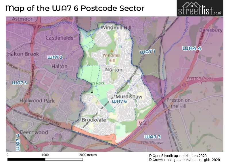
The WA7 6 Postcode shares a border with WA7 1 (RUNCORN, Astmoor Industrial Estate, Manor Park), WA7 2 (Castlefields, Palacefields, RUNCORN) and WA7 3 (Beechwood, Sutton Weaver, Preston Brook).
The sector is within the post town of RUNCORN.
WA7 6 is a postcode sector within the WA7 postcode district which is within the WA Warrington postcode area.
The Royal Mail delivery office for the WA7 6 postal sector is the Runcorn Delivery Office.
The area of the WA7 6 postcode sector is 1.84 square miles which is 4.77 square kilometres or 1,179.41 square acres.
The WA7 6 postcode sector is crossed by the M56 motorway.
Waterways within the WA7 6 postcode sector include the Bridgewater Canal - Runcorn Branch.

Map of the WA7 6 Postcode Sector
Explore the WA7 6 postcode sector by using our free interactive map.
| W | A | 7 | - | 6 | X | X |
| W | A | 7 | Space | 6 | Letter | Letter |
Official List of Streets
Norton (35 Streets)
Brookvale (49 Streets)
Windmill Hill (34 Streets)
RUNCORN (15 Streets)
Murdishaw (65 Streets)
Halton (1 Streets)
Unofficial Streets or Alternative Spellings
Castlefields
CASTLEFIELDS AVENUE EAST CORN BROOK AVENUE GLENDALE ROAD WORSLEY CLOSEDaresbury
CHESTER ROAD RED BROW LANEHalton
NORTON LANEPalacefields
SPARROWHAWK CLOSEWeather Forecast for WA7 6
Press Button to Show Forecast for Runcorn Ski Centre
| Time Period | Icon | Description | Temperature | Rain Probability | Wind |
|---|---|---|---|---|---|
| 12:00 to 15:00 | Partly cloudy (day) | 21.0°C (feels like 19.0°C) | 0.00% | SE 11 mph | |
| 15:00 to 18:00 | Cloudy | 22.0°C (feels like 20.0°C) | 3.00% | SE 11 mph | |
| 18:00 to 21:00 | Cloudy | 21.0°C (feels like 19.0°C) | 3.00% | ESE 9 mph | |
| 21:00 to 00:00 | Cloudy | 18.0°C (feels like 16.0°C) | 4.00% | ESE 11 mph |
Press Button to Show Forecast for Runcorn Ski Centre
| Time Period | Icon | Description | Temperature | Rain Probability | Wind |
|---|---|---|---|---|---|
| 00:00 to 03:00 | Cloudy | 16.0°C (feels like 14.0°C) | 3.00% | SE 11 mph | |
| 03:00 to 06:00 | Cloudy | 14.0°C (feels like 13.0°C) | 3.00% | E 7 mph | |
| 06:00 to 09:00 | Cloudy | 14.0°C (feels like 14.0°C) | 3.00% | ESE 4 mph | |
| 09:00 to 12:00 | Cloudy | 18.0°C (feels like 16.0°C) | 3.00% | SE 9 mph | |
| 12:00 to 15:00 | Cloudy | 21.0°C (feels like 19.0°C) | 10.00% | SE 11 mph | |
| 15:00 to 18:00 | Light rain shower (day) | 22.0°C (feels like 20.0°C) | 39.00% | SE 11 mph | |
| 18:00 to 21:00 | Light rain shower (day) | 20.0°C (feels like 19.0°C) | 41.00% | SSE 7 mph | |
| 21:00 to 00:00 | Light rain shower (night) | 17.0°C (feels like 16.0°C) | 34.00% | SE 7 mph |
Press Button to Show Forecast for Runcorn Ski Centre
| Time Period | Icon | Description | Temperature | Rain Probability | Wind |
|---|---|---|---|---|---|
| 00:00 to 03:00 | Partly cloudy (night) | 15.0°C (feels like 15.0°C) | 13.00% | SSW 7 mph | |
| 03:00 to 06:00 | Partly cloudy (night) | 14.0°C (feels like 13.0°C) | 10.00% | S 7 mph | |
| 06:00 to 09:00 | Overcast | 13.0°C (feels like 12.0°C) | 13.00% | S 7 mph | |
| 09:00 to 12:00 | Cloudy | 15.0°C (feels like 13.0°C) | 11.00% | SSE 11 mph | |
| 12:00 to 15:00 | Cloudy | 17.0°C (feels like 14.0°C) | 17.00% | SSE 13 mph | |
| 15:00 to 18:00 | Cloudy | 17.0°C (feels like 14.0°C) | 21.00% | SSE 13 mph | |
| 18:00 to 21:00 | Light rain | 15.0°C (feels like 13.0°C) | 57.00% | SE 13 mph | |
| 21:00 to 00:00 | Heavy rain | 14.0°C (feels like 12.0°C) | 79.00% | SE 11 mph |
Press Button to Show Forecast for Runcorn Ski Centre
| Time Period | Icon | Description | Temperature | Rain Probability | Wind |
|---|---|---|---|---|---|
| 00:00 to 03:00 | Heavy rain | 13.0°C (feels like 12.0°C) | 76.00% | SE 11 mph | |
| 03:00 to 06:00 | Light rain | 13.0°C (feels like 11.0°C) | 54.00% | SE 9 mph | |
| 06:00 to 09:00 | Light rain | 12.0°C (feels like 11.0°C) | 49.00% | SE 9 mph | |
| 09:00 to 12:00 | Light rain | 14.0°C (feels like 12.0°C) | 51.00% | SSE 11 mph | |
| 12:00 to 15:00 | Light rain shower (day) | 16.0°C (feels like 14.0°C) | 43.00% | SSE 11 mph | |
| 15:00 to 18:00 | Heavy rain shower (day) | 17.0°C (feels like 14.0°C) | 59.00% | SSE 11 mph | |
| 18:00 to 21:00 | Light rain shower (day) | 16.0°C (feels like 14.0°C) | 40.00% | SSE 9 mph | |
| 21:00 to 00:00 | Partly cloudy (night) | 13.0°C (feels like 12.0°C) | 11.00% | SSE 9 mph |
Press Button to Show Forecast for Runcorn Ski Centre
| Time Period | Icon | Description | Temperature | Rain Probability | Wind |
|---|---|---|---|---|---|
| 00:00 to 03:00 | Clear night | 12.0°C (feels like 10.0°C) | 5.00% | SSE 9 mph | |
| 03:00 to 06:00 | Partly cloudy (night) | 11.0°C (feels like 9.0°C) | 5.00% | SSE 9 mph | |
| 06:00 to 09:00 | Sunny day | 12.0°C (feels like 10.0°C) | 6.00% | SSE 9 mph | |
| 09:00 to 12:00 | Light rain shower (day) | 14.0°C (feels like 12.0°C) | 34.00% | SSE 11 mph | |
| 12:00 to 15:00 | Light rain shower (day) | 16.0°C (feels like 14.0°C) | 39.00% | SSE 11 mph | |
| 15:00 to 18:00 | Heavy rain shower (day) | 16.0°C (feels like 14.0°C) | 56.00% | S 11 mph | |
| 18:00 to 21:00 | Light rain shower (day) | 16.0°C (feels like 14.0°C) | 40.00% | S 9 mph | |
| 21:00 to 00:00 | Clear night | 13.0°C (feels like 12.0°C) | 7.00% | S 7 mph |
Schools and Places of Education Within the WA7 6 Postcode Sector
Brookvale Primary School
Community school
Northwich Road, Runcorn, Cheshire, WA7 6BZ
Head: Mr Rob Moore
Ofsted Rating: Outstanding
Inspection: 2013-01-25 (4124 days ago)
Website: Visit Brookvale Primary School Website
Phone: 01928711401
Number of Pupils: 253
Gorsewood Primary School
Community school
Gorsewood Road, Runcorn, Cheshire, WA7 6ES
Head: Miss Emma Jackson
Ofsted Rating: Good
Inspection: 2023-05-25 (352 days ago)
Website: Visit Gorsewood Primary School Website
Phone: 01928712100
Number of Pupils: 180
Murdishaw West Community Primary School
Community school
Barnfield Avenue, Runcorn, Cheshire, WA7 6EP
Head: Mrs Vanessa Edwards
Ofsted Rating: Good
Inspection: 2023-03-08 (430 days ago)
Website: Visit Murdishaw West Community Primary School Website
Phone: 01928711254
Number of Pupils: 131
Ormiston Bolingbroke Academy
Academy sponsor led
Barnfield Avenue, Runcorn, Cheshire, WA7 6EP
Head: Mrs Kathryn Evans
Ofsted Rating: Requires improvement
Inspection: 2023-05-11 (366 days ago)
Website: Visit Ormiston Bolingbroke Academy Website
Phone: 01928711643
Number of Pupils: 1011
St Berteline's CofE Primary School
Voluntary aided school
Norton Lane, Runcorn, Cheshire, WA7 6QN
Head: Mrs Sheridan Moss
Ofsted Rating: Good
Inspection: 2020-02-26 (1536 days ago)
Website: Visit St Berteline's CofE Primary School Website
Phone: 01928719847
Number of Pupils: 285
St Martin's Catholic Primary School
Voluntary aided school
St Martin's Lane, Runcorn, Cheshire, WA7 6HZ
Head: Mrs Catherine Ming
Ofsted Rating: Requires improvement
Inspection: 2023-07-19 (297 days ago)
Website: Visit St Martin's Catholic Primary School Website
Phone: 01928711207
Number of Pupils: 199
Windmill Hill Primary School
Community school
Windmill Hill, Runcorn, Cheshire, WA7 6QE
Head: Miss Paula Newman
Ofsted Rating: Outstanding
Inspection: 2013-07-03 (3965 days ago)
Website: Visit Windmill Hill Primary School Website
Phone: 01928712337
Number of Pupils: 159
House Prices in the WA7 6 Postcode Sector
| Type of Property | 2018 Average | 2018 Sales | 2017 Average | 2017 Sales | 2016 Average | 2016 Sales | 2015 Average | 2015 Sales |
|---|---|---|---|---|---|---|---|---|
| Detached | £213,153 | 48 | £212,756 | 59 | £199,535 | 50 | £198,284 | 55 |
| Semi-Detached | £119,491 | 35 | £122,136 | 40 | £108,298 | 24 | £110,060 | 24 |
| Terraced | £88,520 | 58 | £76,603 | 51 | £78,761 | 59 | £74,864 | 42 |
| Flats | £42,000 | 1 | £71,000 | 2 | £37,000 | 2 | £50,500 | 1 |
Important Postcodes WA7 6 in the Postcode Sector
WA7 6BJ is the postcode for Brookvale Children's Centre, Woodhatch Road, Brookvale, Brookvale Childrens Centre, Woodhatch Road, and Brookvale Children's Centre, Woodhatch Road
WA7 6BZ is the postcode for Brookvale Primary, Northwich Road, and Brookvale Primary School, Northwich Road
WA7 6EP is the postcode for Murdishaw West Cp School, Barnfield Avenue, Murdishaw, Halton High School, Barnfield Avenue, Murdishaw West Cp School, Barnfield Avenue, ORMISTON BOLLINGBROKE ACADEMY, Halton High School, Barnfield Avenue, and Brookvale Recreation Centre, Barnfield Avenue
WA7 6ES is the postcode for Murdishaw Health Centre, Gorsewood Road, Gorsewood Cp School, Gorsewood Road, Murdishaw, and Gorsewood Cp School, Gorsewood Road
WA7 6HZ is the postcode for St. Martins RC Primary School, St. Martins Lane, Murdishaw, and St. Martins RC Primary School, St. Martins Lane
WA7 6JW is the postcode for Murdishaw Play Building, Barnfield Avenue
WA7 6QE is the postcode for Windmill Hill Cp School, Norton Hill, Windmill Hill Cp School, Norton Hill, Windmill Hill, and The Play Centre, Norton Hill
WA7 6QN is the postcode for St. Bertelines Primary School, Norton Lane, Norton, and St. Bertelines Primary School, Norton Lane
| The WA7 6 Sector is within these Local Authorities |
|
|---|---|
| The WA7 6 Sector is within these Counties |
|
| The WA7 6 Sector is within these Water Company Areas |
|