The WF1 2 postcode sector is within the county of West Yorkshire.
Did you know? According to the 2021 Census, the WF1 2 postcode sector is home to a bustling 10,278 residents!
Given that each sector allows for 400 unique postcode combinations. Letters C, I, K, M, O and V are not allowed in the last two letters of a postcode. With 268 postcodes already in use, this leaves 132 units available.
The largest settlements in the WF1 2 postal code are WAKEFIELD and Outwood.
The WF1 2 Postcode shares a border with WF1 1 (WAKEFIELD), WF1 3 (WAKEFIELD, Outwood), WF2 9 (WAKEFIELD, Alverthorpe), WF3 3 (Lofthouse, Robin Hood, Thorpe) and WF2 0 (WAKEFIELD, Wrenthorpe, Kirkhamgate).
The sector is within the post town of WAKEFIELD.
WF1 2 is a postcode sector within the WF1 postcode district which is within the WF Wakefield postcode area.
The Royal Mail delivery office for the WF1 2 postal sector is the Wakefield Delivery Office.
The area of the WF1 2 postcode sector is 1.18 square miles which is 3.05 square kilometres or 753.63 square acres.

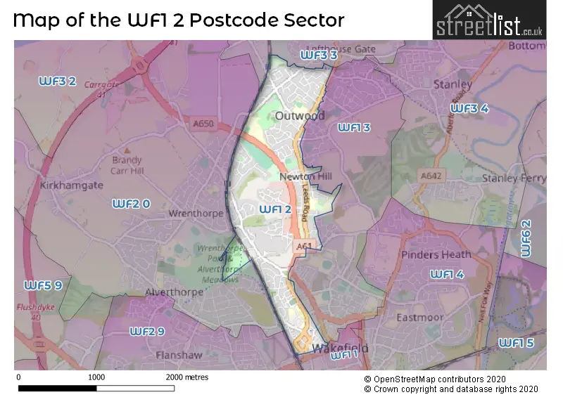
Map of the WF1 2 Postcode Sector
Explore the WF1 2 postcode sector by using our free interactive map.
| W | F | 1 | - | 2 | X | X |
| W | F | 1 | Space | 2 | Letter | Letter |
Official List of Streets
WAKEFIELD (150 Streets)
Outwood (18 Streets)
Newton Hill (1 Streets)
Unofficial Streets or Alternative Spellings
WAKEFIELD
ANDREW STREET BALNE LANE BAR LANE BELGRAVIA ROAD BOLUS LANE BOUNDARY DRIVE BUXTON PLACE CARTER STREET COACH ROAD CROSS STREET GEORGE & CROWN YARD GILLS YARD GREY STREET HEADINGLEY MEWS LABURNUM ROAD MOXON STREET NEWTON LANE NORTH ROAD TERRACE RISHWORTH STREET SPINNERS AVENUE WENTWORTH TERRACELofthouse
LEEDS ROAD LINGWELL GATE LANE POTOVENS LANECarr Gate
BRADFORD ROADWrenthorpe
WRENTHORPE ROADWeather Forecast for WF1 2
Press Button to Show Forecast for Wakefield
| Time Period | Icon | Description | Temperature | Rain Probability | Wind |
|---|---|---|---|---|---|
| 06:00 to 09:00 | Partly cloudy (day) | 3.0°C (feels like 1.0°C) | 2.00% | N 4 mph | |
| 09:00 to 12:00 | Cloudy | 7.0°C (feels like 5.0°C) | 6.00% | ENE 4 mph | |
| 12:00 to 15:00 | Cloudy | 8.0°C (feels like 7.0°C) | 11.00% | E 4 mph | |
| 15:00 to 18:00 | Cloudy | 9.0°C (feels like 8.0°C) | 9.00% | ENE 4 mph | |
| 18:00 to 21:00 | Cloudy | 7.0°C (feels like 5.0°C) | 8.00% | E 7 mph | |
| 21:00 to 00:00 | Cloudy | 5.0°C (feels like 4.0°C) | 7.00% | E 4 mph |
Press Button to Show Forecast for Wakefield
| Time Period | Icon | Description | Temperature | Rain Probability | Wind |
|---|---|---|---|---|---|
| 00:00 to 03:00 | Partly cloudy (night) | 4.0°C (feels like 2.0°C) | 4.00% | NE 4 mph | |
| 03:00 to 06:00 | Cloudy | 2.0°C (feels like 1.0°C) | 7.00% | NNE 4 mph | |
| 06:00 to 09:00 | Partly cloudy (day) | 3.0°C (feels like 1.0°C) | 7.00% | NE 4 mph | |
| 09:00 to 12:00 | Cloudy | 8.0°C (feels like 6.0°C) | 10.00% | E 7 mph | |
| 12:00 to 15:00 | Overcast | 10.0°C (feels like 8.0°C) | 17.00% | E 9 mph | |
| 15:00 to 18:00 | Overcast | 10.0°C (feels like 8.0°C) | 21.00% | ENE 9 mph | |
| 18:00 to 21:00 | Cloudy | 9.0°C (feels like 6.0°C) | 18.00% | ENE 9 mph | |
| 21:00 to 00:00 | Cloudy | 6.0°C (feels like 4.0°C) | 15.00% | NE 7 mph |
Press Button to Show Forecast for Wakefield
| Time Period | Icon | Description | Temperature | Rain Probability | Wind |
|---|---|---|---|---|---|
| 00:00 to 03:00 | Cloudy | 6.0°C (feels like 3.0°C) | 18.00% | NNE 9 mph | |
| 03:00 to 06:00 | Light rain | 6.0°C (feels like 3.0°C) | 49.00% | NNE 11 mph | |
| 06:00 to 09:00 | Light rain | 7.0°C (feels like 4.0°C) | 52.00% | NNE 11 mph | |
| 09:00 to 12:00 | Heavy rain | 8.0°C (feels like 5.0°C) | 79.00% | NNE 13 mph | |
| 12:00 to 15:00 | Light rain | 9.0°C (feels like 6.0°C) | 54.00% | NNE 13 mph | |
| 15:00 to 18:00 | Light rain shower (day) | 10.0°C (feels like 7.0°C) | 41.00% | N 11 mph | |
| 18:00 to 21:00 | Overcast | 9.0°C (feels like 7.0°C) | 19.00% | NNE 9 mph | |
| 21:00 to 00:00 | Partly cloudy (night) | 7.0°C (feels like 5.0°C) | 9.00% | SE 7 mph |
Schools and Places of Education Within the WF1 2 Postcode Sector
CAPA College
Free schools 16 to 19
Mulberry Way, Wakefield, West Yorkshire, WF1 2QN
Head: Ms Claire Nicholson
Ofsted Rating: Outstanding
Inspection: 2022-01-27 (820 days ago)
Website: Visit CAPA College Website
Phone: 01924583737
Number of Pupils: 335
Heart of Yorkshire Education Group
Further education
Margaret Street, Wakefield, West Yorkshire, WF1 2DH
Head: Ms Samantha Wright
Ofsted Rating: Good
Inspection: 2023-10-06 (203 days ago)
Website: Visit Heart of Yorkshire Education Group Website
Phone: 01924789789
Number of Pupils: 0
Newton Hill Community School
Community school
Leeds Road, Wakefield, West Yorkshire, WF1 2HR
Head: Mrs Caroline Wheatley
Ofsted Rating: Good
Inspection: 2019-05-10 (1813 days ago)
Website: Visit Newton Hill Community School Website
Phone: 01924303680
Number of Pupils: 277
Outwood Grange Academy
Academy sponsor led
Potovens Lane, Wakefield, West Yorkshire, WF1 2PF
Head: Mr Andrew Downing
Ofsted Rating: Outstanding
Inspection: 2012-02-09 (4460 days ago)
Website: Visit Outwood Grange Academy Website
Phone: 01924204350
Number of Pupils: 1995
Outwood Primary Academy Ledger Lane
Academy converter
Ledger Lane, Wakefield, West Yorkshire, WF1 2PH
Head: Mrs Rachael Skirrow
Ofsted Rating: Outstanding
Inspection: 2019-04-03 (1850 days ago)
Website: Visit Outwood Primary Academy Ledger Lane Website
Phone: 01924907430
Number of Pupils: 451
House Prices in the WF1 2 Postcode Sector
| Type of Property | 2018 Average | 2018 Sales | 2017 Average | 2017 Sales | 2016 Average | 2016 Sales | 2015 Average | 2015 Sales |
|---|---|---|---|---|---|---|---|---|
| Detached | £295,161 | 105 | £276,197 | 100 | £272,899 | 96 | £264,269 | 57 |
| Semi-Detached | £178,099 | 105 | £174,277 | 91 | £166,724 | 94 | £148,503 | 67 |
| Terraced | £153,335 | 107 | £137,779 | 90 | £115,201 | 48 | £110,238 | 64 |
| Flats | £119,184 | 19 | £106,274 | 40 | £110,387 | 38 | £93,544 | 56 |
Important Postcodes WF1 2 in the Postcode Sector
WF1 2DE is the postcode for Registry of Deeds, Newstead Road, and Beaumont Building, Wakefield City Campus, Newstead Road
WF1 2DH is the postcode for C BLOCK, Wakefield College, Margaret Street, ASIC BUILDING, Wakefield College, Margaret Street, D BLOCK, Wakefield College, Margaret Street, Gissing Building, Wakefield College, Margaret Street, A & B BLOCK, Wakefield College, Margaret Street, RADCLIFFE BUILDING, Wakefield College, Margaret Street, F BLOCK, Wakefield College, Margaret Street, NEW CATERING, Wakefield College, Margaret Street, HARRISON BUILDING, Wakefield College, Margaret Street, A BLOCK, Wakefield College, Margaret Street, and B BLOCK, Wakefield College, Margaret Street
WF1 2EB is the postcode for Wakefield One, Burton Street, and Wakefield Council, Wakefield One, Burton Street
WF1 2EW is the postcode for Wakefield College, Waterton Building, Wood Street, Wakefield College, Waterton Building, and Wakefield Museum, Wood Street
WF1 2HJ is the postcode for West Yorkshire Police, Police Station, Wood Street
WF1 2HQ is the postcode for Wakefield Town Hall, Wood St, Wakefield Town Hall, Wood Street, and City of Wakefield Metropolitan District Council, Town Hall, Wood Street
WF1 2HR is the postcode for Newton Hill Junior & Infant School, Leeds Road, Newton Hill J&I School, Leeds Road, and Newton Hill J&I School, Newton Hill J&I School, Leeds Road
WF1 2JL is the postcode for The St. Leger, 547 Leeds Road
WF1 2PF is the postcode for BT BLOCK, Outwood Grange College, Potovens Lane, RECEPTION BLOCK, Outwood Grange College, Potovens Lane, L BLOCK, Outwood Grange College, Potovens Lane, ARTS BLOCK, OUTWOOD GRANGE ACADEMY, POTOVENS LANE, SPORTS HALL & CHANGING BLOCK, Outwood Grange College, Potovens Lane, U BLOCK, OUTWOOD GRANGE ACADEMY, POTOVENS LANE, SPORTS HALL & CHANGING BLOCK, OUTWOOD GRANGE ACADEMY, POTOVENS LANE, S BLOCK, Outwood Grange College, Potovens Lane, L BLOCK, OUTWOOD GRANGE ACADEMY, POTOVENS LANE, ARTS BLOCK, Outwood Grange College, Potovens Lane, POST 16 BLOCK, Outwood Grange College, Potovens Lane, A BLOCK, Outwood Grange College, Potovens Lane, U BLOCK, Outwood Grange College, Potovens Lane, and S BLOCK, OUTWOOD GRANGE ACADEMY, POTOVENS LANE
WF1 2PH is the postcode for Outwood Primary Academy Ledger Lane, Ledger Lane, and Outwood Primary Academy, Ledger Lane
WF1 2QJ is the postcode for Newstead House, 11 Bond Street
WF1 2QL is the postcode for City of Wakefield Metropolitan District Council, County Hall, Bond Street, and County Hall, Bond Street
WF1 2QN is the postcode for Wakefield CJC, Emerald House, and Wakefield CJC, Emerald House, 1 Mulberry Way
WF1 2TW is the postcode for Clerk to the Justices, The Court House, Cliff Parade
WF1 2TX is the postcode for City of Wakefield Metropolitan District Council, Newton Bar
WF1 2UN is the postcode for City & Guilds, 4 Red Hall Court
| The WF1 2 Sector is within these Local Authorities |
|
|---|---|
| The WF1 2 Sector is within these Counties |
|
| The WF1 2 Sector is within these Water Company Areas |
|
Tourist Attractions within the WF1 2 Postcode Area
We found 1 visitor attractions within the WF1 postcode area
| Wakefield Museum |
|---|
| Museums & Art Galleries |
| Museum and / or Art Gallery |
| View Wakefield Museum on Google Maps |