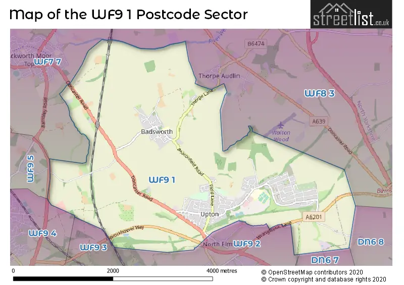
The WF9 1 postcode sector stands on the South Yorkshire and West Yorkshire border.
Did you know? According to the 2021 Census, the WF9 1 postcode sector is home to a bustling 7,189 residents!
Given that each sector allows for 400 unique postcode combinations. Letters C, I, K, M, O and V are not allowed in the last two letters of a postcode. With 177 postcodes already in use, this leaves 223 units available.
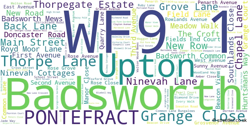
The largest settlement in the WF9 1 postal code is Upton followed by Badsworth, and PONTEFRACT.
The WF9 1 Postcode shares a border with WF9 4 (Hemsworth), WF9 3 (South Kirkby), WF7 7 (Ackworth), WF8 3 (PONTEFRACT, Darrington, Kirk Smeaton), WF9 2 (South Elmsall), WF9 5 (Fitzwilliam, Kinsley, Hemsworth), DN6 7 (Woodlands, Adwick-le-Street, Highfields) and DN6 8 (Carcroft, Skellow, DONCASTER).
The sector is within the post town of PONTEFRACT.
WF9 1 is a postcode sector within the WF9 postcode district which is within the WF Wakefield postcode area.
The Royal Mail delivery office for the WF9 1 postal sector is the Upton (wf) Scale Payment Delivery Office.
The area of the WF9 1 postcode sector is 6.22 square miles which is 16.10 square kilometres or 3,978.33 square acres.
Waterways within the WF9 1 postcode sector include the River Went.

Map of the WF9 1 Postcode Sector
Explore the WF9 1 postcode sector by using our free interactive map.
| W | F | 9 | - | 1 | X | X |
| W | F | 9 | Space | 1 | Letter | Letter |
Official List of Streets
Upton (90 Streets)
Badsworth (27 Streets)
PONTEFRACT (3 Streets)
Unofficial Streets or Alternative Spellings
Weather Forecast for WF9 1
Press Button to Show Forecast for South Elmsall
| Time Period | Icon | Description | Temperature | Rain Probability | Wind |
|---|---|---|---|---|---|
| 09:00 to 12:00 | Cloudy | 8.0°C (feels like 6.0°C) | 15.00% | NE 9 mph | |
| 12:00 to 15:00 | Overcast | 9.0°C (feels like 7.0°C) | 18.00% | ENE 9 mph | |
| 15:00 to 18:00 | Overcast | 9.0°C (feels like 6.0°C) | 16.00% | ENE 11 mph | |
| 18:00 to 21:00 | Cloudy | 8.0°C (feels like 6.0°C) | 9.00% | ENE 9 mph | |
| 21:00 to 00:00 | Cloudy | 6.0°C (feels like 4.0°C) | 8.00% | NE 7 mph |
Press Button to Show Forecast for South Elmsall
| Time Period | Icon | Description | Temperature | Rain Probability | Wind |
|---|---|---|---|---|---|
| 00:00 to 03:00 | Cloudy | 6.0°C (feels like 3.0°C) | 9.00% | N 9 mph | |
| 03:00 to 06:00 | Cloudy | 5.0°C (feels like 2.0°C) | 18.00% | N 9 mph | |
| 06:00 to 09:00 | Light rain | 6.0°C (feels like 2.0°C) | 55.00% | N 11 mph | |
| 09:00 to 12:00 | Light rain | 7.0°C (feels like 3.0°C) | 56.00% | NNW 11 mph | |
| 12:00 to 15:00 | Heavy rain | 8.0°C (feels like 5.0°C) | 72.00% | NW 11 mph | |
| 15:00 to 18:00 | Cloudy | 10.0°C (feels like 8.0°C) | 15.00% | WNW 9 mph | |
| 18:00 to 21:00 | Partly cloudy (day) | 10.0°C (feels like 8.0°C) | 7.00% | W 9 mph | |
| 21:00 to 00:00 | Clear night | 7.0°C (feels like 5.0°C) | 2.00% | WSW 7 mph |
Press Button to Show Forecast for South Elmsall
| Time Period | Icon | Description | Temperature | Rain Probability | Wind |
|---|---|---|---|---|---|
| 00:00 to 03:00 | Clear night | 6.0°C (feels like 4.0°C) | 1.00% | SW 7 mph | |
| 03:00 to 06:00 | Clear night | 5.0°C (feels like 3.0°C) | 1.00% | SSW 7 mph | |
| 06:00 to 09:00 | Sunny day | 6.0°C (feels like 3.0°C) | 1.00% | S 7 mph | |
| 09:00 to 12:00 | Sunny day | 10.0°C (feels like 8.0°C) | 1.00% | S 11 mph | |
| 12:00 to 15:00 | Partly cloudy (day) | 13.0°C (feels like 11.0°C) | 3.00% | S 13 mph | |
| 15:00 to 18:00 | Cloudy | 14.0°C (feels like 12.0°C) | 6.00% | S 13 mph | |
| 18:00 to 21:00 | Partly cloudy (day) | 13.0°C (feels like 11.0°C) | 2.00% | SSE 11 mph | |
| 21:00 to 00:00 | Clear night | 11.0°C (feels like 9.0°C) | 2.00% | SE 9 mph |
Press Button to Show Forecast for South Elmsall
| Time Period | Icon | Description | Temperature | Rain Probability | Wind |
|---|---|---|---|---|---|
| 00:00 to 03:00 | Clear night | 9.0°C (feels like 7.0°C) | 2.00% | SSE 9 mph | |
| 03:00 to 06:00 | Clear night | 7.0°C (feels like 5.0°C) | 2.00% | SE 7 mph | |
| 06:00 to 09:00 | Sunny day | 8.0°C (feels like 6.0°C) | 4.00% | ESE 7 mph | |
| 09:00 to 12:00 | Cloudy | 12.0°C (feels like 10.0°C) | 7.00% | ESE 9 mph | |
| 12:00 to 15:00 | Partly cloudy (day) | 15.0°C (feels like 13.0°C) | 7.00% | ESE 11 mph | |
| 15:00 to 18:00 | Cloudy | 16.0°C (feels like 13.0°C) | 12.00% | ESE 11 mph | |
| 18:00 to 21:00 | Cloudy | 14.0°C (feels like 13.0°C) | 12.00% | ESE 9 mph | |
| 21:00 to 00:00 | Cloudy | 12.0°C (feels like 10.0°C) | 10.00% | E 7 mph |
Schools and Places of Education Within the WF9 1 Postcode Sector
Badsworth Church of England Voluntary Controlled Junior and Infant School
Voluntary controlled school
Badsworth Ce J&I (Vc) School, Main Street, Pontefract, West Yorkshire, WF9 1AJ
Head: Miss Jenny Griffiths
Ofsted Rating: Good
Inspection: 2023-02-08 (444 days ago)
Website: Visit Badsworth Church of England Voluntary Controlled Junior and Infant School Website
Phone: 01977649157
Number of Pupils: 196
Upton Primary School
Community school
Waggon Lane, Pontefract, West Yorkshire, WF9 1JS
Head: Mrs Lynne Williamson
Ofsted Rating: Good
Inspection: 2022-10-19 (556 days ago)
Website: Visit Upton Primary School Website
Phone: 01977650820
Number of Pupils: 457
House Prices in the WF9 1 Postcode Sector
| Type of Property | 2018 Average | 2018 Sales | 2017 Average | 2017 Sales | 2016 Average | 2016 Sales | 2015 Average | 2015 Sales |
|---|---|---|---|---|---|---|---|---|
| Detached | £195,912 | 50 | £223,316 | 62 | £195,146 | 66 | £189,694 | 58 |
| Semi-Detached | £112,699 | 46 | £100,883 | 41 | £119,311 | 62 | £108,139 | 37 |
| Terraced | £107,194 | 27 | £78,785 | 24 | £98,342 | 35 | £102,196 | 28 |
| Flats | £0 | 0 | £0 | 0 | £0 | 0 | £0 | 0 |
Important Postcodes WF9 1 in the Postcode Sector
WF9 1AJ is the postcode for MAIN SCHOOL (BLOCK 1), Badsworth C of E Junior & Infant School, Main Street
WF9 1JS is the postcode for Upton Primary School, Waggon Lane, Upton, Greenview Medical Centre, Waggon Lane, and Upton Primary School, Waggon Lane
| The WF9 1 Sector is within these Local Authorities |
|
|---|---|
| The WF9 1 Sector is within these Counties |
|
| The WF9 1 Sector is within these Water Company Areas |
|