The WN3 4 postcode sector is within the county of Greater Manchester.
Did you know? According to the 2021 Census, the WN3 4 postcode sector is home to a bustling 6,068 residents!
Given that each sector allows for 400 unique postcode combinations. Letters C, I, K, M, O and V are not allowed in the last two letters of a postcode. With 201 postcodes already in use, this leaves 199 units available.
The largest settlements in the WN3 4 postal code are Ince and WIGAN.
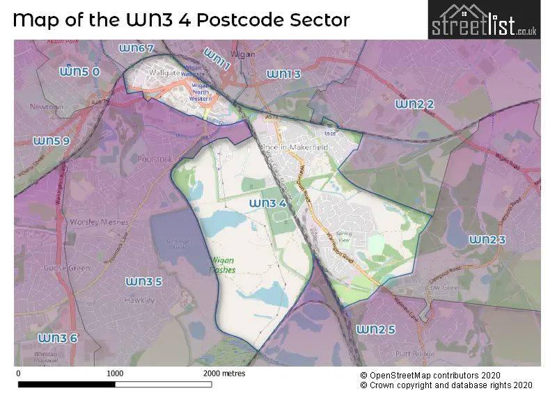
The WN3 4 Postcode shares a border with WN1 3 (WIGAN, Ince), WN2 2 (Ince, Hindley, Aspull), WN2 3 (Hindley, Platt Bridge), WN2 5 (Platt Bridge, Abram, Bamfurlong), WN3 5 (WIGAN, Worsley Mesnes), WN5 0 (WIGAN, Orrell, Martland Park), WN6 7 (WIGAN) and WN1 1 (WIGAN).
The sector is within the post town of WIGAN.
WN3 4 is a postcode sector within the WN3 postcode district which is within the WN Wigan postcode area.
The Royal Mail delivery office for the WN3 4 postal sector is the Wigan Delivery Office.
The area of the WN3 4 postcode sector is 1.61 square miles which is 4.17 square kilometres or 1,030.31 square acres.
Waterways within the WN3 4 postcode sector include the Leeds and Liverpool Canal (Leigh Branch), Leeds and Liverpool Canal, River Douglas.

Map of the WN3 4 Postcode Sector
Explore the WN3 4 postcode sector by using our free interactive map.
| W | N | 3 | - | 4 | X | X |
| W | N | 3 | Space | 4 | Letter | Letter |
Official List of Streets
Ince (106 Streets)
WIGAN (33 Streets)
Unofficial Streets or Alternative Spellings
WIGAN
POTTERY ROAD POTTERY TERRACE RIVER WAY SWAN MEADOW ROAD WESTWOOD WAYWeather Forecast for WN3 4
Press Button to Show Forecast for Ince-In-Makerfield
| Time Period | Icon | Description | Temperature | Rain Probability | Wind |
|---|---|---|---|---|---|
| 03:00 to 06:00 | Partly cloudy (night) | 5.0°C (feels like 2.0°C) | 1.00% | ENE 7 mph | |
| 06:00 to 09:00 | Partly cloudy (day) | 5.0°C (feels like 3.0°C) | 2.00% | ENE 7 mph | |
| 09:00 to 12:00 | Cloudy | 8.0°C (feels like 6.0°C) | 5.00% | E 9 mph | |
| 12:00 to 15:00 | Cloudy | 10.0°C (feels like 8.0°C) | 8.00% | E 7 mph | |
| 15:00 to 18:00 | Cloudy | 10.0°C (feels like 8.0°C) | 10.00% | NE 9 mph | |
| 18:00 to 21:00 | Cloudy | 9.0°C (feels like 7.0°C) | 9.00% | ENE 9 mph | |
| 21:00 to 00:00 | Cloudy | 8.0°C (feels like 6.0°C) | 5.00% | ENE 7 mph |
Press Button to Show Forecast for Ince-In-Makerfield
| Time Period | Icon | Description | Temperature | Rain Probability | Wind |
|---|---|---|---|---|---|
| 00:00 to 03:00 | Partly cloudy (night) | 6.0°C (feels like 4.0°C) | 1.00% | NE 7 mph | |
| 03:00 to 06:00 | Cloudy | 5.0°C (feels like 3.0°C) | 4.00% | N 7 mph | |
| 06:00 to 09:00 | Cloudy | 6.0°C (feels like 3.0°C) | 10.00% | N 7 mph | |
| 09:00 to 12:00 | Cloudy | 8.0°C (feels like 5.0°C) | 12.00% | NNW 9 mph | |
| 12:00 to 15:00 | Overcast | 10.0°C (feels like 7.0°C) | 15.00% | NW 9 mph | |
| 15:00 to 18:00 | Cloudy | 10.0°C (feels like 8.0°C) | 11.00% | WNW 11 mph | |
| 18:00 to 21:00 | Sunny day | 10.0°C (feels like 8.0°C) | 4.00% | W 9 mph | |
| 21:00 to 00:00 | Clear night | 8.0°C (feels like 6.0°C) | 2.00% | SW 7 mph |
Press Button to Show Forecast for Ince-In-Makerfield
| Time Period | Icon | Description | Temperature | Rain Probability | Wind |
|---|---|---|---|---|---|
| 00:00 to 03:00 | Partly cloudy (night) | 7.0°C (feels like 5.0°C) | 2.00% | S 7 mph | |
| 03:00 to 06:00 | Partly cloudy (night) | 6.0°C (feels like 3.0°C) | 2.00% | SSE 7 mph | |
| 06:00 to 09:00 | Cloudy | 6.0°C (feels like 3.0°C) | 5.00% | SSE 9 mph | |
| 09:00 to 12:00 | Partly cloudy (day) | 10.0°C (feels like 8.0°C) | 1.00% | SSE 11 mph | |
| 12:00 to 15:00 | Cloudy | 13.0°C (feels like 10.0°C) | 7.00% | S 13 mph | |
| 15:00 to 18:00 | Cloudy | 14.0°C (feels like 11.0°C) | 9.00% | S 13 mph | |
| 18:00 to 21:00 | Cloudy | 13.0°C (feels like 11.0°C) | 8.00% | SSE 13 mph | |
| 21:00 to 00:00 | Partly cloudy (night) | 11.0°C (feels like 9.0°C) | 3.00% | SSE 11 mph |
Press Button to Show Forecast for Ince-In-Makerfield
| Time Period | Icon | Description | Temperature | Rain Probability | Wind |
|---|---|---|---|---|---|
| 00:00 to 03:00 | Partly cloudy (night) | 10.0°C (feels like 7.0°C) | 3.00% | SE 9 mph | |
| 03:00 to 06:00 | Cloudy | 9.0°C (feels like 7.0°C) | 6.00% | SE 9 mph | |
| 06:00 to 09:00 | Partly cloudy (day) | 9.0°C (feels like 7.0°C) | 2.00% | ESE 11 mph | |
| 09:00 to 12:00 | Partly cloudy (day) | 13.0°C (feels like 10.0°C) | 3.00% | ESE 13 mph | |
| 12:00 to 15:00 | Cloudy | 15.0°C (feels like 12.0°C) | 9.00% | SE 13 mph | |
| 15:00 to 18:00 | Cloudy | 16.0°C (feels like 13.0°C) | 13.00% | SE 11 mph | |
| 18:00 to 21:00 | Light rain shower (day) | 15.0°C (feels like 13.0°C) | 31.00% | ESE 9 mph | |
| 21:00 to 00:00 | Partly cloudy (night) | 13.0°C (feels like 11.0°C) | 7.00% | E 9 mph |
Schools and Places of Education Within the WN3 4 Postcode Sector
Britannia Bridge Primary School
Community school
Winifred Street, Wigan, Lancashire, WN3 4SD
Head: Mrs Carol Pidgeon-Duncalf
Ofsted Rating: Good
Inspection: 2023-04-26 (367 days ago)
Website: Visit Britannia Bridge Primary School Website
Phone: 01942760036
Number of Pupils: 240
House Prices in the WN3 4 Postcode Sector
| Type of Property | 2018 Average | 2018 Sales | 2017 Average | 2017 Sales | 2016 Average | 2016 Sales | 2015 Average | 2015 Sales |
|---|---|---|---|---|---|---|---|---|
| Detached | £168,563 | 16 | £181,497 | 15 | £153,377 | 13 | £150,997 | 19 |
| Semi-Detached | £98,231 | 24 | £106,662 | 29 | £101,952 | 26 | £101,196 | 28 |
| Terraced | £74,150 | 30 | £77,422 | 23 | £77,168 | 36 | £65,388 | 33 |
| Flats | £74,240 | 13 | £86,538 | 13 | £69,142 | 12 | £61,417 | 6 |
Important Postcodes WN3 4 in the Postcode Sector
WN3 4BJ is the postcode for H M Revenue & Customs, Lingate House
WN3 4HE is the postcode for BLOCK B, Unity House, Westwood Park Drive
WN3 4HH is the postcode for BLOCK A, Progress House, Westwood Park Drive
WN3 4JH is the postcode for Britannia Bridge Primary School, Parliament Street
WN3 4JW is the postcode for Metrolite Industries, 60 Warrington Road
WN3 4NW is the postcode for Lower Ince Health Centre, Phoenix Way, Ince, and Lower Ince Health Centre, Phoenix Way
WN3 4QX is the postcode for Wigan Council, Town Hall, Ince Green Lane
WN3 4SD is the postcode for Britannia Bridge Primary School, Winifred Street
WN3 4TJ is the postcode for St Mary's C of E Primary School, Derby Street
| The WN3 4 Sector is within these Local Authorities |
|
|---|---|
| The WN3 4 Sector is within these Counties |
|
| The WN3 4 Sector is within these Water Company Areas |
|