The WR10 1 postcode sector is within the county of Worcestershire.
Did you know? According to the 2021 Census, the WR10 1 postcode sector is home to a bustling 7,590 residents!
Given that each sector allows for 400 unique postcode combinations. Letters C, I, K, M, O and V are not allowed in the last two letters of a postcode. With 211 postcodes already in use, this leaves 189 units available.
The WR10 1 postal code covers the settlement of PERSHORE.
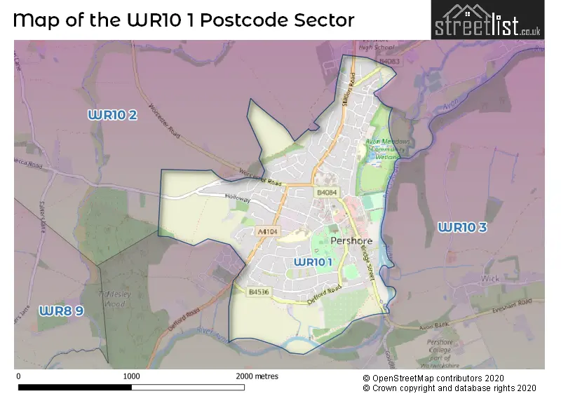
The WR10 1 Postcode shares a border with WR10 2 (Drakes Broughton, Pinvin, PERSHORE) and WR10 3 (Eckington, Cropthorne, PERSHORE).
The sector is within the post town of PERSHORE.
WR10 1 is a postcode sector within the WR10 postcode district which is within the WR Worcester postcode area.
The Royal Mail delivery office for the WR10 1 postal sector is the Pershore Delivery Office.
The area of the WR10 1 postcode sector is 1.22 square miles which is 3.16 square kilometres or 780.02 square acres.
Waterways within the WR10 1 postcode sector include the River Avon.

Map of the WR10 1 Postcode Sector
Explore the WR10 1 postcode sector by using our free interactive map.
| W | R | 1 | 0 | - | 1 | X | X |
| W | R | 1 | 0 | Space | 1 | Letter | Letter |
Official List of Streets
PERSHORE (122 Streets)
Unofficial Streets or Alternative Spellings
PERSHORE
DESJARDINS WAY ALTHORPE GARDENS AVON WAY BAGSHAW COURT BAKERS ARCADE CHOULES CLOSE CHURCH WALK COWLEYS WAY LITTLE PENNYROPE LUNNS YARD MILLSIDE BOATYARD MOUNT PLEASANT BARNS PERSHORE BRIDGE PERSHORE OLD BRIDGE QUAY STREET ROLAND RUTTER COURT SAINT ANDREWS ROAD ST AGATHAS COURT THE BOARD WALK WYCHAVON & AVON WAYSDrakes Broughton
WORCESTER ROADWeather Forecast for WR10 1
Press Button to Show Forecast for Pershore
| Time Period | Icon | Description | Temperature | Rain Probability | Wind |
|---|---|---|---|---|---|
| 00:00 to 03:00 | Overcast | 7.0°C (feels like 4.0°C) | 17.00% | ENE 9 mph | |
| 03:00 to 06:00 | Cloudy | 6.0°C (feels like 4.0°C) | 17.00% | ENE 9 mph | |
| 06:00 to 09:00 | Overcast | 6.0°C (feels like 3.0°C) | 21.00% | NE 9 mph | |
| 09:00 to 12:00 | Overcast | 7.0°C (feels like 4.0°C) | 22.00% | ENE 11 mph | |
| 12:00 to 15:00 | Light rain | 8.0°C (feels like 5.0°C) | 48.00% | ENE 11 mph | |
| 15:00 to 18:00 | Overcast | 9.0°C (feels like 7.0°C) | 16.00% | NE 11 mph | |
| 18:00 to 21:00 | Overcast | 9.0°C (feels like 6.0°C) | 12.00% | NE 11 mph | |
| 21:00 to 00:00 | Cloudy | 8.0°C (feels like 5.0°C) | 15.00% | NE 11 mph |
Press Button to Show Forecast for Pershore
| Time Period | Icon | Description | Temperature | Rain Probability | Wind |
|---|---|---|---|---|---|
| 00:00 to 03:00 | Light rain | 7.0°C (feels like 3.0°C) | 55.00% | NNE 11 mph | |
| 03:00 to 06:00 | Heavy rain | 6.0°C (feels like 3.0°C) | 76.00% | N 11 mph | |
| 06:00 to 09:00 | Heavy rain | 6.0°C (feels like 3.0°C) | 79.00% | N 11 mph | |
| 09:00 to 12:00 | Heavy rain | 7.0°C (feels like 4.0°C) | 76.00% | NNW 11 mph | |
| 12:00 to 15:00 | Light rain | 9.0°C (feels like 7.0°C) | 51.00% | NW 9 mph | |
| 15:00 to 18:00 | Cloudy | 11.0°C (feels like 10.0°C) | 12.00% | W 7 mph | |
| 18:00 to 21:00 | Cloudy | 11.0°C (feels like 9.0°C) | 8.00% | W 7 mph | |
| 21:00 to 00:00 | Clear night | 8.0°C (feels like 6.0°C) | 1.00% | SW 7 mph |
Press Button to Show Forecast for Pershore
| Time Period | Icon | Description | Temperature | Rain Probability | Wind |
|---|---|---|---|---|---|
| 00:00 to 03:00 | Clear night | 5.0°C (feels like 3.0°C) | 1.00% | SSW 7 mph | |
| 03:00 to 06:00 | Clear night | 5.0°C (feels like 2.0°C) | 1.00% | S 7 mph | |
| 06:00 to 09:00 | Sunny day | 7.0°C (feels like 4.0°C) | 1.00% | S 7 mph | |
| 09:00 to 12:00 | Partly cloudy (day) | 12.0°C (feels like 9.0°C) | 1.00% | S 13 mph | |
| 12:00 to 15:00 | Cloudy | 13.0°C (feels like 11.0°C) | 8.00% | S 13 mph | |
| 15:00 to 18:00 | Cloudy | 14.0°C (feels like 11.0°C) | 7.00% | S 13 mph | |
| 18:00 to 21:00 | Sunny day | 13.0°C (feels like 10.0°C) | 3.00% | S 11 mph | |
| 21:00 to 00:00 | Clear night | 10.0°C (feels like 7.0°C) | 2.00% | SSE 9 mph |
Press Button to Show Forecast for Pershore
| Time Period | Icon | Description | Temperature | Rain Probability | Wind |
|---|---|---|---|---|---|
| 00:00 to 03:00 | Clear night | 9.0°C (feels like 6.0°C) | 3.00% | SE 9 mph | |
| 03:00 to 06:00 | Clear night | 8.0°C (feels like 6.0°C) | 1.00% | SE 9 mph | |
| 06:00 to 09:00 | Sunny day | 9.0°C (feels like 7.0°C) | 2.00% | ESE 9 mph | |
| 09:00 to 12:00 | Sunny day | 13.0°C (feels like 11.0°C) | 5.00% | SE 11 mph | |
| 12:00 to 15:00 | Partly cloudy (day) | 16.0°C (feels like 13.0°C) | 10.00% | SE 13 mph | |
| 15:00 to 18:00 | Cloudy | 16.0°C (feels like 14.0°C) | 14.00% | SE 11 mph | |
| 18:00 to 21:00 | Partly cloudy (day) | 15.0°C (feels like 13.0°C) | 10.00% | SE 9 mph | |
| 21:00 to 00:00 | Partly cloudy (night) | 11.0°C (feels like 10.0°C) | 6.00% | ESE 7 mph |
Schools and Places of Education Within the WR10 1 Postcode Sector
Abbey Park First and Nursery School
Community school
Abbey Road, Pershore, Worcestershire, WR10 1DF
Head: Miss Rebecca Scully
Ofsted Rating: Good
Inspection: 2023-03-03 (421 days ago)
Website: Visit Abbey Park First and Nursery School Website
Phone: 01386552722
Number of Pupils: 187
Abbey Park Middle School
Community school
Abbey Road, Pershore, Worcestershire, WR10 1DF
Head: Ms Rebecca Scully
Ofsted Rating: Good
Inspection: 2022-06-29 (668 days ago)
Website: Visit Abbey Park Middle School Website
Phone: 01386552667
Number of Pupils: 107
Holy Redeemer Catholic Primary School
Voluntary aided school
Priest Lane, Pershore, Worcestershire, WR10 1EB
Head: Mrs C Hall
Ofsted Rating: Good
Inspection: 2023-01-25 (458 days ago)
Website: Visit Holy Redeemer Catholic Primary School Website
Phone: 01386552518
Number of Pupils: 167
Orchard Primary School
Academy converter
Cherry Orchard, Pershore, Worcestershire, WR10 1ET
Head: Mrs Sarah Bitcon
Ofsted Rating: Good
Inspection: 2022-01-12 (836 days ago)
Website: Visit Orchard Primary School Website
Phone: 01386552515
Number of Pupils: 198
House Prices in the WR10 1 Postcode Sector
| Type of Property | 2018 Average | 2018 Sales | 2017 Average | 2017 Sales | 2016 Average | 2016 Sales | 2015 Average | 2015 Sales |
|---|---|---|---|---|---|---|---|---|
| Detached | £315,986 | 79 | £301,073 | 54 | £301,852 | 63 | £282,581 | 33 |
| Semi-Detached | £205,968 | 67 | £208,087 | 43 | £198,144 | 51 | £186,403 | 33 |
| Terraced | £176,671 | 29 | £226,622 | 27 | £189,214 | 28 | £174,377 | 35 |
| Flats | £179,257 | 14 | £204,624 | 45 | £169,489 | 9 | £107,419 | 13 |
Important Postcodes WR10 1 in the Postcode Sector
WR10 1DF is the postcode for Abbey Park First & Nursery School, Abbey Road, and Abbey Park Middle School, Abbey Road
WR10 1EB is the postcode for Holy Redeemer Primary School, Priest Lane
WR10 1ET is the postcode for Cherry Orchard First School, Cherry Orchard, and Orchard Primary & Pre-School, Cherry Orchard
WR10 1JP is the postcode for Abbey Park First School, Abbey Road
WR10 1PS is the postcode for Worcestershire PCT, Pershore Hospital, Herefordshire & Worcestershire Health & Care NHS Trust, Pershore Hospital, Queen Elizabeth House, Queen Elizabeth Drive, Pershore Hospital, Queen Elizabeth House, Queen Elizabeth Drive, and Worcestershire Health and Care NHS Trust, QUEEN ELIZABETH HOUSE, QUEEN ELIZABETH DRIVE
WR10 1PT is the postcode for Civic Centre, Queen Elizabeth Drive
WR10 1QU is the postcode for Pershore Leisure Centre, King Georges Way
| The WR10 1 Sector is within these Local Authorities |
|
|---|---|
| The WR10 1 Sector is within these Counties |
|
| The WR10 1 Sector is within these Water Company Areas |
|