The WR7 4 postcode sector stands on the Warwickshire and Worcestershire border.
Did you know? According to the 2021 Census, the WR7 4 postcode sector is home to a bustling 5,737 residents!
Given that each sector allows for 400 unique postcode combinations. Letters C, I, K, M, O and V are not allowed in the last two letters of a postcode. With 214 postcodes already in use, this leaves 186 units available.
The largest settlement in the WR7 4 postal code is Inkberrow followed by Crowle, and Upton Snodsbury.
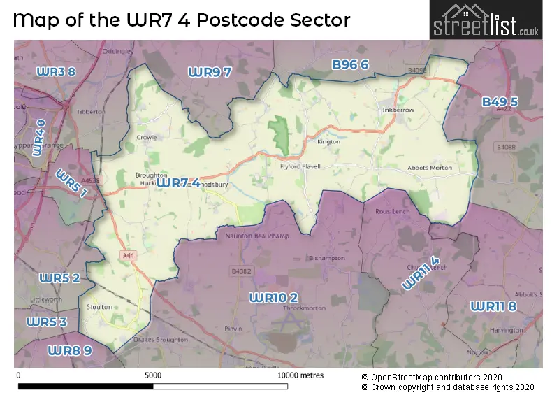
The WR7 4 Postcode shares a border with WR9 7 (DROITWICH, Wychbold, Copcut), WR8 9 (Severn Stoke, Defford, Earls Croome), B49 5 (ALCESTER, Cookhill, Kings Coughton), WR5 1 (WORCESTER, Whittington, Spetchley), WR5 2 (WORCESTER, Norton, Whittington), WR5 3 (WORCESTER, Kempsey, Broomhall), WR10 2 (Drakes Broughton, Pinvin, PERSHORE), WR11 4 (EVESHAM, Norton, Church Lench), WR11 8 (Harvington, Offenham, South Littleton) and B96 6 (Astwood Bank, Feckenham, Sambourne).
The sector is within the post town of WORCESTER.
WR7 4 is a postcode sector within the WR7 postcode district which is within the WR Worcester postcode area.
The Royal Mail delivery office for the WR7 4 postal sector is the Worcester Apc and Flyford Flavel Scale Payment Delivery Office and Inkberrow Scale Payment Delivery Office.
The area of the WR7 4 postcode sector is 29.16 square miles which is 75.52 square kilometres or 18,660.81 square acres.

Map of the WR7 4 Postcode Sector
Explore the WR7 4 postcode sector by using our free interactive map.
| W | R | 7 | - | 4 | X | X |
| W | R | 7 | Space | 4 | Letter | Letter |
Official List of Streets
Abbots Morton (3 Streets)
Churchill (1 Streets)
Flyford Flavell (6 Streets)
Inkberrow (44 Streets)
Kington (4 Streets)
Radford (2 Streets)
Crowle (24 Streets)
Upton Snodsbury (13 Streets)
Stoulton (12 Streets)
Dormston (4 Streets)
Sneachill (2 Streets)
White-Ladies-Aston (1 Streets)
Egdon (2 Streets)
Broughton Hackett (3 Streets)
Unofficial Streets or Alternative Spellings
Holberrow Green
BOUTS LANE BEECHCROFT GARDENS BOXBUSH DRIVE BROOKLYN COURT CHAPEL LANE CLAVERTON HILL FARM JENKINSON GARDENS MANOR COURT OWLS END LANE PRIORY FARM ROAD VILLAGE ROADRous Lench
RADFORD ROADPinvin
UPTON SNODSBURY ROADHindlip
PERSHORE LANEWeather Forecast for WR7 4
Press Button to Show Forecast for Upton Snodsbury
| Time Period | Icon | Description | Temperature | Rain Probability | Wind |
|---|---|---|---|---|---|
| 12:00 to 15:00 | Overcast | 8.0°C (feels like 5.0°C) | 49.00% | ENE 11 mph | |
| 15:00 to 18:00 | Overcast | 9.0°C (feels like 7.0°C) | 15.00% | NE 9 mph | |
| 18:00 to 21:00 | Overcast | 9.0°C (feels like 6.0°C) | 12.00% | NE 11 mph | |
| 21:00 to 00:00 | Cloudy | 7.0°C (feels like 4.0°C) | 14.00% | NE 11 mph |
Press Button to Show Forecast for Upton Snodsbury
| Time Period | Icon | Description | Temperature | Rain Probability | Wind |
|---|---|---|---|---|---|
| 00:00 to 03:00 | Light rain | 6.0°C (feels like 3.0°C) | 54.00% | NNE 11 mph | |
| 03:00 to 06:00 | Light rain | 6.0°C (feels like 2.0°C) | 56.00% | N 11 mph | |
| 06:00 to 09:00 | Heavy rain | 6.0°C (feels like 2.0°C) | 76.00% | N 11 mph | |
| 09:00 to 12:00 | Heavy rain | 7.0°C (feels like 3.0°C) | 75.00% | NNW 11 mph | |
| 12:00 to 15:00 | Cloudy | 9.0°C (feels like 6.0°C) | 17.00% | NW 9 mph | |
| 15:00 to 18:00 | Cloudy | 11.0°C (feels like 9.0°C) | 11.00% | WNW 9 mph | |
| 18:00 to 21:00 | Partly cloudy (day) | 10.0°C (feels like 9.0°C) | 5.00% | W 7 mph | |
| 21:00 to 00:00 | Partly cloudy (night) | 7.0°C (feels like 5.0°C) | 1.00% | SW 7 mph |
Press Button to Show Forecast for Upton Snodsbury
| Time Period | Icon | Description | Temperature | Rain Probability | Wind |
|---|---|---|---|---|---|
| 00:00 to 03:00 | Clear night | 5.0°C (feels like 3.0°C) | 1.00% | SSW 7 mph | |
| 03:00 to 06:00 | Clear night | 4.0°C (feels like 2.0°C) | 1.00% | S 7 mph | |
| 06:00 to 09:00 | Sunny day | 6.0°C (feels like 3.0°C) | 1.00% | S 7 mph | |
| 09:00 to 12:00 | Partly cloudy (day) | 11.0°C (feels like 9.0°C) | 2.00% | S 13 mph | |
| 12:00 to 15:00 | Cloudy | 13.0°C (feels like 10.0°C) | 6.00% | S 13 mph | |
| 15:00 to 18:00 | Cloudy | 14.0°C (feels like 11.0°C) | 6.00% | S 13 mph | |
| 18:00 to 21:00 | Sunny day | 13.0°C (feels like 10.0°C) | 3.00% | S 11 mph | |
| 21:00 to 00:00 | Clear night | 9.0°C (feels like 7.0°C) | 3.00% | SSE 9 mph |
Press Button to Show Forecast for Upton Snodsbury
| Time Period | Icon | Description | Temperature | Rain Probability | Wind |
|---|---|---|---|---|---|
| 00:00 to 03:00 | Clear night | 8.0°C (feels like 6.0°C) | 3.00% | SE 9 mph | |
| 03:00 to 06:00 | Clear night | 8.0°C (feels like 5.0°C) | 2.00% | SE 9 mph | |
| 06:00 to 09:00 | Sunny day | 8.0°C (feels like 6.0°C) | 2.00% | ESE 9 mph | |
| 09:00 to 12:00 | Sunny day | 13.0°C (feels like 11.0°C) | 6.00% | SE 11 mph | |
| 12:00 to 15:00 | Partly cloudy (day) | 15.0°C (feels like 13.0°C) | 12.00% | SE 13 mph | |
| 15:00 to 18:00 | Partly cloudy (day) | 16.0°C (feels like 13.0°C) | 12.00% | SE 11 mph | |
| 18:00 to 21:00 | Partly cloudy (day) | 14.0°C (feels like 13.0°C) | 12.00% | SE 9 mph | |
| 21:00 to 00:00 | Partly cloudy (night) | 11.0°C (feels like 10.0°C) | 5.00% | ESE 7 mph |
Schools and Places of Education Within the WR7 4 Postcode Sector
Crowle CofE First School
Academy converter
School Lane, Worcester, Worcestershire, WR7 4AT
Head: Mrs Martina Abbott
Ofsted Rating: Good
Inspection: 2019-10-23 (1648 days ago)
Website: Visit Crowle CofE First School Website
Phone: 01905381206
Number of Pupils: 58
Flyford Flavell Primary School
Community school
Radford Road, Worcester, Worcestershire, WR7 4BS
Head: Mrs Rosalind Bennett
Ofsted Rating: Good
Inspection: 2021-11-30 (879 days ago)
Website: Visit Flyford Flavell Primary School Website
Phone: 01386462228
Number of Pupils: 115
Upton Snodsbury CofE First School
Voluntary controlled school
School Lane, Worcester, Worcestershire, WR7 4NH
Head: Mrs Rachel Mayo
Ofsted Rating: Good
Inspection: 2023-03-29 (395 days ago)
Website: Visit Upton Snodsbury CofE First School Website
Phone: 01905381288
Number of Pupils: 40
House Prices in the WR7 4 Postcode Sector
| Type of Property | 2018 Average | 2018 Sales | 2017 Average | 2017 Sales | 2016 Average | 2016 Sales | 2015 Average | 2015 Sales |
|---|---|---|---|---|---|---|---|---|
| Detached | £433,223 | 57 | £455,561 | 68 | £427,454 | 81 | £419,362 | 71 |
| Semi-Detached | £289,318 | 11 | £252,295 | 22 | £237,713 | 21 | £265,749 | 19 |
| Terraced | £214,000 | 2 | £214,429 | 7 | £188,000 | 4 | £182,938 | 6 |
| Flats | £0 | 0 | £0 | 0 | £0 | 0 | £0 | 0 |
Important Postcodes WR7 4 in the Postcode Sector
WR7 4BS is the postcode for Flyford Flavell First School, Radford Road, Flyford Flavell, and Flyford Flavell First School, Radford Road
WR7 4HH is the postcode for Inkberrow First School, Main Road, and Inkberrow First School, Main Road, Inkberrow
WR7 4RD is the postcode for Worcestershire Parkway Station, Whittington Road, Norton
| The WR7 4 Sector is within these Local Authorities |
|
|---|---|
| The WR7 4 Sector is within these Counties |
|
| The WR7 4 Sector is within these Water Company Areas |
|