The WS9 8 postcode sector is within the county of West Midlands.
Did you know? According to the 2021 Census, the WS9 8 postcode sector is home to a bustling 8,720 residents!
Given that each sector allows for 400 unique postcode combinations. Letters C, I, K, M, O and V are not allowed in the last two letters of a postcode. With 243 postcodes already in use, this leaves 157 units available.
The largest settlements in the WS9 8 postal code are WALSALL and Aldridge.
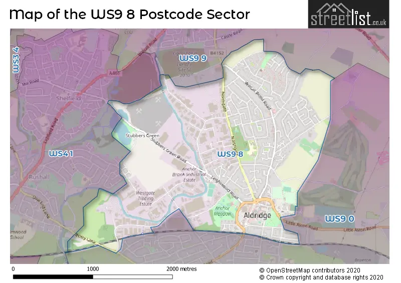
The WS9 8 Postcode shares a border with WS9 0 (WALSALL, Aldridge), WS4 1 (WALSALL, Rushall, Shelfield) and WS9 9 (WALSALL, Walsall Wood, Stonnall).
The sector is within the post town of WALSALL.
WS9 8 is a postcode sector within the WS9 postcode district which is within the WS Walsall postcode area.
The Royal Mail delivery office for the WS9 8 postal sector is the Aldridge Delivery Office.
The area of the WS9 8 postcode sector is 2.02 square miles which is 5.24 square kilometres or 1,295.03 square acres.
Waterways within the WS9 8 postcode sector include the Daw End Branch Canal, Daw End Branch, Aldridge Marina.

Map of the WS9 8 Postcode Sector
Explore the WS9 8 postcode sector by using our free interactive map.
| W | S | 9 | - | 8 | X | X |
| W | S | 9 | Space | 8 | Letter | Letter |
Official List of Streets
WALSALL (100 Streets)
Aldridge (38 Streets)
Unofficial Streets or Alternative Spellings
WALSALL
DUMBLEDERRY LANE WINDSOR WAYAldridge
WALSALL ROAD ALDRIDGE BY-PASS BAKERS LANE BOATMANS LANE BROAD MEADOW CEDAR COURT DALES LANE DAVIDS WAY HEADBROUGH WALK LOCKSIDE LONGLEAT ROAD NATURE TRAIL OLD RECTORY GARDENS PHOENIX DRIVE PORTLAND COURT SAINT THOMAS CLOSE SHERATON CLOSE STAMFORD WAY WALL CROFT WHARF APPROACHWalsall Wood
COPPICE LANEWeather Forecast for WS9 8
Press Button to Show Forecast for Aldridge
| Time Period | Icon | Description | Temperature | Rain Probability | Wind |
|---|---|---|---|---|---|
| 06:00 to 09:00 | Partly cloudy (day) | 3.0°C (feels like 0.0°C) | 1.00% | ENE 7 mph | |
| 09:00 to 12:00 | Cloudy | 6.0°C (feels like 4.0°C) | 5.00% | ENE 7 mph | |
| 12:00 to 15:00 | Overcast | 8.0°C (feels like 7.0°C) | 9.00% | ENE 4 mph | |
| 15:00 to 18:00 | Overcast | 9.0°C (feels like 8.0°C) | 11.00% | ENE 4 mph | |
| 18:00 to 21:00 | Cloudy | 8.0°C (feels like 7.0°C) | 9.00% | ENE 7 mph | |
| 21:00 to 00:00 | Partly cloudy (night) | 5.0°C (feels like 2.0°C) | 7.00% | E 7 mph |
Press Button to Show Forecast for Aldridge
| Time Period | Icon | Description | Temperature | Rain Probability | Wind |
|---|---|---|---|---|---|
| 00:00 to 03:00 | Partly cloudy (night) | 3.0°C (feels like 0.0°C) | 8.00% | ENE 7 mph | |
| 03:00 to 06:00 | Cloudy | 2.0°C (feels like 0.0°C) | 11.00% | ENE 7 mph | |
| 06:00 to 09:00 | Cloudy | 3.0°C (feels like 0.0°C) | 12.00% | ENE 9 mph | |
| 09:00 to 12:00 | Cloudy | 7.0°C (feels like 4.0°C) | 15.00% | ENE 9 mph | |
| 12:00 to 15:00 | Overcast | 9.0°C (feels like 6.0°C) | 23.00% | ENE 9 mph | |
| 15:00 to 18:00 | Overcast | 10.0°C (feels like 7.0°C) | 23.00% | ENE 11 mph | |
| 18:00 to 21:00 | Cloudy | 9.0°C (feels like 6.0°C) | 17.00% | ENE 11 mph | |
| 21:00 to 00:00 | Cloudy | 7.0°C (feels like 3.0°C) | 20.00% | NE 11 mph |
Press Button to Show Forecast for Aldridge
| Time Period | Icon | Description | Temperature | Rain Probability | Wind |
|---|---|---|---|---|---|
| 00:00 to 03:00 | Overcast | 6.0°C (feels like 2.0°C) | 24.00% | NE 11 mph | |
| 03:00 to 06:00 | Light rain | 6.0°C (feels like 2.0°C) | 52.00% | NE 13 mph | |
| 06:00 to 09:00 | Heavy rain | 6.0°C (feels like 2.0°C) | 77.00% | NNE 11 mph | |
| 09:00 to 12:00 | Heavy rain | 7.0°C (feels like 4.0°C) | 78.00% | N 11 mph | |
| 12:00 to 15:00 | Light rain | 8.0°C (feels like 5.0°C) | 53.00% | NNW 13 mph | |
| 15:00 to 18:00 | Light rain | 9.0°C (feels like 6.0°C) | 52.00% | NW 13 mph | |
| 18:00 to 21:00 | Light rain shower (day) | 9.0°C (feels like 6.0°C) | 38.00% | W 9 mph | |
| 21:00 to 00:00 | Clear night | 7.0°C (feels like 5.0°C) | 11.00% | SW 7 mph |
Schools and Places of Education Within the WS9 8 Postcode Sector
Cooper and Jordan Church of England Primary School
Voluntary aided school
The Green, Walsall, West Midlands, WS9 8NH
Head: Mr Paul Ingles
Ofsted Rating: Good
Inspection: 2019-02-13 (1899 days ago)
Website: Visit Cooper and Jordan Church of England Primary School Website
Phone: 01922743765
Number of Pupils: 476
Leighswood School
Community school
Broadmeadow, Walsall, West Midlands, WS9 8HZ
Head: Mr James Pearce
Ofsted Rating: Good
Inspection: 2019-07-04 (1758 days ago)
Website: Visit Leighswood School Website
Phone: 01922743621
Number of Pupils: 543
House Prices in the WS9 8 Postcode Sector
| Type of Property | 2018 Average | 2018 Sales | 2017 Average | 2017 Sales | 2016 Average | 2016 Sales | 2015 Average | 2015 Sales |
|---|---|---|---|---|---|---|---|---|
| Detached | £345,967 | 33 | £301,885 | 38 | £285,331 | 39 | £268,814 | 35 |
| Semi-Detached | £214,404 | 47 | £211,465 | 62 | £191,075 | 48 | £179,169 | 50 |
| Terraced | £191,329 | 36 | £166,714 | 37 | £181,676 | 42 | £158,572 | 36 |
| Flats | £150,712 | 64 | £154,850 | 81 | £106,019 | 35 | £108,666 | 34 |
Important Postcodes WS9 8 in the Postcode Sector
WS9 8AJ is the postcode for Anchor Meadow Health Centre, Anchor Meadow, and Anchor Meadow Health Centre, Anchor Meadow, Aldridge
WS9 8HZ is the postcode for Leighswood Primary School, Broadmeadow, KEY STAGE 2 BUILDING, Leighswood Primary School, Broadmeadow, and KEY STAGE 1 BUILDING, Leighswood Primary School, Broadmeadow
WS9 8NH is the postcode for Cooper & Jordan Primary School, The Green, and Cooper & Jordan Primary School, The Green, Aldridge
WS9 8NJ is the postcode for Youth & Community Association, Aldridge Manor House, Little Aston Road
WS9 8NP is the postcode for Walsall Metropolitan Borough Council, Aldridge Library, Rookery Lane
WS9 8SR is the postcode for Walsall Council, Brickyard Road Depot
| The WS9 8 Sector is within these Local Authorities |
|
|---|---|
| The WS9 8 Sector is within these Counties |
|
| The WS9 8 Sector is within these Water Company Areas |
|
Tourist Attractions within the WS9 8 Postcode Area
We found 1 visitor attractions within the WS9 postcode area
| ASTON MANOR ROAD TRANSPORT MUSEUM LTD |
|---|
| Museums & Art Galleries |
| Museum and / or Art Gallery |
| View ASTON MANOR ROAD TRANSPORT MUSEUM LTD on Google Maps |