The WV16 6 postcode sector stands on the Shropshire and Worcestershire border.
Did you know? According to the 2021 Census, the WV16 6 postcode sector is home to a bustling 7,778 residents!
Given that each sector allows for 400 unique postcode combinations. Letters C, I, K, M, O and V are not allowed in the last two letters of a postcode. With 241 postcodes already in use, this leaves 159 units available.
The largest settlement in the WV16 6 postal code is Highley followed by Ditton Priors, and Chelmarsh.
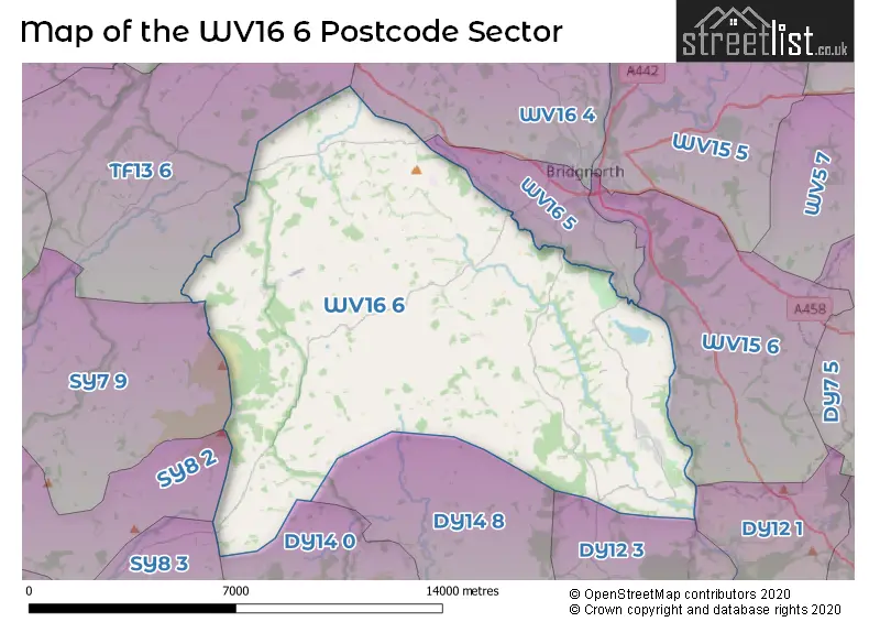
The WV16 6 Postcode shares a border with DY12 1 (BEWDLEY, Shatterford, Trimpley), DY14 0 (Hopton Wafers, Cleobury Mortimer, Oreton), DY14 8 (Cleobury Mortimer, Stottesdon, Oreton), TF13 6 (MUCH WENLOCK, Homer, Brockton), WV15 6 (Alveley, BRIDGNORTH, Quatford), WV16 4 (BRIDGNORTH, Astley Abbotts, Morville), WV16 5 (BRIDGNORTH, Eardington, Oldbury), DY12 3 (Kinlet, BEWDLEY, Arley), SY8 2 (LUDLOW, Bromfield, Rock Green), SY8 3 (Clee Hill, Knowbury, Bitterley) and SY7 9 (CRAVEN ARMS, Onibury, Diddlebury).
The sector is within the post town of BRIDGNORTH.
WV16 6 is a postcode sector within the WV1 postcode district which is within the WV Wolverhampton postcode area.
The Royal Mail delivery office for the WV16 6 postal sector is the unknown.
The area of the WV16 6 postcode sector is 59.50 square miles which is 154.12 square kilometres or 38,082.81 square acres.
Waterways within the WV16 6 postcode sector include the Borle Brook, River Severn.

Map of the WV16 6 Postcode Sector
Explore the WV16 6 postcode sector by using our free interactive map.
| W | V | 1 | 6 | - | 6 | X | X |
| W | V | 1 | 6 | Space | 6 | Letter | Letter |
Official List of Streets
Highley (60 Streets)
Chorley (6 Streets)
BRIDGNORTH (5 Streets)
Eardington (1 Streets)
Chelmarsh (7 Streets)
Monkhopton (3 Streets)
Upton Cressett (3 Streets)
Neenton (2 Streets)
Ditton Priors (14 Streets)
Billingsley (3 Streets)
Harpswood (1 Streets)
Chetton (1 Streets)
Unofficial Streets or Alternative Spellings
Weather Forecast for WV16 6
Press Button to Show Forecast for Wheathill Youth Hostel
| Time Period | Icon | Description | Temperature | Rain Probability | Wind |
|---|---|---|---|---|---|
| 09:00 to 12:00 | Heavy rain | 5.0°C (feels like 0.0°C) | 84.00% | NNW 13 mph | |
| 12:00 to 15:00 | Light rain | 7.0°C (feels like 4.0°C) | 55.00% | NW 11 mph | |
| 15:00 to 18:00 | Cloudy | 10.0°C (feels like 7.0°C) | 9.00% | WNW 11 mph | |
| 18:00 to 21:00 | Sunny day | 9.0°C (feels like 6.0°C) | 1.00% | W 11 mph | |
| 21:00 to 00:00 | Clear night | 5.0°C (feels like 2.0°C) | 0.00% | SW 9 mph |
Press Button to Show Forecast for Wheathill Youth Hostel
| Time Period | Icon | Description | Temperature | Rain Probability | Wind |
|---|---|---|---|---|---|
| 00:00 to 03:00 | Clear night | 4.0°C (feels like 1.0°C) | 0.00% | SW 9 mph | |
| 03:00 to 06:00 | Partly cloudy (night) | 5.0°C (feels like 1.0°C) | 3.00% | SSW 9 mph | |
| 06:00 to 09:00 | Cloudy | 6.0°C (feels like 2.0°C) | 5.00% | S 11 mph | |
| 09:00 to 12:00 | Cloudy | 9.0°C (feels like 6.0°C) | 11.00% | S 16 mph | |
| 12:00 to 15:00 | Cloudy | 12.0°C (feels like 8.0°C) | 11.00% | S 18 mph | |
| 15:00 to 18:00 | Cloudy | 12.0°C (feels like 9.0°C) | 13.00% | S 18 mph | |
| 18:00 to 21:00 | Partly cloudy (day) | 11.0°C (feels like 8.0°C) | 12.00% | S 16 mph | |
| 21:00 to 00:00 | Partly cloudy (night) | 9.0°C (feels like 6.0°C) | 10.00% | SSE 13 mph |
Press Button to Show Forecast for Wheathill Youth Hostel
| Time Period | Icon | Description | Temperature | Rain Probability | Wind |
|---|---|---|---|---|---|
| 00:00 to 03:00 | Clear night | 7.0°C (feels like 4.0°C) | 10.00% | SSE 11 mph | |
| 03:00 to 06:00 | Clear night | 7.0°C (feels like 3.0°C) | 9.00% | SE 11 mph | |
| 06:00 to 09:00 | Sunny day | 7.0°C (feels like 4.0°C) | 7.00% | SE 11 mph | |
| 09:00 to 12:00 | Sunny day | 11.0°C (feels like 8.0°C) | 6.00% | SE 13 mph | |
| 12:00 to 15:00 | Cloudy | 14.0°C (feels like 11.0°C) | 13.00% | SSE 16 mph | |
| 15:00 to 18:00 | Cloudy | 14.0°C (feels like 11.0°C) | 11.00% | SE 13 mph | |
| 18:00 to 21:00 | Light rain shower (day) | 13.0°C (feels like 11.0°C) | 32.00% | SE 9 mph | |
| 21:00 to 00:00 | Cloudy | 9.0°C (feels like 8.0°C) | 10.00% | SE 7 mph |
Press Button to Show Forecast for Wheathill Youth Hostel
| Time Period | Icon | Description | Temperature | Rain Probability | Wind |
|---|---|---|---|---|---|
| 00:00 to 03:00 | Cloudy | 8.0°C (feels like 6.0°C) | 10.00% | ESE 4 mph | |
| 03:00 to 06:00 | Cloudy | 7.0°C (feels like 6.0°C) | 10.00% | ENE 4 mph | |
| 06:00 to 09:00 | Cloudy | 9.0°C (feels like 8.0°C) | 14.00% | NE 4 mph | |
| 09:00 to 12:00 | Overcast | 12.0°C (feels like 11.0°C) | 17.00% | E 7 mph | |
| 12:00 to 15:00 | Cloudy | 14.0°C (feels like 13.0°C) | 17.00% | E 7 mph | |
| 15:00 to 18:00 | Cloudy | 15.0°C (feels like 14.0°C) | 17.00% | E 7 mph | |
| 18:00 to 21:00 | Cloudy | 14.0°C (feels like 13.0°C) | 13.00% | E 7 mph | |
| 21:00 to 00:00 | Cloudy | 11.0°C (feels like 10.0°C) | 19.00% | W 7 mph |
Schools and Places of Education Within the WV16 6 Postcode Sector
Brown Clee CofE Primary School
Voluntary controlled school
Station Road, Bridgnorth, Shropshire, WV16 6SS
Head: Mr Danny Harley
Ofsted Rating: Good
Inspection: 2019-01-10 (1935 days ago)
Website: Visit Brown Clee CofE Primary School Website
Phone: 01746712652
Number of Pupils: 118
Highley Community Primary School
Community school
Grasmere Drive, Bridgnorth, Shropshire, WV16 6EH
Head: Mr Tom Plim
Ofsted Rating: Good
Inspection: 2018-06-28 (2131 days ago)
Website: Visit Highley Community Primary School Website
Phone: 01746861541
Number of Pupils: 255
House Prices in the WV16 6 Postcode Sector
| Type of Property | 2018 Average | 2018 Sales | 2017 Average | 2017 Sales | 2016 Average | 2016 Sales | 2015 Average | 2015 Sales |
|---|---|---|---|---|---|---|---|---|
| Detached | £325,155 | 61 | £272,895 | 67 | £279,137 | 51 | £265,007 | 34 |
| Semi-Detached | £190,985 | 42 | £189,152 | 36 | £173,021 | 26 | £186,213 | 19 |
| Terraced | £135,750 | 14 | £129,777 | 24 | £116,315 | 33 | £191,643 | 14 |
| Flats | £0 | 0 | £66,000 | 1 | £0 | 0 | £95,000 | 1 |
Important Postcodes WV16 6 in the Postcode Sector
WV16 6EH is the postcode for Highley Primary School, Grasmere Drive, and Highley Primary School, Grasmere Drive, Highley
WV16 6JG is the postcode for The Severn Centre, Bridgnorth Road, Highley, and The Severn Centre, Bridgnorth Road
WV16 6SS is the postcode for Brown Clee C of E Primary School, Station Road
| The WV16 6 Sector is within these Local Authorities |
|
|---|---|
| The WV16 6 Sector is within these Counties |
|
| The WV16 6 Sector is within these Water Company Areas |
|
Tourist Attractions within the WV16 6 Postcode Area
We found 1 visitor attractions within the WV1 postcode area
| Rays Farm Country Matters |
|---|
| Farms |
| Farm / Rare Breeds / Farm Animals |
| View Rays Farm Country Matters on Google Maps |