The WV2 2 postcode sector is within the county of West Midlands.
Did you know? According to the 2021 Census, the WV2 2 postcode sector is home to a bustling 7,883 residents!
Given that each sector allows for 400 unique postcode combinations. Letters C, I, K, M, O and V are not allowed in the last two letters of a postcode. With 180 postcodes already in use, this leaves 220 units available.
The largest settlements in the WV2 2 postal code are WOLVERHAMPTON and Ettingshall.
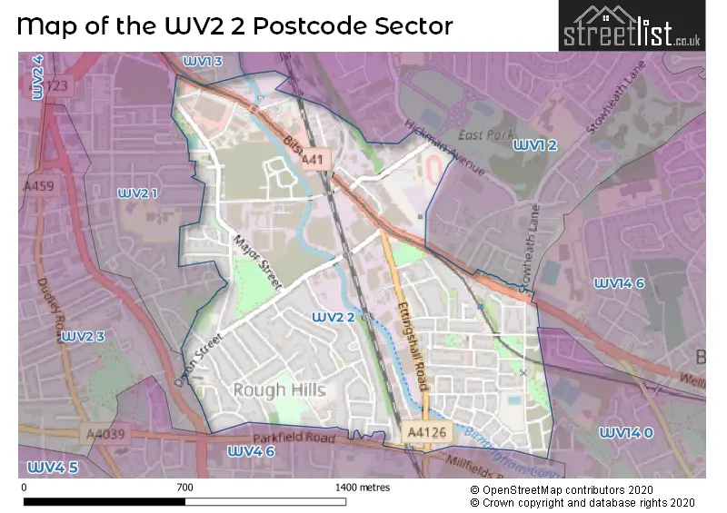
The WV2 2 Postcode shares a border with WV14 0 (BILSTON, Bradley), WV1 3 (WOLVERHAMPTON), WV2 1 (WOLVERHAMPTON), WV2 3 (WOLVERHAMPTON, Blakenhall), WV4 6 (WOLVERHAMPTON, Lanesfield, Ettingshall), WV14 6 (BILSTON) and WV1 2 (WOLVERHAMPTON, Stow Heath).
The sector is within the post town of WOLVERHAMPTON.
WV2 2 is a postcode sector within the WV2 postcode district which is within the WV Wolverhampton postcode area.
The Royal Mail delivery office for the WV2 2 postal sector is the Wolverhampton Delivery Office.
The area of the WV2 2 postcode sector is 0.72 square miles which is 1.86 square kilometres or 458.90 square acres.
Waterways within the WV2 2 postcode sector include the Birmingham Canal Navigations.

Map of the WV2 2 Postcode Sector
Explore the WV2 2 postcode sector by using our free interactive map.
| W | V | 2 | - | 2 | X | X |
| W | V | 2 | Space | 2 | Letter | Letter |
Official List of Streets
WOLVERHAMPTON (94 Streets)
Unofficial Streets or Alternative Spellings
BILSTON
HALL PARK STREET WELLINGTON ROADMoseley Village
STOWHEATH LANEWOLVERHAMPTON
ALL SAINTS ROAD CALEDONIA ROAD COMMERCIAL ROAD GORDON STREET HARGREAVES STREET HICKMAN AVENUE LIANA GARDENS MILLS ROAD PARKFIELD ROAD POND LANE PURBROOK ROADEttingshall
MANOR ROAD MILLFIELDS ROAD BRIDGE CLOSE CENTRAL TRADING ESTATE CHILLINGTON STREET COLTISHALL GREEN CULWICK STREET ETINGSHALLL ROAD WATERSIDE INDUSTRIAL ESTATEWeather Forecast for WV2 2
Press Button to Show Forecast for Monmore Green
| Time Period | Icon | Description | Temperature | Rain Probability | Wind |
|---|---|---|---|---|---|
| 03:00 to 06:00 | Overcast | 8.0°C (feels like 6.0°C) | 11.00% | SW 9 mph | |
| 06:00 to 09:00 | Overcast | 8.0°C (feels like 6.0°C) | 7.00% | SSW 9 mph | |
| 09:00 to 12:00 | Overcast | 11.0°C (feels like 9.0°C) | 10.00% | SSW 9 mph | |
| 12:00 to 15:00 | Overcast | 14.0°C (feels like 12.0°C) | 12.00% | SSW 9 mph | |
| 15:00 to 18:00 | Cloudy | 15.0°C (feels like 13.0°C) | 12.00% | SSW 9 mph | |
| 18:00 to 21:00 | Cloudy | 14.0°C (feels like 13.0°C) | 11.00% | SW 7 mph | |
| 21:00 to 00:00 | Cloudy | 12.0°C (feels like 11.0°C) | 10.00% | WSW 4 mph |
Press Button to Show Forecast for Monmore Green
| Time Period | Icon | Description | Temperature | Rain Probability | Wind |
|---|---|---|---|---|---|
| 00:00 to 03:00 | Cloudy | 10.0°C (feels like 9.0°C) | 10.00% | S 4 mph | |
| 03:00 to 06:00 | Cloudy | 8.0°C (feels like 7.0°C) | 13.00% | S 4 mph | |
| 06:00 to 09:00 | Cloudy | 9.0°C (feels like 8.0°C) | 9.00% | SSE 4 mph | |
| 09:00 to 12:00 | Cloudy | 12.0°C (feels like 11.0°C) | 10.00% | SSE 7 mph | |
| 12:00 to 15:00 | Partly cloudy (day) | 14.0°C (feels like 13.0°C) | 9.00% | SSE 7 mph | |
| 15:00 to 18:00 | Cloudy | 15.0°C (feels like 13.0°C) | 13.00% | SSE 9 mph | |
| 18:00 to 21:00 | Partly cloudy (day) | 14.0°C (feels like 12.0°C) | 12.00% | SW 7 mph | |
| 21:00 to 00:00 | Cloudy | 11.0°C (feels like 10.0°C) | 13.00% | WSW 7 mph |
House Prices in the WV2 2 Postcode Sector
| Type of Property | 2018 Average | 2018 Sales | 2017 Average | 2017 Sales | 2016 Average | 2016 Sales | 2015 Average | 2015 Sales |
|---|---|---|---|---|---|---|---|---|
| Detached | £194,730 | 33 | £193,222 | 35 | £196,574 | 31 | £185,275 | 26 |
| Semi-Detached | £141,994 | 69 | £132,264 | 61 | £124,017 | 57 | £121,494 | 57 |
| Terraced | £115,674 | 40 | £118,369 | 57 | £121,245 | 52 | £106,738 | 33 |
| Flats | £82,929 | 7 | £71,333 | 3 | £75,460 | 25 | £0 | 0 |
| The WV2 2 Sector is within these Local Authorities |
|
|---|---|
| The WV2 2 Sector is within these Counties |
|
| The WV2 2 Sector is within these Water Company Areas |
|