The B10 9 postcode sector is within the county of West Midlands.
Did you know? According to the 2021 Census, the B10 9 postcode sector is home to a bustling 19,015 residents!
Given that each sector allows for 400 unique postcode combinations. Letters C, I, K, M, O and V are not allowed in the last two letters of a postcode. With 169 postcodes already in use, this leaves 231 units available.
The largest settlements in the B10 9 postal code are BIRMINGHAM and Small Heath.
The B10 9 Postcode shares a border with B9 5 (BIRMINGHAM, Small Heath, Bordesley Green), B10 0 (BIRMINGHAM, Small Heath) and B25 8 (BIRMINGHAM, Yardley).
The sector is within the post town of BIRMINGHAM.
B10 9 is a postcode sector within the B1 postcode district which is within the B Birmingham postcode area.
The Royal Mail delivery office for the B10 9 postal sector is the unknown.
The area of the B10 9 postcode sector is 0.66 square miles which is 1.72 square kilometres or 424.71 square acres.
Waterways within the B10 9 postcode sector include the River Cole.

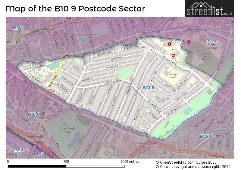
Map of the B10 9 Postcode Sector
Explore the B10 9 postcode sector by using our free interactive map.
| B | 1 | 0 | - | 9 | X | X |
| B | 1 | 0 | Space | 9 | Letter | Letter |
Official List of Streets
Small Heath (7 Streets)
BIRMINGHAM (33 Streets)
Unofficial Streets or Alternative Spellings
BIRMINGHAM
EVERSLEY ROAD NEWBRIDGE ROAD NEWLAND ROAD COLE VALLEY ROUTE DEVONSHIRE VILLAS HUGH VILLAS WOODBINE AVENUESmall Heath
GREEN LANESchools and Places of Education Within the B10 9 Postcode Sector
Marlborough Primary School
Academy converter
Marlborough Road, Birmingham, West Midlands, B10 9NY
Head: Mrs Razia Ali
Ofsted Rating: Good
Inspection: 2023-05-17 (372 days ago)
Website: Visit Marlborough Primary School Website
Phone: 01214647933
Number of Pupils: 638
Small Heath Leadership Academy
Academy sponsor led
Muntz Street, Birmingham, West Midlands, B10 9RX
Head: Mrs Enass Al-Ani
Ofsted Rating: Good
Inspection: 2022-05-12 (742 days ago)
Website: Visit Small Heath Leadership Academy Website
Phone: 01214647997
Number of Pupils: 1153
Somerville Primary (NC) School
Community school
Somerville Road, Birmingham, West Midlands, B10 9EN
Head: Mr Izhar Khan
Ofsted Rating: Good
Inspection: 2022-03-02 (813 days ago)
Website: Visit Somerville Primary (NC) School Website
Phone: 01216750956
Number of Pupils: 730
St Benedict's Primary School
Community school
St Benedict's Road, Birmingham, West Midlands, B10 9DP
Head: Mrs Emma Nott
Ofsted Rating: Good
Inspection: 2023-01-12 (497 days ago)
Website: Visit St Benedict's Primary School Website
Phone: 01214646420
Number of Pupils: 374
Starbank School
Academy sponsor led
Hob Moor Road, Birmingham, , B10 9BT
Head: Mr Gaetano Ferrante
Ofsted Rating: Good
Inspection: 2023-06-07 (351 days ago)
Website: Visit Starbank School Website
Phone: 01214642638
Number of Pupils: 2186
House Prices in the B10 9 Postcode Sector
| Type of Property | 2018 Average | 2018 Sales | 2017 Average | 2017 Sales | 2016 Average | 2016 Sales | 2015 Average | 2015 Sales |
|---|---|---|---|---|---|---|---|---|
| Detached | £0 | 0 | £0 | 0 | £0 | 0 | £0 | 0 |
| Semi-Detached | £137,265 | 17 | £134,333 | 12 | £135,006 | 16 | £113,429 | 7 |
| Terraced | £140,817 | 70 | £131,349 | 53 | £122,027 | 76 | £114,148 | 59 |
| Flats | £0 | 0 | £47,500 | 1 | £59,000 | 1 | £55,000 | 2 |
Important Postcodes B10 9 in the Postcode Sector
B10 9AB is the postcode for Charles Road Surgery, 192 Charles Road
B10 9BT is the postcode for Starbank School, Hob Moor Road, Waverley School, Hob Moor Road, Sports Block, Starbank School, Hob Moor Road, Phoenix Building, Starbank School, Hob Moor Road, and Main Building, Starbank School, Hob Moor Road
B10 9DP is the postcode for NURSERY BLOCK, Birmingham City Council, St. Benedicts Infant School, MAIN BLOCK, Birmingham City Council, St. Benedicts Infant School, MAIN BLOCK, St Benedict's Primary School, St Benedict's Road, and Birmingham City Council, St. Benedicts Infant School
B10 9EN is the postcode for SOMERVILLE JUNIOR AND INFANTS SCHOOL, SOMERVILLE ROAD, BORDESLEY GREEN, and Sommerville Primary School, Somerville Road
B10 9HH is the postcode for Eden Girls Leadership Academy Birmingham, 256 Hob Moor Road, Bordesley Green
B10 9JH is the postcode for Little Bromwich Centre, 150 Hobmoor Road, North Birmingham Health Authority, Newbridge House, 130 Hob Moor Road, NEWBRIDGE HOUSE, 130 HOB MOOR ROAD, BORDESLEY GREEN, Newbridge House, 130 Hob Moor Road, Heart Of Birmingham Teaching PCT, Riverside Lodge, 192 Hob Moor Road, Small Heath, Riverside Lodge Intermediate Care Centre, 160 Hob Moor Road, Small Heath, Riverside Lodge Intermediate Care Centre, 160 Hob Moor Road, and LITTLE BROMWICH CENTRE, HOB MOOR ROAD, BORDESLEY GREEN
B10 9LR is the postcode for Main Building, Starbank Junior & Infant School, Starbank Road, Starbank Junior & Infant School, Starbank Road, Junior Building, Starbank Junior & Infant School, Starbank Road, and Pinder Building, Starbank Junior and Infant School, Starbank Road
B10 9NY is the postcode for Marlborough Primary School, Marlborough Road, MARLBOROUGH PRIMARY SCHOOL, MARLBOROUGH ROAD, BIRMINGHAM, and Marlborough Junior & Infant School, Marlborough Road
B10 9QP is the postcode for Bertram Childrens Centre, 6 Bertram Road
B10 9RX is the postcode for Small Heath Library, Muntz Street, Small Heath Youth & Community Centre, Muntz Street, and BIRMINGHAM CITY COUNCIL, Small Heath Leisure Centre, Muntz Street
| The B10 9 Sector is within these Local Authorities |
|
|---|---|
| The B10 9 Sector is within these Counties |
|
| The B10 9 Sector is within these Water Company Areas |
|