The B14 6 postcode sector is within the county of West Midlands.
Did you know? According to the 2021 Census, the B14 6 postcode sector is home to a bustling 11,668 residents!
Given that each sector allows for 400 unique postcode combinations. Letters C, I, K, M, O and V are not allowed in the last two letters of a postcode. With 184 postcodes already in use, this leaves 216 units available.
The largest settlements in the B14 6 postal code are BIRMINGHAM and Kings Heath.
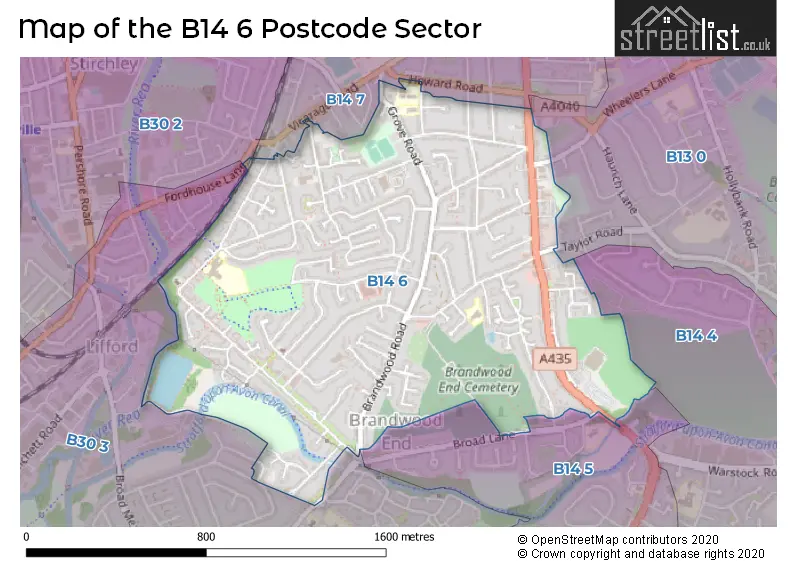
The B14 6 Postcode shares a border with B13 0 (BIRMINGHAM, Moseley), B14 4 (BIRMINGHAM, Yardley Wood, Kings Heath), B14 5 (BIRMINGHAM), B14 7 (Kings Heath, BIRMINGHAM), B30 2 (BIRMINGHAM, Stirchley, Bournville) and B30 3 (BIRMINGHAM, Kings Norton, Stirchley).
The sector is within the post town of BIRMINGHAM.
B14 6 is a postcode sector within the B1 postcode district which is within the B Birmingham postcode area.
The Royal Mail delivery office for the B14 6 postal sector is the unknown.
The area of the B14 6 postcode sector is 0.96 square miles which is 2.49 square kilometres or 615.34 square acres.
Waterways within the B14 6 postcode sector include the Stratford-upon-Avon Canal, Brandwood Tunnel, River Rea.

Map of the B14 6 Postcode Sector
Explore the B14 6 postcode sector by using our free interactive map.
| B | 1 | 4 | - | 6 | X | X |
| B | 1 | 4 | Space | 6 | Letter | Letter |
Official List of Streets
BIRMINGHAM (89 Streets)
Kings Heath (10 Streets)
Unofficial Streets or Alternative Spellings
Schools and Places of Education Within the B14 6 Postcode Sector
Allens Croft Nursery School
Local authority nursery school
Allens Croft Road, Birmingham, West Midlands, B14 6RP
Head: Mr David Aldworth
Ofsted Rating: Requires improvement
Inspection: 2022-06-09 (714 days ago)
Website: Visit Allens Croft Nursery School Website
Phone: 01216750362
Number of Pupils: 162
Allens Croft Primary School
Community school
Allens Croft Road, Birmingham, West Midlands, B14 6RP
Head: Paula Weaver
Ofsted Rating: Good
Inspection: 2019-01-11 (1959 days ago)
Website: Visit Allens Croft Primary School Website
Phone: 01216752611
Number of Pupils: 417
Colmore Infant and Nursery School
Community school
Colmore Road, Birmingham, West Midlands, B14 6AJ
Head: Mrs Tracy Lakey
Ofsted Rating: Outstanding
Inspection: 2023-11-08 (197 days ago)
Website: Visit Colmore Infant and Nursery School Website
Phone: 01214642820
Number of Pupils: 412
Colmore Junior School
Community school
Colmore Road, Birmingham, West Midlands, B14 6AJ
Head: Mr Jon Gale
Ofsted Rating: Good
Inspection: 2023-03-29 (421 days ago)
Website: Visit Colmore Junior School Website
Phone: 01214642843
Number of Pupils: 477
Woodthorpe Junior and Infant School
Community school
Greenwood Close, Birmingham, West Midlands, B14 6ET
Head: Ms Linda Jane McGrath
Ofsted Rating: Good
Inspection: 2023-11-22 (183 days ago)
Website: Visit Woodthorpe Junior and Infant School Website
Phone: 01214645203
Number of Pupils: 213
House Prices in the B14 6 Postcode Sector
| Type of Property | 2018 Average | 2018 Sales | 2017 Average | 2017 Sales | 2016 Average | 2016 Sales | 2015 Average | 2015 Sales |
|---|---|---|---|---|---|---|---|---|
| Detached | £390,814 | 14 | £340,656 | 18 | £293,000 | 17 | £278,456 | 24 |
| Semi-Detached | £238,407 | 72 | £237,083 | 53 | £206,739 | 80 | £210,363 | 55 |
| Terraced | £199,566 | 41 | £185,143 | 55 | £182,171 | 40 | £166,902 | 40 |
| Flats | £103,670 | 28 | £106,257 | 29 | £86,519 | 21 | £83,803 | 18 |
Important Postcodes B14 6 in the Postcode Sector
B14 6AA is the postcode for Kingsfield Medical Centre, 146 Alcester Road South
B14 6AJ is the postcode for JUNIOR SCHOOL, Colmore Junior & Infant School, Colmore Road, Colmore Junior & Infant School, Colmore Road, and INFANT SCHOOL, Colmore Junior & Infant School, Colmore Road
B14 6ER is the postcode for Cocks Moors Woods Leisure Centre, Alcester Road South, and BIRMINGHAM CITY COUNCIL, Cocks Moors Woods Leisure Centre, Alcester Road South
B14 6ET is the postcode for WOODTHORPE PRIMARY SCHOOL, GREENWOOD CLOSE, BIRMINGHAM, and Woodthorpe Primary School, Greenwood Close
B14 6RP is the postcode for Allens Croft Childrens Centre, Allens Croft Road, Allens Croft Primary School, KS2 Building, Allens Croft Road, ALLENS CROFT PRIMARY SCHOOL, ALLENS CROFT ROAD, BIRMINGHAM, Allens Croft Nursery School, Allens Croft Road, Allens Croft Primary School, Allens Croft Road, and Allens Croft Primary School, KS1 Building, Allens Croft Road
| The B14 6 Sector is within these Local Authorities |
|
|---|---|
| The B14 6 Sector is within these Counties |
|
| The B14 6 Sector is within these Water Company Areas |
|