Postcode sector

The B14 5 Birmingham (Warstock) Postcode Sector

A wide range of spatial data has been analysed to present this overview of the B14 5 postcode sector. If you would like anything added, please contact us.

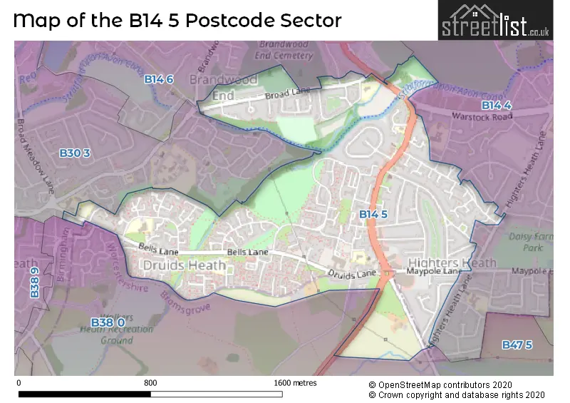
The B14 5 postcode sector stands on the West Midlands and Worcestershire border.

According to the 2021 Census, the B14 5 postcode sector is home to 10,658 residents.

Each postcode sector can contain up to 400 unique postcode units. With 222 already in use, that leaves 178 potentially available.

The B14 5 postal code covers the settlement of BIRMINGHAM.

The B14 5 Postcode shares a border with B14 4 (BIRMINGHAM, Yardley Wood, Kings Heath), B47 5 (Hollywood), B14 6 (BIRMINGHAM, Kings Heath), B30 3 (BIRMINGHAM, Kings Norton, Stirchley) and B38 0 (BIRMINGHAM, Kings Norton).

Streets indexed 135
Post towns 1
Schools 3
Postcode units used 222

Map of B14 5

Explore the postcode sector using the interactive map.

Larger circles indicate higher recorded crime totals.

On this page

Key facts

  • Within the post town of BIRMINGHAM.
  • B14 5 is in the B14 district, within the B Birmingham area.
  • Royal Mail delivery office: Moseley Delivery Office.
  • Area: 0.89 sq mi (2.31 km² / 570.00 acres).
  • Waterways include Stratford-upon-Avon Canal.

Street list for B14 5

ALCESTER ROAD SOUTH

A-road

BILLESLEY, Birmingham, West Midlands

A Road
USRN: 2700316

ALCESTER ROAD SOUTH

A-road

BILLESLEY, Birmingham, Worcestershire

A Road
USRN: 2700316

ALCESTER ROAD SOUTH

Minor road

Hollywood, Worcestershire

Minor Road
USRN: 4700011

ALDBURY ROAD

Birmingham, West Midlands

Local Road
USRN: 2700318

ALLWELL DRIVE

Birmingham, West Midlands

Local Road
USRN: 2700319

AMWELL GROVE

Birmingham, West Midlands

Local Road
USRN: 2700320

ARUNDEL ROAD

Birmingham, West Midlands

Local Road
USRN: 2700325

ARUNDEL ROAD

Birmingham, Worcestershire

Local Road
USRN: 2700325

ASHWATER DRIVE

Birmingham, West Midlands

Local Road
USRN: 2700328

BADON COVERT

Birmingham, West Midlands

Local Road
USRN: 2708435

BARNPARK COVERT

Birmingham, West Midlands

Local Road
USRN: 2700331

BAVERSTOCK ROAD

Birmingham, West Midlands

Local Road
USRN: 2700333

BAYSTON ROAD

Birmingham, West Midlands

Local Road
USRN: 2700334

BECKFIELD CLOSE

Birmingham, West Midlands

Local Road
USRN: 2700335

BELL MEADOW WAY

Birmingham, West Midlands


USRN: 2708480

BELLS FARM CLOSE

Birmingham, West Midlands

Local Road
USRN: 2700336

BELLS LANE

Minor road

Birmingham, West Midlands

Minor Road
USRN: 2700337

BICKNELL CROFT

Birmingham, West Midlands

Local Road
USRN: 2700341

BRAMSHAW CLOSE

Birmingham, West Midlands

Local Road
USRN: 2700344

BRITFORD CLOSE

Birmingham, West Midlands

Local Road
USRN: 2700347

BROAD LANE

Minor road

Birmingham, West Midlands

Minor Road
USRN: 2700348

BROCKWORTH ROAD

Birmingham, West Midlands

Local Road
USRN: 2700351

BROOM DRIVE

Birmingham, West Midlands

Local Road
USRN: 2700353

BRYNSIDE CLOSE

Birmingham, West Midlands

Local Road
USRN: 2700355

BULFORD CLOSE

Birmingham, West Midlands

Local Road
USRN: 2700356

CAMFORD GROVE

Birmingham, West Midlands

Local Road
USRN: 2700357

CHANSTON AVENUE

Birmingham, West Midlands

Local Road
USRN: 2700359

CHERHILL COVERT

Birmingham, West Midlands

Local Road
USRN: 2700363

CHISELDON CROFT

Birmingham, West Midlands

Local Road
USRN: 2700366

CLANDON CLOSE

Birmingham, West Midlands

Local Road
USRN: 2700367

COLESBOURNE AVENUE

Birmingham, West Midlands

Local Road
USRN: 2700371

COTFORD ROAD

Birmingham, West Midlands

Local Road
USRN: 2700374

DAUNTSEY COVERT

Birmingham, West Midlands

Local Road
USRN: 2700385

DENHOLME GROVE

Birmingham, West Midlands

Local Road
USRN: 2700387

DENVER ROAD

Birmingham, West Midlands

Local Road
USRN: 2700388

DIAL CLOSE

Birmingham, West Midlands

Local Road
USRN: 2700389

DORSTONE COVERT

Birmingham, West Midlands

Local Road
USRN: 2700392

DREWS MEADOW CLOSE

Birmingham, West Midlands

Local Road
USRN: 2700395

DRUIDS LANE

Birmingham, West Midlands

Local Road
USRN: 2700396

DRUIDS LANE

Birmingham, Worcestershire

Local Road
USRN: 2700396

DURNFORD CROFT

Birmingham, West Midlands

Local Road
USRN: 2700399

DURNFORD CROFT

Birmingham, Worcestershire

Local Road
USRN: 2700399

EAGLE CROFT

Birmingham, West Midlands

Local Road
USRN: 2700400

EASMORE CLOSE

Birmingham, West Midlands

Local Road
USRN: 2700401

EASTERTON CROFT

Birmingham, West Midlands

Local Road
USRN: 2700402

EBMORE DRIVE

Birmingham, West Midlands

Local Road
USRN: 2700403

EDWARD ROAD

BILLESLEY, Birmingham, West Midlands

Local Road
USRN: 2700406

ELKSTONE COVERT

Birmingham, West Midlands

Local Road
USRN: 2700408

FIRHILL CROFT

Birmingham, West Midlands

Local Road
USRN: 2700413

FORDER GROVE

Birmingham, West Midlands

Local Road
USRN: 2700415

GARRATTS WALK

Birmingham, West Midlands


USRN: 2708726

GLENAVON ROAD

Birmingham, West Midlands

Local Road
USRN: 2700420

GOMELDON AVENUE

Birmingham, West Midlands

Local Road
USRN: 2700421

GOODRICH COVERT

Birmingham, West Midlands

Local Road
USRN: 2700423

GRENDON ROAD

Birmingham, West Midlands

Local Road
USRN: 2700431

GULLSWOOD CLOSE

Birmingham, West Midlands

Local Road
USRN: 2700432

HARDWICKE WALK

Birmingham, West Midlands


USRN: 2708772

HAWKHURST ROAD

Birmingham, West Midlands

Local Road
USRN: 2700435

HENLOW ROAD

Birmingham, West Midlands

Local Road
USRN: 2700441

HIGHTERS HEATH LANE

Minor road

Birmingham, West Midlands

Minor Road
USRN: 2700446

HIGHTERS HEATH LANE

Minor road

Birmingham, Worcestershire

Minor Road
USRN: 2700446

HIGHTERS ROAD

Birmingham, West Midlands

Local Road
USRN: 2700447

HOLLYWOOD BYPASS A435

A-road

Hollywood, Worcestershire

A Road
USRN: 4700557

IDMISTON CROFT

Birmingham, West Midlands

Local Road
USRN: 2700457

IRIS DRIVE

Birmingham, West Midlands

Local Road
USRN: 2708842

JASMIN CROFT

Birmingham, West Midlands

Local Road
USRN: 2700460

KEMSLEY ROAD

Birmingham, West Midlands

Local Road
USRN: 2700462

KIMPTON CLOSE

Birmingham, West Midlands

Local Road
USRN: 2700466

KINGHAM COVERT

Birmingham, West Midlands

Local Road
USRN: 2700467

KINSEY GROVE

Birmingham, West Midlands

Local Road
USRN: 2700469

LAKEDOWN CLOSE

Birmingham, West Midlands

Local Road
USRN: 2700470

LAKEDOWN CLOSE

Birmingham, Worcestershire

Local Road
USRN: 2700470

LARK CLOSE

Birmingham, West Midlands

Local Road
USRN: 2708892

LARKHILL WALK

Birmingham, West Midlands


USRN: 2708893

LAVENDER CLOSE

Birmingham, West Midlands


USRN: 2752033

LIMEKILN LANE

Birmingham, West Midlands

Local Road
USRN: 2700479

LINPOLE WALK

Birmingham, West Midlands


USRN: 2708910

LITTLECOTE CROFT

Birmingham, West Midlands

Local Road
USRN: 2700484

LOUISE CROFT

Birmingham, West Midlands

Local Road
USRN: 2700486

MANNINGFORD ROAD

Birmingham, West Midlands

Local Road
USRN: 2700489

MARSHAM ROAD

Birmingham, West Midlands

Local Road
USRN: 2700492

MAYPOLE CLOSE

Birmingham, West Midlands

Local Road
USRN: 2751910

MAYPOLE LANE

Minor road

Birmingham, West Midlands

Minor Road
USRN: 2700496

MAYPOLE LANE

Minor road

Birmingham, Worcestershire

Minor Road
USRN: 2700496

MEADFOOT AVENUE

Birmingham, West Midlands

Local Road
USRN: 2700498

MEADOW WALK

Birmingham, West Midlands


USRN: 2708959

MIDVALE DRIVE

Birmingham, West Midlands

Local Road
USRN: 2700504

MILLPOOL GARDENS

Birmingham, West Midlands

Local Road
USRN: 2700505

MILSTON CLOSE

Birmingham, West Midlands

Local Road
USRN: 2700507

MILSTON CLOSE

Birmingham, Worcestershire

Local Road
USRN: 2700507

MITCHELDEAN COVERT

Birmingham, West Midlands

Local Road
USRN: 2700508

MOUNTFIELD CLOSE

Birmingham, West Midlands

Local Road
USRN: 2700515

MYRTLE AVENUE

BILLESLEY, Birmingham, West Midlands

Local Road
USRN: 2700516

NAFFORD GROVE

Birmingham, West Midlands

Local Road
USRN: 2700517

NETHERAVON CLOSE

Birmingham, West Midlands

Local Road
USRN: 2700518

NORLAN DRIVE

Birmingham, West Midlands

Local Road
USRN: 2700521

NORTHLEACH AVENUE

Birmingham, West Midlands

Local Road
USRN: 2700522

NUTHURST GROVE

Birmingham, West Midlands

Local Road
USRN: 2700523

OATLANDS WALK

Birmingham, West Midlands


USRN: 2709024

OGBURY CLOSE

Birmingham, West Midlands

Local Road
USRN: 2700525

OGBURY CLOSE

Birmingham, Worcestershire

Local Road
USRN: 2700525

ORCHESTON WALK

Birmingham, West Midlands


USRN: 2709042

PEG LEG WALK

Birmingham, West Midlands


USRN: 2709073

PENNYACRE ROAD

Birmingham, West Midlands

Local Road
USRN: 2700534

PETTITT CLOSE

Birmingham, West Midlands

Local Road
USRN: 2700538

POSTON CROFT

Birmingham, West Midlands

Local Road
USRN: 2700542

POUND ROAD

Birmingham, West Midlands

Local Road
USRN: 2700543

REDBURN DRIVE

Birmingham, West Midlands

Local Road
USRN: 2700553

ROWCROFT COVERT

Birmingham, West Midlands

Local Road
USRN: 2700561

SAXELBY CLOSE

Birmingham, West Midlands

Local Road
USRN: 2700565

SAXONS WAY

Birmingham, West Midlands

Local Road
USRN: 2700567

SHREWTON AVENUE

Birmingham, West Midlands

Local Road
USRN: 2700579

SLADEPOOL FARM ROAD

Birmingham, West Midlands

Local Road
USRN: 2700581

SOUTHWOOD COVERT

Birmingham, West Midlands

Local Road
USRN: 2700583

ST JUDES CLOSE

Birmingham, West Midlands

Local Road
USRN: 2700585

STAPLEFORD CROFT

Birmingham, West Midlands

Local Road
USRN: 2700587

STONEHENGE CROFT

Birmingham, West Midlands

Local Road
USRN: 2700588

STOT FOLD ROAD

Birmingham, West Midlands

Local Road
USRN: 2700590

TANDY DRIVE

Birmingham, West Midlands

Local Road
USRN: 2700592

THORNHAM WAY

Birmingham, West Midlands

Local Road
USRN: 2700599

THRUXTON CLOSE

Birmingham, West Midlands

Local Road
USRN: 2700600

TIDWORTH CROFT

Birmingham, West Midlands

Local Road
USRN: 2700601

TILSHEAD CLOSE

Birmingham, West Midlands

Local Road
USRN: 2700602

TOP FIELD WALK

Birmingham, West Midlands


USRN: 2709334

WHITLAND DRIVE

Birmingham, West Midlands

Local Road
USRN: 2700621

WILLSBRIDGE COVERT

Birmingham, West Midlands

Local Road
USRN: 2700626

WILSFORD CLOSE

Birmingham, West Midlands

Local Road
USRN: 2700628

WILSFORD CLOSE

Birmingham, Worcestershire

Local Road
USRN: 2700628

WINTERBOURNE CROFT

Birmingham, West Midlands

Local Road
USRN: 2700630

WITHINGTON COVERT

Birmingham, West Midlands

Local Road
USRN: 2700631

WOODMAN ROAD

Birmingham, West Midlands

Local Road
USRN: 2700632

WYNDS COVERT

Birmingham, West Midlands

Local Road
USRN: 2700636

WYNSTEAD COVERT

Birmingham, West Midlands

Local Road
USRN: 2700637

YARNBURY CLOSE

Birmingham, West Midlands

Local Road
USRN: 2700639

YARNBURY CLOSE

Birmingham, Worcestershire

Local Road
USRN: 2700639

Crime overview

Top streets by recorded crime

Most common crime types

Crime type Count
Violence and sexual offences 1445
Shoplifting 499
Other theft 348
Criminal damage and arson 298
Vehicle crime 247
Public order 172
Burglary 167
Robbery 87
Other crime 68
Possession of weapons 65
Drugs 54
Theft from the person 33
Bicycle theft 2

Postcodes in this sector

Schools and places of education

Bells Farm Primary School

Community school

Bells Farm Close, Birmingham, West Midlands, B14 5QP

Head: Miss Tammy Williams

Ofsted: Outstanding

Inspection: 2011-10-12

Pupils: 199

St Alban's Catholic Primary School

Voluntary aided school

Broad Lane, Birmingham, West Midlands, B14 5AL

Head: Mrs Rebecca McKinney

Ofsted: Good

Inspection: 2018-09-13

Pupils: 211

St Jude's Catholic Primary School

Voluntary aided school

St Jude's Close, Birmingham, West Midlands, B14 5PD

Head: Mrs Bernadette Smith

Ofsted: Good

Inspection: 2022-11-03

Pupils: 205

Neighbouring sectors and settlements

Neighbouring postcode sectors

Settlements within the sector

House prices

Yearly house price averages for the B14 5 postcode sector
Type of property 2025 average 2025 sales 2024 average 2024 sales 2023 average 2023 sales 2022 average 2022 sales
Detached £333,444 2 £304,600 5 £322,600 4 £286,182 11
Semi-detached £258,182 44 £227,139 40 £217,194 31 £225,992 59
Terraced £212,241 45 £190,119 54 £187,994 55 £186,870 55
Flats £135,667 6 £126,167 6 £139,333 6 £120,112 12

Important postcodes and buildings

B14 5AL

B14 5AL is the postcode for St. Albans Catholic Primary School, Broad Lane, St Alban's Catholic Primary School, Broad Lane, and St. Albans RC Junior & Infant School, Broad Lane

B14 5DJ

B14 5DJ is the postcode for Maypole Health Centre, 10 Sladepool Farm Road

B14 5EU

B14 5EU is the postcode for Millpool Gardens Community Day Nursery, 2 Millpool Gardens

B14 5LD

B14 5LD is the postcode for 6, Manningford Road

B14 5NJ

B14 5NJ is the postcode for MAYPOLE YOUTH CENTRE, IDMISTON CROFT, and Birmingham City Council, Druids Heath Library, 1 Idmiston Croft

B14 5PD

B14 5PD is the postcode for St. Judes Catholic Primary School, Baverstock Road

B14 5QP

B14 5QP is the postcode for Birmingham City Council, Bells Farm Primary School, and BELLS FARM PRIMARY SCHOOL AND CHILDRENS CENTRE, BELLS FARM CLOSE

B14 5RY

B14 5RY is the postcode for THE OAKS PRIMARY SCHOOL, BELLS LANE, BIRMINGHAM, The Oaks Primary School, Bells Lane, and The Oaks School, 336 Bells Lane

B14 5TL

B14 5TL is the postcode for Baverstock Foundation School, 501 Bells Lane

B14 5YG

B14 5YG is the postcode for Bells Farm Primary School, Bells Farm Close, and Bells Farm Junior & Infant School, Brockworth Road

Administrative coverage

The B14 5 sector is within these local authorities
  • Birmingham District (B)
  • Bromsgrove District
The B14 5 sector is within these counties
  • West Midlands
  • Worcestershire
The B14 5 sector is within these water company areas
  • Severn Trent

Maps and visuals

A word cloud for the B14 5 postcode sector
A word cloud showing place names for the B14 5 postcode sector.
Map of the B14 5 postcode sector and surrounding area
Map of the postcode sector and surrounding area.
Postcode format for B14 5
B 1 4 - 5 X X
B 1 4 Space 5 Letter Letter

Weather forecast for B14 5

Weather Forecast for Highter's Heath

Powered by Met Office DataPoint under the Open Government Licence.

© streetlist.co.uk 2026
Contains public sector information licensed under the Open Government Licence v2.0.
© Crown copyright and database rights 2026
© OpenStreetMap contributors 2026