The B14 postcode district is a postal district located in the B Birmingham postcode area with a population of 43,289 residents according to the 2021 England and Wales Census.
The area of the B14 postcode district is 3.53 square miles which is 9.13 square kilometres or 2,257.06 acres.
Currently, the B14 district has about 777 postcode units spread across 4 geographic postcode sectors.
Given that each sector allows for 400 unique postcode combinations, the district has a capacity of 1,600 postcodes. With 777 postcodes already in use, this leaves 823 units available.
The largest settlement in the B14 postal code is BIRMINGHAM followed by Kings Heath, and Yardley Wood.
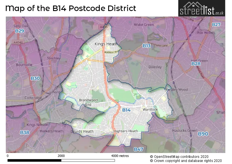
The B14 Postcode shares a border with B28 (BIRMINGHAM, Hall Green), B13 (BIRMINGHAM, Moseley), B30 (BIRMINGHAM, Kings Norton, Stirchley), B90 (Shirley, Cheswick Green, Tidbury Green), B38 (BIRMINGHAM, Kings Norton) and B47 (Hollywood, Wythall).
The primary settlement in the B14 postcode district is Birmingham, located in the West Midlands. Kings Heath and Maypole are also significant settlements within the district. The post town associated with the B14 postcode district is Birmingham in the West Midlands.
For the district B14, we have data on 4 postcode sectors. Here's a breakdown: The sector B14 4, covers Birmingham in West Midlands. The sector B14 5, covers Birmingham in West Midlands. The sector B14 6, covers Birmingham and Kings Heath in West Midlands. The sector B14 7, covers Kings Heath and Birmingham in West Midlands.

Map of the B14 Postcode District
Explore the B14 postcode district by using our free interactive map.
When it comes to local government, postal geography often disregards political borders. However, for a breakdown in the B14 District: the district mostly encompasses the Birmingham District (B) (767 postcodes), and finally, the Bromsgrove District area (4 postcodes).
Weather Forecast for B14
Press Button to Show Forecast for King's Heath
| Time Period | Icon | Description | Temperature | Rain Probability | Wind |
|---|---|---|---|---|---|
| 12:00 to 15:00 | Overcast | 7.0°C (feels like 4.0°C) | 53.00% | ENE 11 mph | |
| 15:00 to 18:00 | Overcast | 7.0°C (feels like 4.0°C) | 14.00% | NE 11 mph | |
| 18:00 to 21:00 | Overcast | 7.0°C (feels like 4.0°C) | 16.00% | NE 11 mph | |
| 21:00 to 00:00 | Overcast | 6.0°C (feels like 3.0°C) | 12.00% | NE 11 mph |
Press Button to Show Forecast for King's Heath
| Time Period | Icon | Description | Temperature | Rain Probability | Wind |
|---|---|---|---|---|---|
| 00:00 to 03:00 | Overcast | 5.0°C (feels like 2.0°C) | 15.00% | NNE 11 mph | |
| 03:00 to 06:00 | Overcast | 5.0°C (feels like 1.0°C) | 19.00% | NNE 11 mph | |
| 06:00 to 09:00 | Light rain | 5.0°C (feels like 1.0°C) | 55.00% | N 11 mph | |
| 09:00 to 12:00 | Heavy rain | 6.0°C (feels like 3.0°C) | 73.00% | NNW 11 mph | |
| 12:00 to 15:00 | Light rain | 8.0°C (feels like 5.0°C) | 51.00% | NW 11 mph | |
| 15:00 to 18:00 | Overcast | 9.0°C (feels like 7.0°C) | 18.00% | WNW 9 mph | |
| 18:00 to 21:00 | Cloudy | 9.0°C (feels like 7.0°C) | 10.00% | WSW 9 mph | |
| 21:00 to 00:00 | Clear night | 7.0°C (feels like 5.0°C) | 3.00% | SW 7 mph |
Press Button to Show Forecast for King's Heath
| Time Period | Icon | Description | Temperature | Rain Probability | Wind |
|---|---|---|---|---|---|
| 00:00 to 03:00 | Clear night | 5.0°C (feels like 2.0°C) | 1.00% | SW 7 mph | |
| 03:00 to 06:00 | Clear night | 4.0°C (feels like 1.0°C) | 2.00% | SSW 9 mph | |
| 06:00 to 09:00 | Sunny day | 5.0°C (feels like 2.0°C) | 2.00% | S 9 mph | |
| 09:00 to 12:00 | Partly cloudy (day) | 10.0°C (feels like 7.0°C) | 2.00% | S 13 mph | |
| 12:00 to 15:00 | Overcast | 12.0°C (feels like 9.0°C) | 10.00% | S 16 mph | |
| 15:00 to 18:00 | Cloudy | 13.0°C (feels like 10.0°C) | 7.00% | S 16 mph | |
| 18:00 to 21:00 | Partly cloudy (day) | 12.0°C (feels like 9.0°C) | 4.00% | S 13 mph | |
| 21:00 to 00:00 | Clear night | 9.0°C (feels like 6.0°C) | 3.00% | SSE 11 mph |
Press Button to Show Forecast for King's Heath
| Time Period | Icon | Description | Temperature | Rain Probability | Wind |
|---|---|---|---|---|---|
| 00:00 to 03:00 | Clear night | 8.0°C (feels like 5.0°C) | 3.00% | SSE 11 mph | |
| 03:00 to 06:00 | Clear night | 7.0°C (feels like 4.0°C) | 3.00% | SE 11 mph | |
| 06:00 to 09:00 | Sunny day | 7.0°C (feels like 4.0°C) | 4.00% | SE 11 mph | |
| 09:00 to 12:00 | Sunny day | 12.0°C (feels like 9.0°C) | 6.00% | SE 11 mph | |
| 12:00 to 15:00 | Partly cloudy (day) | 14.0°C (feels like 12.0°C) | 11.00% | SE 13 mph | |
| 15:00 to 18:00 | Cloudy | 15.0°C (feels like 12.0°C) | 15.00% | SE 11 mph | |
| 18:00 to 21:00 | Light rain shower (day) | 14.0°C (feels like 12.0°C) | 30.00% | SE 11 mph | |
| 21:00 to 00:00 | Cloudy | 11.0°C (feels like 9.0°C) | 12.00% | ESE 9 mph |
Where is the B14 Postcode District?
The postcode district B14 is located in Birmingham, which is a town in the West Midlands region of England. The nearby towns to B14 are Solihull, Smethwick, Halesowen, Redditch, and Bromsgrove, located in the East, North West, West, South, and South West directions respectively. Additionally, B14 is approximately 98.03 miles away from the center of London.
The district is within the post town of BIRMINGHAM.
The sector has postcodes within the nation of England.
The B14 Postcode District is covers the following regions.
- Birmingham - West Midlands - West Midlands (England)
- Solihull - West Midlands - West Midlands (England)
- Worcestershire - Herefordshire, Worcestershire and Warwickshire - West Midlands (England)
| Postcode Sector | Delivery Office |
|---|---|
| B14 4 | Moseley Delivery Office |
| B14 5 | Moseley Delivery Office |
| B14 6 | Moseley Delivery Office |
| B14 7 | Moseley Delivery Office |
| B | 1 | 4 | - | X | X | X |
| B | 1 | 4 | Space | Numeric | Letter | Letter |
Current Monthly Rental Prices
| # Bedrooms | Min Price | Max Price | Avg Price |
|---|---|---|---|
| 1 | £40 | £43 | £42 |
| 2 | £795 | £1,200 | £961 |
| 3 | £550 | £1,300 | £1,114 |
| 4 | £1,200 | £1,600 | £1,400 |
| 5 | £1,450 | £4,427 | £2,492 |
Current House Prices
| # Bedrooms | Min Price | Max Price | Avg Price |
|---|---|---|---|
| 3 | £375,000 | £595,000 | £450,500 |
| 4 | £425,000 | £695,000 | £524,444 |
| 5 | £475,000 | £575,000 | £533,333 |
| 6 | £400,000 | £775,000 | £536,667 |
Estate Agents who Operate in the B14 District
| Logo | Name | Brand Name | Address | Contact Number | Total Properties |
|---|---|---|---|---|---|
 | Kings Heath | Connells | 93 High Street, Kings Heath, B14 7BW | 0121 387 6255 | 18 |
 | Kings Heath | Heritage Estate Agency | 91 High Street Kings Heath Birmingham B14 7BH | 0121 387 6328 | 15 |
 | Kings Heath | Robert Oulsnam & Company | 20 High Street, Kings Heath, Birmingham, B14 7JT | 0121 387 6396 | 15 |
 | covering Birmingham | Purplebricks | Suite 7 First Floor Cranmore Drive Shirley Solihull B90 4RZ | 024 7542 7306 | 9 |
 | Maypole | Leaders Sales | 234/236 Sladepool Farm Road, Maypole Birmingham, B14 5EE | 0121 387 6345 | 8 |
| Type of Property | 2018 Average | 2018 Sales | 2017 Average | 2017 Sales | 2016 Average | 2016 Sales | 2015 Average | 2015 Sales |
|---|---|---|---|---|---|---|---|---|
| Detached | £316,777 | 39 | £290,625 | 38 | £281,030 | 38 | £264,638 | 43 |
| Semi-Detached | £216,176 | 221 | £203,490 | 194 | £198,225 | 216 | £175,742 | 208 |
| Terraced | £196,126 | 280 | £187,515 | 319 | £173,941 | 266 | £166,656 | 268 |
| Flats | £122,573 | 106 | £108,106 | 69 | £94,791 | 58 | £84,426 | 41 |