The B30 postcode district is a postal district located in the B Birmingham postcode area with a population of 29,603 residents according to the 2021 England and Wales Census.
The area of the B30 postcode district is 2.98 square miles which is 7.71 square kilometres or 1,904.70 acres.
Currently, the B30 district has about 607 postcode units spread across 3 geographic postcode sectors.
Given that each sector allows for 400 unique postcode combinations, the district has a capacity of 1,200 postcodes. With 607 postcodes already in use, this leaves 593 units available.
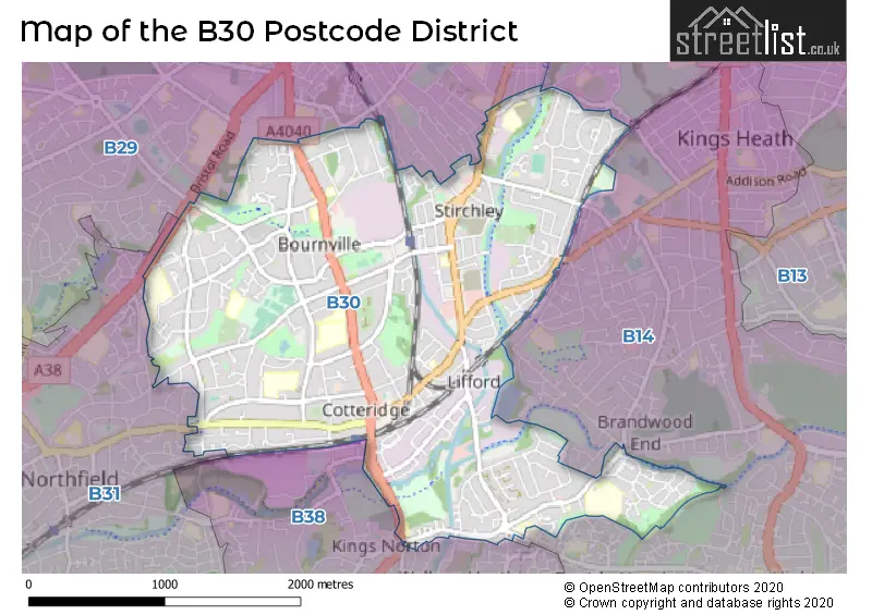
The largest settlement in the B30 postal code is BIRMINGHAM followed by Kings Norton, and Stirchley.
The B30 Postcode shares a border with B13 (BIRMINGHAM, Moseley), B14 (BIRMINGHAM, Kings Heath, Yardley Wood), B29 (BIRMINGHAM, Selly Oak, Selly Park), B31 (BIRMINGHAM, Northfield) and B38 (BIRMINGHAM, Kings Norton).
In the B30 postcode district in Birmingham, West Midlands, the primary settlement is Bournville with a count of 184. Other significant settlements include Kings Norton and Stirchley. Bournville is also the most significant Postal Town in the district.
For the district B30, we have data on 4 postcode sectors. Here's a breakdown: The sector B30 1, covers Birmingham in West Midlands. The sector B30 2, covers Birmingham and Stirchley in West Midlands. The sector B30 3, covers Birmingham and Kings Norton in West Midlands. The sector B30 9 is non-geographic. It's often designated for PO Boxes, large organisations, or special services.

Map of the B30 Postcode District
Explore the B30 postcode district by using our free interactive map.
When it comes to local government, postal geography often disregards political borders. However, for a breakdown in the B30 District: the district mostly encompasses the Birmingham District (B) area with a total of 610 postcodes.
Weather Forecast for B30
Press Button to Show Forecast for Bournville
| Time Period | Icon | Description | Temperature | Rain Probability | Wind |
|---|---|---|---|---|---|
| 06:00 to 09:00 | Overcast | 5.0°C (feels like 2.0°C) | 15.00% | NE 9 mph | |
| 09:00 to 12:00 | Light rain | 6.0°C (feels like 3.0°C) | 56.00% | ENE 9 mph | |
| 12:00 to 15:00 | Light rain | 7.0°C (feels like 4.0°C) | 53.00% | ENE 11 mph | |
| 15:00 to 18:00 | Overcast | 8.0°C (feels like 5.0°C) | 14.00% | NE 11 mph | |
| 18:00 to 21:00 | Overcast | 7.0°C (feels like 4.0°C) | 17.00% | NE 11 mph | |
| 21:00 to 00:00 | Overcast | 6.0°C (feels like 3.0°C) | 13.00% | NE 11 mph |
Press Button to Show Forecast for Bournville
| Time Period | Icon | Description | Temperature | Rain Probability | Wind |
|---|---|---|---|---|---|
| 00:00 to 03:00 | Overcast | 5.0°C (feels like 2.0°C) | 16.00% | NNE 11 mph | |
| 03:00 to 06:00 | Overcast | 5.0°C (feels like 2.0°C) | 19.00% | NNE 11 mph | |
| 06:00 to 09:00 | Light rain | 5.0°C (feels like 2.0°C) | 53.00% | N 11 mph | |
| 09:00 to 12:00 | Heavy rain | 6.0°C (feels like 3.0°C) | 73.00% | NNW 9 mph | |
| 12:00 to 15:00 | Light rain | 8.0°C (feels like 5.0°C) | 50.00% | NW 9 mph | |
| 15:00 to 18:00 | Overcast | 9.0°C (feels like 7.0°C) | 18.00% | WNW 9 mph | |
| 18:00 to 21:00 | Cloudy | 9.0°C (feels like 7.0°C) | 10.00% | WSW 7 mph | |
| 21:00 to 00:00 | Clear night | 7.0°C (feels like 5.0°C) | 3.00% | SW 7 mph |
Press Button to Show Forecast for Bournville
| Time Period | Icon | Description | Temperature | Rain Probability | Wind |
|---|---|---|---|---|---|
| 00:00 to 03:00 | Clear night | 5.0°C (feels like 3.0°C) | 1.00% | SW 4 mph | |
| 03:00 to 06:00 | Clear night | 4.0°C (feels like 1.0°C) | 2.00% | SSW 7 mph | |
| 06:00 to 09:00 | Sunny day | 5.0°C (feels like 2.0°C) | 2.00% | S 7 mph | |
| 09:00 to 12:00 | Partly cloudy (day) | 10.0°C (feels like 7.0°C) | 2.00% | S 11 mph | |
| 12:00 to 15:00 | Overcast | 12.0°C (feels like 9.0°C) | 10.00% | S 13 mph | |
| 15:00 to 18:00 | Cloudy | 13.0°C (feels like 10.0°C) | 7.00% | S 13 mph | |
| 18:00 to 21:00 | Partly cloudy (day) | 12.0°C (feels like 9.0°C) | 4.00% | S 11 mph | |
| 21:00 to 00:00 | Clear night | 9.0°C (feels like 7.0°C) | 3.00% | SSE 9 mph |
Press Button to Show Forecast for Bournville
| Time Period | Icon | Description | Temperature | Rain Probability | Wind |
|---|---|---|---|---|---|
| 00:00 to 03:00 | Clear night | 8.0°C (feels like 5.0°C) | 3.00% | SSE 9 mph | |
| 03:00 to 06:00 | Clear night | 7.0°C (feels like 4.0°C) | 3.00% | SE 9 mph | |
| 06:00 to 09:00 | Sunny day | 7.0°C (feels like 5.0°C) | 4.00% | SE 9 mph | |
| 09:00 to 12:00 | Sunny day | 12.0°C (feels like 9.0°C) | 6.00% | SE 11 mph | |
| 12:00 to 15:00 | Partly cloudy (day) | 14.0°C (feels like 12.0°C) | 11.00% | SE 13 mph | |
| 15:00 to 18:00 | Cloudy | 15.0°C (feels like 13.0°C) | 14.00% | SE 11 mph | |
| 18:00 to 21:00 | Light rain shower (day) | 14.0°C (feels like 12.0°C) | 30.00% | SE 9 mph | |
| 21:00 to 00:00 | Cloudy | 11.0°C (feels like 10.0°C) | 12.00% | ESE 7 mph |
Where is the B30 Postcode District?
The district of B30 is located in Birmingham. It is situated nearby several towns, including Solihull to the East (4.44 miles away), Smethwick to the North West (5.04 miles away), Halesowen to the West (5.68 miles away), Bromsgrove to the South West (7.64 miles away), West Bromwich to the North (7.76 miles away), and Redditch to the South (7.89 miles away). Additionally, B30 is approximately 99.53 miles away from the center of London.
The district is within the post town of BIRMINGHAM.
The sector has postcodes within the nation of England.
The B30 Postcode District is in the Birmingham region of West Midlands within the West Midlands (England).
| Postcode Sector | Delivery Office |
|---|---|
| B30 1 | Kings Norton Delivery Office |
| B30 2 | Kings Norton Delivery Office |
| B30 3 | Kings Norton Delivery Office |
| B | 3 | 0 | - | X | X | X |
| B | 3 | 0 | Space | Numeric | Letter | Letter |
Tourist Attractions within the Postcode Area
We found 2 visitor attractions within the B30 postcode area
| Selly Manor Museum |
|---|
| Museums & Art Galleries |
| Museum and / or Art Gallery |
| View Selly Manor Museum on Google Maps |
| Cadbury World |
| Visitor Centres |
| Heritage / Visitor Centre |
| View Cadbury World on Google Maps |
Current Monthly Rental Prices
| # Bedrooms | Min Price | Max Price | Avg Price |
|---|---|---|---|
| £1,300 | £1,300 | £1,300 | |
| 2 | £950 | £1,400 | £1,146 |
| 3 | £1,200 | £1,300 | £1,233 |
| 4 | £1,295 | £2,080 | £1,736 |
| 5 | £2,000 | £2,000 | £2,000 |
| 6 | £2,940 | £4,600 | £3,770 |
Current House Prices
| # Bedrooms | Min Price | Max Price | Avg Price |
|---|---|---|---|
| 2 | £425,000 | £425,000 | £425,000 |
| 3 | £350,000 | £540,000 | £415,818 |
| 4 | £360,000 | £650,000 | £463,889 |
| 5 | £375,000 | £635,000 | £530,000 |
Estate Agents who Operate in the B30 District
| Logo | Name | Brand Name | Address | Contact Number | Total Properties |
|---|---|---|---|---|---|
 | Bournville | Robert Oulsnam & Company | 235 Mary Vale Road, Bournville, Birmingham, B30 2DL | 0121 387 6380 | 24 |
 | Birmingham | Oakmans Estate Agents | 2, Katie Road, Selly Oak, Birmingham B29 6JG | 0121 387 6514 | 20 |
 | Bournville | Rice Chamberlains LLP | 243 Mary Vale Road, Birmingham, B30 1PN | 0121 387 6338 | 11 |
 | Birmingham | A P Morgan | 1 Devon Way, Northfield, Birmingham, B31 2TS | 0121 387 6717 | 7 |
 | Kings Norton | Dixons | 72 The Green, Kings Norton, Birmingham, West Midlands, B38 8RU | 0121 387 6276 | 6 |
| Type of Property | 2018 Average | 2018 Sales | 2017 Average | 2017 Sales | 2016 Average | 2016 Sales | 2015 Average | 2015 Sales |
|---|---|---|---|---|---|---|---|---|
| Detached | £382,386 | 24 | £359,660 | 28 | £318,778 | 23 | £328,075 | 28 |
| Semi-Detached | £256,554 | 135 | £252,449 | 157 | £217,885 | 125 | £223,838 | 123 |
| Terraced | £204,148 | 238 | £199,642 | 243 | £192,613 | 242 | £171,166 | 267 |
| Flats | £128,780 | 68 | £126,154 | 84 | £148,157 | 164 | £91,309 | 58 |