
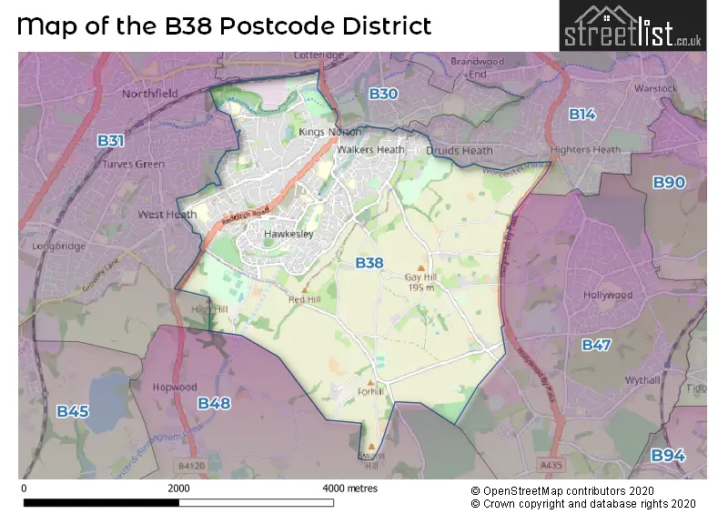
Map of the Postcode District
Explore the postcode district by using our interactive map.
Circles represent recorded crime; the larger the circle, the higher the crime rates.
Your support helps keep this site running!
If you enjoy using this website, consider buying me a coffee to help cover hosting costs.
The postcode district located in the B Birmingham postal area , B38 has a population of 21,117 residents according to the 2021 England and Wales Census.
The area of the district is 5.32 square miles (13.79 square kilometers or 3,407.75 acres).
Where is the B38 District?
To give you an idea where the district is located we have created the following table showing nearby towns.
Nearest Towns to B38
| Town | Distance (miles) | Direction |
|---|---|---|
| Redditch | 5.99 | S |
| Birmingham | 6.04 | N |
| Solihull | 6.38 | ENE |
| Bromsgrove | 6.95 | SW |
| Smethwick | 7.00 | NNW |
| Halesowen | 7.11 | NW |
| Blackheath | 7.54 | NW |
| Rowley Regis | 8.10 | NW |
| Oldbury | 8.66 | NNW |
| Henley-in-Arden | 9.29 | SE |
| West Bromwich | 9.31 | NNW |
| Brierley Hill | 9.38 | NW |
| Stourbridge | 10.18 | WNW |
| Dudley | 10.50 | NW |
| Tipton | 11.34 | NNW |
| Wednesbury | 11.69 | NNW |
| Coleshill | 11.75 | NE |
| Coseley | 12.39 | NNW |
| Kingswinford | 12.49 | NW |
| Royal Sutton Coldfield | 12.53 | NNE |
The post town for this district is BIRMINGHAM.
Postcode Information for District B38 (Total Geographical Postcodes: 640)
| Location | Post Town | Sector | Number of Postcodes |
|---|---|---|---|
| BIRMINGHAM | BIRMINGHAM | B38 9 | 222 |
| BIRMINGHAM | BIRMINGHAM | B38 8 | 214 |
| Kings Norton | BIRMINGHAM | B38 8 | 84 |
| BIRMINGHAM | BIRMINGHAM | B38 0 | 53 |
| Kings Norton | BIRMINGHAM | B38 0 | 34 |
| Kings Norton | BIRMINGHAM | B38 9 | 33 |
Retail and Shopping in B38
Street
Town
Locality
Number of Shops
Central Postcode
View on Google Maps
THE GREEN
BIRMINGHAM
KINGS NORTON
35
B38 8SD
View on Google Maps
THE FOLD
BIRMINGHAM
13
B38 9BL
View on Google Maps
REDDITCH ROAD
BIRMINGHAM
KINGS NORTON
12
B38 8ND
View on Google Maps
HAWKESLEY SQUARE
BIRMINGHAM
7
B38 9TU
View on Google Maps
| Street | Town | Locality | Number of Shops | Central Postcode | View on Google Maps |
|---|---|---|---|---|---|
| THE GREEN | BIRMINGHAM | KINGS NORTON | 35 | B38 8SD | View on Google Maps |
| THE FOLD | BIRMINGHAM | 13 | B38 9BL | View on Google Maps | |
| REDDITCH ROAD | BIRMINGHAM | KINGS NORTON | 12 | B38 8ND | View on Google Maps |
| HAWKESLEY SQUARE | BIRMINGHAM | 7 | B38 9TU | View on Google Maps |
The primary settlement in the B38 postcode district is Kings Norton, which is located in Birmingham, West Midlands. Other significant settlements in the postcode district include Birmingham. The county in which these settlements are located is Worcestershire. The most significant post town in the B38 postcode district is Birmingham.
When it comes to local government, postal geography often disregards political borders. However, this district intersects the following councils: the district mostly encompasses the Birmingham District (B) (428 postal codes), and finally, the Bromsgrove District area (52 postal codes).
The largest settlements in the B38 postal code are BIRMINGHAM and Kings Norton.
The B38 Postcode shares a border with B14 (BIRMINGHAM, Kings Heath, Yardley Wood), B30 (BIRMINGHAM, Kings Norton, Stirchley), B31 (BIRMINGHAM, Northfield) and B48 (Alvechurch, Portway).


Schools in the Sector
St Thomas Aquinas Catholic School
Phase: Secondary
Address: Wychall Lane , Kings Norton , Birmingham
Postcode: B38 8AP
Headteacher: Miss Clare Madden (Headteacher)
Ofsted Rating: Outstanding
St Thomas Aquinas Catholic School
Phase: Secondary
Address: Wychall Lane , Kings Norton , Birmingham
Postcode: B38 8AP
Headteacher: Principal Chris Martin (Headteacher)
Ofsted Rating: Good
West Heath Primary School
Phase: Primary
Address: Rednal Road , West Heath Primary , Birmingham
Postcode: B38 8HU
Headteacher: Mrs Michelle Hooper ()
Ofsted Rating: Good
Kings Norton Nursery School
Phase: Nursery
Address: Westhill Road , Kings Norton , Birmingham
Postcode: B38 8SY
Headteacher: Mrs Nicola Pinnegar (Headteacher)
Ofsted Rating: Outstanding
Fairway Primary Academy
Phase: Primary
Address: Muirfield Gardens , Kings Norton , Birmingham
Postcode: B38 8XQ
Headteacher: Headteacher Darren Mann (Headteacher)
Ofsted Rating: Good
Ark Kings Academy
Phase: All-through
Address: Shannon Road , Kings Norton , Birmingham
Postcode: B38 9DE
Headteacher: Mrs Caz Brasenell (Principal)
Ofsted Rating: Special Measures
New Ways School
Phase: Not applicable
Address: 300 Redhill road , Kings Norton , Birmingham
Postcode: B38 9EL
Headteacher: Miss Michelle Woodward ()
Ofsted Rating: Outstanding
St Paul's Catholic Primary School
Phase: Primary
Address: Sisefield Road , Kings Norton , Birmingham
Postcode: B38 9JB
Headteacher: Mrs Haylia Williams (Headteacher)
Ofsted Rating: Good
Hawkesley Church Primary Academy
Phase: Primary
Address: 376 Shannon Road , Kings Norton , Birmingham
Postcode: B38 9TR
Headteacher: Miss Petrina Poleon ()
Ofsted Rating: Good
Stations in the Sector
No stations found in this postcode district.
Accessable Motorway Junctions
M42 J2
Average Driving Time from within the district: 6.09
Average Driving Distance: 3.72
Number of Postcodes that can access the Motorway Junction: 480
M42 J3
Average Driving Time from within the district: 7.38
Average Driving Distance: 5.08
Number of Postcodes that can access the Motorway Junction: 480
M40 J16
Average Driving Time from within the district: 7.59
Average Driving Distance: 7.08
Number of Postcodes that can access the Motorway Junction: 3
M5 J4
Average Driving Time from within the district: 10.13
Average Driving Distance: 5.99
Number of Postcodes that can access the Motorway Junction: 459
M42 J1
Average Driving Time from within the district: 10.35
Average Driving Distance: 7.79
Number of Postcodes that can access the Motorway Junction: 383
M42 J4
Average Driving Time from within the district: 11.56
Average Driving Distance: 9.66
Number of Postcodes that can access the Motorway Junction: 89
M42 J5
Average Driving Time from within the district: 12.99
Average Driving Distance: 11.90
Number of Postcodes that can access the Motorway Junction: 2
M5 J2
Average Driving Time from within the district: 13.94
Average Driving Distance: 7.83
Number of Postcodes that can access the Motorway Junction: 2
M5 J3
Average Driving Time from within the district: 15.05
Average Driving Distance: 8.34
Number of Postcodes that can access the Motorway Junction: 451
Weather Forecast for King's Norton
| Time Period | Icon | Description | Temperature | Rain Probability | Wind |
|---|---|---|---|---|---|
| 12:00 to 15:00 | Partly cloudy (day) | 13.0°C (feels like 12.0°C) | 3.00% | WSW 9 mph | |
| 15:00 to 18:00 | Sunny day | 14.0°C (feels like 13.0°C) | 2.00% | W 7 mph | |
| 18:00 to 21:00 | Clear night | 12.0°C (feels like 11.0°C) | 0.00% | WSW 2 mph | |
| 21:00 to 00:00 | Clear night | 10.0°C (feels like 9.0°C) | 0.00% | SW 4 mph |
| Time Period | Icon | Description | Temperature | Rain Probability | Wind |
|---|---|---|---|---|---|
| 00:00 to 03:00 | Clear night | 9.0°C (feels like 7.0°C) | 1.00% | SW 4 mph | |
| 03:00 to 06:00 | Cloudy | 8.0°C (feels like 7.0°C) | 18.00% | SSW 7 mph | |
| 06:00 to 09:00 | Mist | 8.0°C (feels like 6.0°C) | 18.00% | SSW 7 mph | |
| 09:00 to 12:00 | Overcast | 10.0°C (feels like 8.0°C) | 11.00% | SSW 7 mph | |
| 12:00 to 15:00 | Overcast | 12.0°C (feels like 10.0°C) | 7.00% | SSW 9 mph | |
| 15:00 to 18:00 | Cloudy | 14.0°C (feels like 12.0°C) | 5.00% | SSW 9 mph | |
| 18:00 to 21:00 | Partly cloudy (night) | 12.0°C (feels like 10.0°C) | 1.00% | S 9 mph | |
| 21:00 to 00:00 | Partly cloudy (night) | 10.0°C (feels like 8.0°C) | 1.00% | SSE 9 mph |
| Time Period | Icon | Description | Temperature | Rain Probability | Wind |
|---|---|---|---|---|---|
| 00:00 to 03:00 | Partly cloudy (night) | 9.0°C (feels like 7.0°C) | 1.00% | SSE 11 mph | |
| 03:00 to 06:00 | Partly cloudy (night) | 9.0°C (feels like 7.0°C) | 1.00% | SSE 11 mph | |
| 06:00 to 09:00 | Clear night | 9.0°C (feels like 6.0°C) | 1.00% | SSE 11 mph | |
| 09:00 to 12:00 | Overcast | 11.0°C (feels like 8.0°C) | 7.00% | SSE 13 mph | |
| 12:00 to 15:00 | Overcast | 13.0°C (feels like 10.0°C) | 8.00% | SSE 16 mph | |
| 15:00 to 18:00 | Overcast | 14.0°C (feels like 12.0°C) | 8.00% | SSE 13 mph | |
| 18:00 to 21:00 | Overcast | 13.0°C (feels like 11.0°C) | 12.00% | SSE 13 mph | |
| 21:00 to 00:00 | Overcast | 13.0°C (feels like 11.0°C) | 24.00% | S 13 mph |
| Time Period | Icon | Description | Temperature | Rain Probability | Wind |
|---|---|---|---|---|---|
| 00:00 to 03:00 | Light rain | 13.0°C (feels like 10.0°C) | 54.00% | S 13 mph | |
| 03:00 to 06:00 | Light rain shower (night) | 11.0°C (feels like 9.0°C) | 35.00% | SSW 13 mph | |
| 06:00 to 09:00 | Partly cloudy (night) | 10.0°C (feels like 8.0°C) | 7.00% | SSW 11 mph | |
| 09:00 to 12:00 | Partly cloudy (day) | 10.0°C (feels like 8.0°C) | 6.00% | SSW 11 mph | |
| 12:00 to 15:00 | Partly cloudy (day) | 12.0°C (feels like 9.0°C) | 15.00% | SSW 11 mph | |
| 15:00 to 18:00 | Light rain shower (day) | 11.0°C (feels like 9.0°C) | 40.00% | SSW 11 mph | |
| 18:00 to 21:00 | Clear night | 9.0°C (feels like 7.0°C) | 9.00% | SW 9 mph | |
| 21:00 to 00:00 | Partly cloudy (night) | 8.0°C (feels like 5.0°C) | 6.00% | SW 11 mph |
| Time Period | Icon | Description | Temperature | Rain Probability | Wind |
|---|---|---|---|---|---|
| 00:00 to 03:00 | Partly cloudy (night) | 7.0°C (feels like 4.0°C) | 3.00% | SW 11 mph | |
| 03:00 to 06:00 | Cloudy | 7.0°C (feels like 4.0°C) | 7.00% | SW 11 mph | |
| 06:00 to 09:00 | Cloudy | 7.0°C (feels like 4.0°C) | 13.00% | SSW 11 mph | |
| 09:00 to 12:00 | Cloudy | 9.0°C (feels like 6.0°C) | 13.00% | SW 13 mph | |
| 12:00 to 15:00 | Cloudy | 11.0°C (feels like 8.0°C) | 15.00% | SW 13 mph | |
| 15:00 to 18:00 | Cloudy | 11.0°C (feels like 9.0°C) | 15.00% | SW 13 mph | |
| 18:00 to 21:00 | Partly cloudy (night) | 10.0°C (feels like 7.0°C) | 11.00% | SW 11 mph | |
| 21:00 to 00:00 | Clear night | 9.0°C (feels like 7.0°C) | 5.00% | WSW 11 mph |
| Postal Sector | Delivery Office |
|---|---|
| B38 0 | Kings Norton Delivery Office |
| B38 8 | Kings Norton Delivery Office |
| B38 9 | Kings Norton Delivery Office |
| B | 3 | 8 | - | X | X | X |
| B | 3 | 8 | Space | Numeric | Letter | Letter |
Street List for the B38 District
Current Monthly Rental Prices
| # Bedrooms | Min Price | Max Price | Avg Price |
|---|---|---|---|
| 2 | £750 | £1,650 | £1,065 |
| 3 | £925 | £950 | £938 |
| 4 | £1,750 | £1,750 | £1,750 |
| 7 | £3,700 | £3,700 | £3,700 |
Current House Prices
| # Bedrooms | Min Price | Max Price | Avg Price |
|---|---|---|---|
| 3 | £365,000 | £625,000 | £500,000 |
| 4 | £350,000 | £850,000 | £628,608 |
| 6 | £850,000 | £850,000 | £850,000 |
| 7 | £1,000,000 | £1,050,000 | £1,025,000 |
Estate Agents
| Logo | Name | Brand Name | Address | Contact Number |
|---|---|---|---|---|
 | Birmingham | A P Morgan | 1 Devon Way, Northfield, Birmingham, B31 2TS | 0121 387 6717 |
 | Birmingham | Oakmans Estate Agents | 2, Katie Road, Selly Oak, Birmingham B29 6JG | 0121 387 6514 |
 | Kings Norton | Dixons | 72 The Green, Kings Norton, Birmingham, West Midlands, B38 8RU | 0121 387 6276 |
 | West Midlands | Yopa | Meridian House Wheatfield Way Hinckley LE10 1YG | 01525 659945 |
 | Kings Norton | Leaders Sales | 1880 Pershore Road, Kings Norton, Birmingham, B30 3AS | 0121 387 6344 |
Yearly House Price Averages for the District
| Type of Property | 2018 Average | 2018 Sales | 2017 Average | 2017 Sales | 2016 Average | 2016 Sales | 2015 Average | 2015 Sales |
|---|---|---|---|---|---|---|---|---|
| Detached | £322,740 | 29 | £344,708 | 37 | £316,604 | 35 | £314,907 | 50 |
| Semi-Detached | £197,413 | 103 | £195,677 | 97 | £180,510 | 112 | £178,986 | 91 |
| Terraced | £155,650 | 129 | £137,263 | 120 | £136,969 | 123 | £130,664 | 118 |
| Flats | £102,745 | 42 | £111,204 | 38 | £112,954 | 51 | £90,516 | 35 |