The B48 postcode district is a postal district located in the B Birmingham postcode area with a population of 6,055 residents according to the 2021 England and Wales Census.
The area of the B48 postcode district is 11.98 square miles which is 31.03 square kilometres or 7,667.69 acres.
Currently, the B48 district has about 208 postcode units spread across 1 geographic postcode sectors.
Given that each sector allows for 400 unique postcode combinations, the district has a capacity of 400 postcodes. With 208 postcodes already in use, this leaves 192 units available.
The largest settlements in the B48 postal code are Alvechurch and Portway.
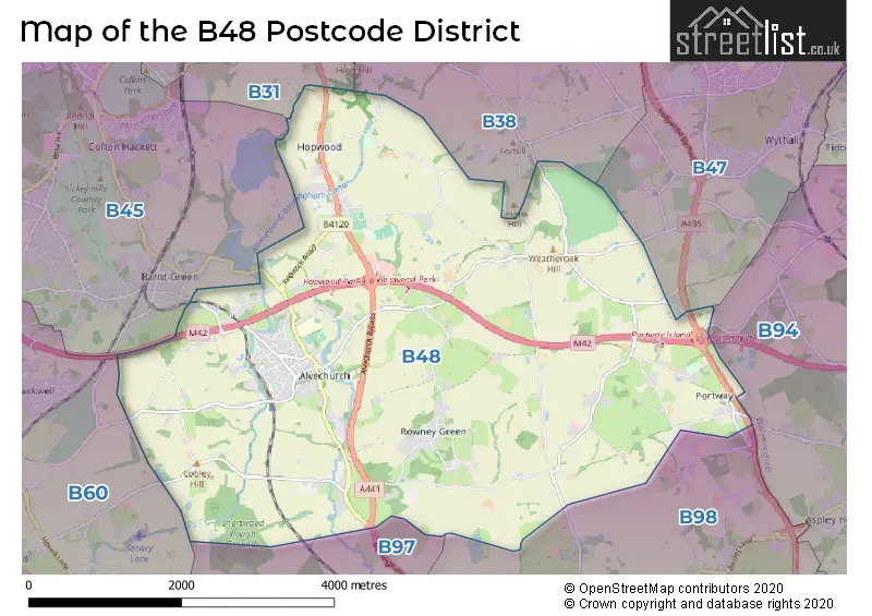
The B48 Postcode shares a border with B97 (REDDITCH, Callow Hill, Kingfisher Shopping Centre), B98 (REDDITCH, Beoley, Moons Moat North Industrial Estate), B31 (BIRMINGHAM, Northfield), B38 (BIRMINGHAM, Kings Norton) and B45 (Rednal, Barnt Green, Cofton Hackett).
The primary settlement in the B48 postcode district is Alvechurch, located in Worcestershire, England. The most significant post town in this postcode district is Birmingham.
For the district B48, we have data on 1 postcode sectors. Here's a breakdown: The sector B48 7, covers Alvechurch in Worcestershire.
B48 Postcode Sectors

Map of the B48 Postcode District
Explore the B48 postcode district by using our free interactive map.
When it comes to local government, postal geography often disregards political borders. However, for a breakdown in the B48 District: the district mostly encompasses the Bromsgrove District area with a total of 206 postcodes.
Weather Forecast for B48
Press Button to Show Forecast for West Heath
| Time Period | Icon | Description | Temperature | Rain Probability | Wind |
|---|---|---|---|---|---|
| 06:00 to 09:00 | Overcast | 5.0°C (feels like 1.0°C) | 17.00% | NE 9 mph | |
| 09:00 to 12:00 | Light rain | 6.0°C (feels like 3.0°C) | 56.00% | ENE 9 mph | |
| 12:00 to 15:00 | Light rain | 7.0°C (feels like 3.0°C) | 52.00% | ENE 11 mph | |
| 15:00 to 18:00 | Overcast | 7.0°C (feels like 4.0°C) | 15.00% | NE 11 mph | |
| 18:00 to 21:00 | Overcast | 7.0°C (feels like 4.0°C) | 19.00% | NE 11 mph | |
| 21:00 to 00:00 | Overcast | 6.0°C (feels like 3.0°C) | 13.00% | NE 11 mph |
Press Button to Show Forecast for West Heath
| Time Period | Icon | Description | Temperature | Rain Probability | Wind |
|---|---|---|---|---|---|
| 00:00 to 03:00 | Overcast | 5.0°C (feels like 1.0°C) | 16.00% | NNE 11 mph | |
| 03:00 to 06:00 | Overcast | 5.0°C (feels like 1.0°C) | 19.00% | NNE 11 mph | |
| 06:00 to 09:00 | Light rain | 5.0°C (feels like 1.0°C) | 53.00% | N 11 mph | |
| 09:00 to 12:00 | Heavy rain | 6.0°C (feels like 3.0°C) | 73.00% | NNW 11 mph | |
| 12:00 to 15:00 | Light rain | 8.0°C (feels like 5.0°C) | 51.00% | NW 11 mph | |
| 15:00 to 18:00 | Overcast | 9.0°C (feels like 7.0°C) | 18.00% | WNW 9 mph | |
| 18:00 to 21:00 | Cloudy | 9.0°C (feels like 7.0°C) | 10.00% | WSW 9 mph | |
| 21:00 to 00:00 | Clear night | 6.0°C (feels like 4.0°C) | 3.00% | SW 7 mph |
Press Button to Show Forecast for West Heath
| Time Period | Icon | Description | Temperature | Rain Probability | Wind |
|---|---|---|---|---|---|
| 00:00 to 03:00 | Clear night | 4.0°C (feels like 2.0°C) | 1.00% | SW 7 mph | |
| 03:00 to 06:00 | Clear night | 4.0°C (feels like 0.0°C) | 2.00% | SSW 9 mph | |
| 06:00 to 09:00 | Sunny day | 5.0°C (feels like 1.0°C) | 2.00% | S 9 mph | |
| 09:00 to 12:00 | Partly cloudy (day) | 9.0°C (feels like 7.0°C) | 2.00% | S 13 mph | |
| 12:00 to 15:00 | Overcast | 12.0°C (feels like 9.0°C) | 10.00% | S 16 mph | |
| 15:00 to 18:00 | Cloudy | 13.0°C (feels like 10.0°C) | 7.00% | S 16 mph | |
| 18:00 to 21:00 | Partly cloudy (day) | 12.0°C (feels like 9.0°C) | 4.00% | S 13 mph | |
| 21:00 to 00:00 | Clear night | 9.0°C (feels like 6.0°C) | 3.00% | SSE 11 mph |
Press Button to Show Forecast for West Heath
| Time Period | Icon | Description | Temperature | Rain Probability | Wind |
|---|---|---|---|---|---|
| 00:00 to 03:00 | Clear night | 7.0°C (feels like 4.0°C) | 3.00% | SSE 11 mph | |
| 03:00 to 06:00 | Clear night | 7.0°C (feels like 3.0°C) | 2.00% | SE 11 mph | |
| 06:00 to 09:00 | Sunny day | 7.0°C (feels like 4.0°C) | 5.00% | SE 11 mph | |
| 09:00 to 12:00 | Sunny day | 11.0°C (feels like 9.0°C) | 6.00% | SE 11 mph | |
| 12:00 to 15:00 | Partly cloudy (day) | 14.0°C (feels like 11.0°C) | 11.00% | SE 13 mph | |
| 15:00 to 18:00 | Cloudy | 15.0°C (feels like 12.0°C) | 14.00% | SE 13 mph | |
| 18:00 to 21:00 | Light rain shower (day) | 14.0°C (feels like 12.0°C) | 30.00% | SE 11 mph | |
| 21:00 to 00:00 | Cloudy | 11.0°C (feels like 9.0°C) | 12.00% | ESE 9 mph |
Where is the B48 Postcode District?
The postcode district B48 is located in Birmingham. It is surrounded by several nearby towns, including Redditch to the south, Bromsgrove to the west, Solihull to the northeast, Henley-in-Arden to the southeast, Halesowen to the northwest, and Smethwick to the north. The distance from B48 to the center of London is approximately 97.02 miles.
The district is within the post town of BIRMINGHAM.
The sector has postcodes within the nation of England.
The B48 Postcode District is covers the following regions.
- Worcestershire - Herefordshire, Worcestershire and Warwickshire - West Midlands (England)
- Birmingham - West Midlands - West Midlands (England)
- Warwickshire - Herefordshire, Worcestershire and Warwickshire - West Midlands (England)
Postcode Sectors within the B48 District
| Postcode Sector | Delivery Office |
|---|---|
| B48 7 | Rednal Delivery Office |
| B | 4 | 8 | - | X | X | X |
| B | 4 | 8 | Space | Numeric | Letter | Letter |
Current Monthly Rental Prices
| # Bedrooms | Min Price | Max Price | Avg Price |
|---|---|---|---|
| 3 | £1,300 | £1,450 | £1,378 |
| 4 | £3,000 | £3,000 | £3,000 |
Current House Prices
| # Bedrooms | Min Price | Max Price | Avg Price |
|---|---|---|---|
| £440,000 | £1,800,000 | £1,120,000 | |
| 2 | £290,000 | £330,000 | £310,000 |
| 3 | £349,000 | £650,000 | £437,395 |
| 4 | £420,000 | £800,000 | £601,875 |
| 5 | £1,050,000 | £1,400,000 | £1,225,000 |
| 10 | £1,600,000 | £1,600,000 | £1,600,000 |
Estate Agents who Operate in the B48 District
| Logo | Name | Brand Name | Address | Contact Number | Total Properties |
|---|---|---|---|---|---|
 | Barnt Green | Arden Estates | 67 Hewell Road, Barnt Green, B45 8NL | 0121 387 6453 | 9 |
 | Barnt Green | Robert Oulsnam & Company | 79 Hewell Road, Barnt Green, B45 8NL | 0121 387 6691 | 5 |
 | Redditch | A P Morgan | Estate House, 12 Church Green East, Redditch, B98 8BP | 01527 913195 | 3 |
 | Redditch | Hunters | 7 Church Green East, Redditch, B98 8BP | 01527 919205 | 2 |
 | Rubery | Dunedin Sales & Lettings | 2046 - 2048 Bristol Road South, Rubery, Rednal, Birmingham, B45 9JL | 0121 387 6482 | 2 |
| Type of Property | 2018 Average | 2018 Sales | 2017 Average | 2017 Sales | 2016 Average | 2016 Sales | 2015 Average | 2015 Sales |
|---|---|---|---|---|---|---|---|---|
| Detached | £590,657 | 22 | £492,282 | 24 | £468,206 | 44 | £519,079 | 31 |
| Semi-Detached | £335,631 | 26 | £287,841 | 39 | £276,909 | 40 | £302,856 | 33 |
| Terraced | £251,423 | 13 | £243,036 | 33 | £209,568 | 46 | £231,440 | 25 |
| Flats | £197,500 | 2 | £125,000 | 1 | £0 | 0 | £140,000 | 1 |