The B48 7 postcode sector stands on the Warwickshire and Worcestershire border.
Did you know? According to the 2021 Census, the B48 7 postcode sector is home to a bustling 6,055 residents!
Given that each sector allows for 400 unique postcode combinations. Letters C, I, K, M, O and V are not allowed in the last two letters of a postcode. With 208 postcodes already in use, this leaves 192 units available.
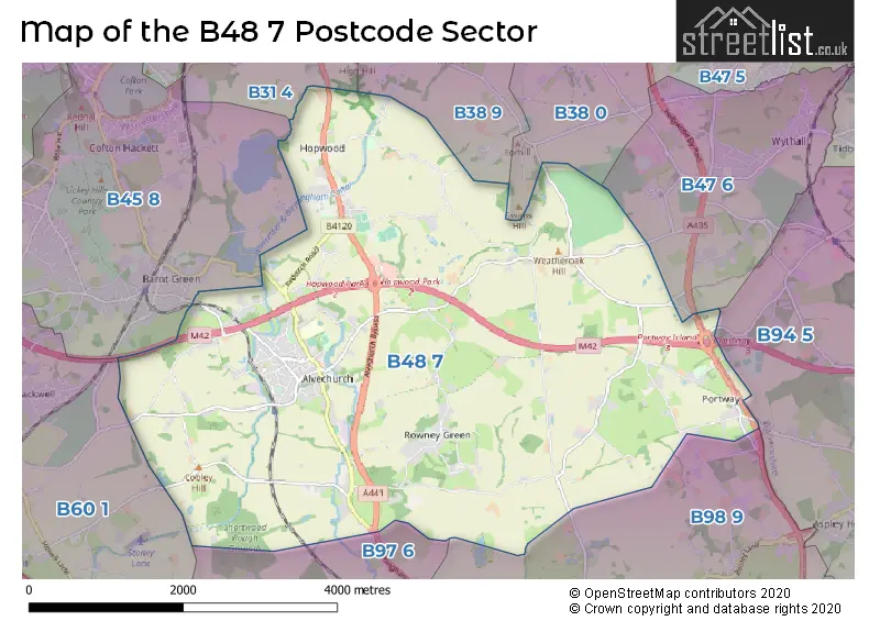
The largest settlements in the B48 7 postal code are Alvechurch and Portway.
The B48 7 Postcode shares a border with B94 5 (Earlswood, Tanworth-in-Arden, Lapworth), B97 6 (REDDITCH), B31 4 (BIRMINGHAM, Northfield), B38 0 (BIRMINGHAM, Kings Norton), B38 9 (BIRMINGHAM, Kings Norton), B45 8 (Rednal, Barnt Green, Cofton Hackett), B47 6 (Wythall), B60 1 (Marlbrook, Lickey End, BROMSGROVE) and B98 9 (REDDITCH, Beoley, Moons Moat North Industrial Estate).
The sector is within the post town of BIRMINGHAM.
B48 7 is a postcode sector within the B48 postcode district which is within the B Birmingham postcode area.
The Royal Mail delivery office for the B48 7 postal sector is the Rednal Delivery Office.
The area of the B48 7 postcode sector is 11.98 square miles which is 31.03 square kilometres or 7,667.69 square acres.
The B48 7 postcode sector is crossed by the M42 motorway.
The B48 7 postcode sector is crossed by the A435 Major A road.
Waterways within the B48 7 postcode sector include the Worcester & Birmingham Canal, Wast Hill Tunnel, River Arrow.

Map of the B48 7 Postcode Sector
Explore the B48 7 postcode sector by using our free interactive map.
| B | 4 | 8 | - | 7 | X | X |
| B | 4 | 8 | Space | 7 | Letter | Letter |
Official List of Streets
Portway (3 Streets)
Alvechurch (94 Streets)
Unofficial Streets or Alternative Spellings
Earlswood
FORSHAW HEATH LANEBeoley
ALCESTER ROADREDDITCH
BIRMINGHAM ROAD ALVECHURCH BYPASS BEARHILL DRIVE BILLELSLEY LANE CANAL SIDE COBBS BARN ROUNDABOUT DUMBLEPITS LANE FORWARD COTTAGES HOPWOOD PARK INTERCHANGE HOPWOOD PARK SERVICES JAYS CRESCENT LOWER PARK FARM OLD TRACK, UNMANAGED OLD TRACK, UNMANAGED. PORTWAY ISLAND PORTWAY PATHS SWANS LENGTH THE LAWNSKings Norton
WASTHILL LANEWeather Forecast for B48 7
Press Button to Show Forecast for West Heath
| Time Period | Icon | Description | Temperature | Rain Probability | Wind |
|---|---|---|---|---|---|
| 09:00 to 12:00 | Light rain | 6.0°C (feels like 3.0°C) | 56.00% | ENE 9 mph | |
| 12:00 to 15:00 | Light rain | 7.0°C (feels like 3.0°C) | 52.00% | ENE 11 mph | |
| 15:00 to 18:00 | Overcast | 7.0°C (feels like 4.0°C) | 15.00% | NE 11 mph | |
| 18:00 to 21:00 | Overcast | 7.0°C (feels like 4.0°C) | 19.00% | NE 11 mph | |
| 21:00 to 00:00 | Overcast | 6.0°C (feels like 3.0°C) | 13.00% | NE 11 mph |
Press Button to Show Forecast for West Heath
| Time Period | Icon | Description | Temperature | Rain Probability | Wind |
|---|---|---|---|---|---|
| 00:00 to 03:00 | Overcast | 5.0°C (feels like 1.0°C) | 16.00% | NNE 11 mph | |
| 03:00 to 06:00 | Overcast | 5.0°C (feels like 1.0°C) | 19.00% | NNE 11 mph | |
| 06:00 to 09:00 | Light rain | 5.0°C (feels like 1.0°C) | 53.00% | N 11 mph | |
| 09:00 to 12:00 | Heavy rain | 6.0°C (feels like 3.0°C) | 73.00% | NNW 11 mph | |
| 12:00 to 15:00 | Light rain | 8.0°C (feels like 5.0°C) | 51.00% | NW 11 mph | |
| 15:00 to 18:00 | Overcast | 9.0°C (feels like 7.0°C) | 18.00% | WNW 9 mph | |
| 18:00 to 21:00 | Cloudy | 9.0°C (feels like 7.0°C) | 10.00% | WSW 9 mph | |
| 21:00 to 00:00 | Clear night | 6.0°C (feels like 4.0°C) | 3.00% | SW 7 mph |
Press Button to Show Forecast for West Heath
| Time Period | Icon | Description | Temperature | Rain Probability | Wind |
|---|---|---|---|---|---|
| 00:00 to 03:00 | Clear night | 4.0°C (feels like 2.0°C) | 1.00% | SW 7 mph | |
| 03:00 to 06:00 | Clear night | 4.0°C (feels like 0.0°C) | 2.00% | SSW 9 mph | |
| 06:00 to 09:00 | Sunny day | 5.0°C (feels like 1.0°C) | 2.00% | S 9 mph | |
| 09:00 to 12:00 | Partly cloudy (day) | 9.0°C (feels like 7.0°C) | 2.00% | S 13 mph | |
| 12:00 to 15:00 | Overcast | 12.0°C (feels like 9.0°C) | 10.00% | S 16 mph | |
| 15:00 to 18:00 | Cloudy | 13.0°C (feels like 10.0°C) | 7.00% | S 16 mph | |
| 18:00 to 21:00 | Partly cloudy (day) | 12.0°C (feels like 9.0°C) | 4.00% | S 13 mph | |
| 21:00 to 00:00 | Clear night | 9.0°C (feels like 6.0°C) | 3.00% | SSE 11 mph |
Press Button to Show Forecast for West Heath
| Time Period | Icon | Description | Temperature | Rain Probability | Wind |
|---|---|---|---|---|---|
| 00:00 to 03:00 | Clear night | 7.0°C (feels like 4.0°C) | 3.00% | SSE 11 mph | |
| 03:00 to 06:00 | Clear night | 7.0°C (feels like 3.0°C) | 2.00% | SE 11 mph | |
| 06:00 to 09:00 | Sunny day | 7.0°C (feels like 4.0°C) | 5.00% | SE 11 mph | |
| 09:00 to 12:00 | Sunny day | 11.0°C (feels like 9.0°C) | 6.00% | SE 11 mph | |
| 12:00 to 15:00 | Partly cloudy (day) | 14.0°C (feels like 11.0°C) | 11.00% | SE 13 mph | |
| 15:00 to 18:00 | Cloudy | 15.0°C (feels like 12.0°C) | 14.00% | SE 13 mph | |
| 18:00 to 21:00 | Light rain shower (day) | 14.0°C (feels like 12.0°C) | 30.00% | SE 11 mph | |
| 21:00 to 00:00 | Cloudy | 11.0°C (feels like 9.0°C) | 12.00% | ESE 9 mph |
Schools and Places of Education Within the B48 7 Postcode Sector
Alvechurch CofE Middle School
Academy converter
Birmingham Road, Birmingham, West Midlands, B48 7TA
Head: Mr David Snell
Ofsted Rating: Good
Inspection: 2020-01-29 (1550 days ago)
Website: Visit Alvechurch CofE Middle School Website
Phone: 01214451033
Number of Pupils: 439
Crown Meadow First School & Nursery
Community school
Birmingham Road, Birmingham, West Midlands, B48 7TA
Head: Mrs Sally Athey
Ofsted Rating: Good
Inspection: 2021-11-25 (884 days ago)
Website: Visit Crown Meadow First School & Nursery Website
Phone: 01214454540
Number of Pupils: 332
House Prices in the B48 7 Postcode Sector
| Type of Property | 2018 Average | 2018 Sales | 2017 Average | 2017 Sales | 2016 Average | 2016 Sales | 2015 Average | 2015 Sales |
|---|---|---|---|---|---|---|---|---|
| Detached | £590,657 | 22 | £492,282 | 24 | £468,206 | 44 | £519,079 | 31 |
| Semi-Detached | £335,631 | 26 | £287,841 | 39 | £276,909 | 40 | £302,856 | 33 |
| Terraced | £251,423 | 13 | £243,036 | 33 | £209,568 | 46 | £231,440 | 25 |
| Flats | £197,500 | 2 | £125,000 | 1 | £0 | 0 | £140,000 | 1 |
Important Postcodes B48 7 in the Postcode Sector
B48 7LA is the postcode for Alvechurch Medical Centre, 5 The Square
B48 7TA is the postcode for Alvechurch Middle & Crown Meadow Schools, Birmingham Road, Alvechurch, and Alvechurch Middle & Crown Meadow Schools, Birmingham Road
| The B48 7 Sector is within these Local Authorities |
|
|---|---|
| The B48 7 Sector is within these Counties |
|
| The B48 7 Sector is within these Water Company Areas |
|