The B13 postcode district is a postal district located in the B Birmingham postcode area with a population of 38,683 residents according to the 2021 England and Wales Census.
The area of the B13 postcode district is 3.59 square miles which is 9.31 square kilometres or 2,299.96 acres.
Currently, the B13 district has about 669 postcode units spread across 3 geographic postcode sectors.
Given that each sector allows for 400 unique postcode combinations, the district has a capacity of 1,200 postcodes. With 669 postcodes already in use, this leaves 531 units available.
The largest settlements in the B13 postal code are BIRMINGHAM and Moseley.
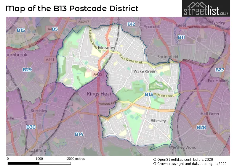
The B13 Postcode shares a border with B28 (BIRMINGHAM, Hall Green), B11 (BIRMINGHAM, Sparkhill, Tyseley), B12 (BIRMINGHAM, Balsall Heath, Deritend), B14 (BIRMINGHAM, Kings Heath, Yardley Wood) and B30 (BIRMINGHAM, Kings Norton, Stirchley).
The primary settlement in the B13 postcode district is Moseley, located in the city of Birmingham in the West Midlands. Other significant settlements in this area include Kings Heath. Moseley and Kings Heath are both located within the county of West Midlands in England. The main post town for this postcode district is Birmingham.
For the district B13, we have data on 4 postcode sectors. Here's a breakdown: The sector B13 0, covers Birmingham in West Midlands. The sector B13 3 is non-geographic. It's often designated for PO Boxes, large organisations, or special services. The sector B13 8, covers Birmingham and Moseley in West Midlands. The sector B13 9, covers Birmingham and Moseley in West Midlands.

Map of the B13 Postcode District
Explore the B13 postcode district by using our free interactive map.
When it comes to local government, postal geography often disregards political borders. However, for a breakdown in the B13 District: the district mostly encompasses the Birmingham District (B) area with a total of 672 postcodes.
Weather Forecast for B13
Press Button to Show Forecast for Wake Green
| Time Period | Icon | Description | Temperature | Rain Probability | Wind |
|---|---|---|---|---|---|
| 09:00 to 12:00 | Light rain | 6.0°C (feels like 3.0°C) | 56.00% | ENE 11 mph | |
| 12:00 to 15:00 | Overcast | 7.0°C (feels like 3.0°C) | 53.00% | ENE 11 mph | |
| 15:00 to 18:00 | Overcast | 7.0°C (feels like 4.0°C) | 14.00% | NE 11 mph | |
| 18:00 to 21:00 | Overcast | 7.0°C (feels like 4.0°C) | 16.00% | NE 11 mph | |
| 21:00 to 00:00 | Overcast | 6.0°C (feels like 3.0°C) | 12.00% | NE 11 mph |
Press Button to Show Forecast for Wake Green
| Time Period | Icon | Description | Temperature | Rain Probability | Wind |
|---|---|---|---|---|---|
| 00:00 to 03:00 | Overcast | 5.0°C (feels like 2.0°C) | 15.00% | NNE 11 mph | |
| 03:00 to 06:00 | Overcast | 5.0°C (feels like 1.0°C) | 19.00% | NNE 11 mph | |
| 06:00 to 09:00 | Light rain | 5.0°C (feels like 1.0°C) | 55.00% | N 11 mph | |
| 09:00 to 12:00 | Heavy rain | 6.0°C (feels like 3.0°C) | 73.00% | NNW 11 mph | |
| 12:00 to 15:00 | Light rain | 8.0°C (feels like 5.0°C) | 51.00% | NW 11 mph | |
| 15:00 to 18:00 | Overcast | 9.0°C (feels like 7.0°C) | 18.00% | WNW 9 mph | |
| 18:00 to 21:00 | Cloudy | 9.0°C (feels like 7.0°C) | 10.00% | WSW 9 mph | |
| 21:00 to 00:00 | Clear night | 7.0°C (feels like 4.0°C) | 3.00% | SW 7 mph |
Press Button to Show Forecast for Wake Green
| Time Period | Icon | Description | Temperature | Rain Probability | Wind |
|---|---|---|---|---|---|
| 00:00 to 03:00 | Clear night | 5.0°C (feels like 2.0°C) | 1.00% | SW 7 mph | |
| 03:00 to 06:00 | Clear night | 4.0°C (feels like 1.0°C) | 2.00% | SSW 9 mph | |
| 06:00 to 09:00 | Sunny day | 5.0°C (feels like 1.0°C) | 2.00% | S 9 mph | |
| 09:00 to 12:00 | Partly cloudy (day) | 9.0°C (feels like 7.0°C) | 2.00% | S 13 mph | |
| 12:00 to 15:00 | Overcast | 12.0°C (feels like 9.0°C) | 10.00% | S 16 mph | |
| 15:00 to 18:00 | Cloudy | 13.0°C (feels like 10.0°C) | 7.00% | S 16 mph | |
| 18:00 to 21:00 | Partly cloudy (day) | 12.0°C (feels like 9.0°C) | 4.00% | S 13 mph | |
| 21:00 to 00:00 | Clear night | 9.0°C (feels like 6.0°C) | 3.00% | SSE 11 mph |
Press Button to Show Forecast for Wake Green
| Time Period | Icon | Description | Temperature | Rain Probability | Wind |
|---|---|---|---|---|---|
| 00:00 to 03:00 | Clear night | 7.0°C (feels like 4.0°C) | 3.00% | SSE 11 mph | |
| 03:00 to 06:00 | Clear night | 7.0°C (feels like 3.0°C) | 3.00% | SE 11 mph | |
| 06:00 to 09:00 | Sunny day | 7.0°C (feels like 4.0°C) | 4.00% | SE 11 mph | |
| 09:00 to 12:00 | Sunny day | 11.0°C (feels like 9.0°C) | 6.00% | SE 11 mph | |
| 12:00 to 15:00 | Partly cloudy (day) | 14.0°C (feels like 11.0°C) | 11.00% | SE 13 mph | |
| 15:00 to 18:00 | Cloudy | 15.0°C (feels like 12.0°C) | 15.00% | SE 13 mph | |
| 18:00 to 21:00 | Light rain shower (day) | 14.0°C (feels like 12.0°C) | 30.00% | SE 11 mph | |
| 21:00 to 00:00 | Cloudy | 11.0°C (feels like 9.0°C) | 12.00% | ESE 9 mph |
Where is the B13 Postcode District?
The given postcode, B13, belongs to the district town of Birmingham. This postcode district is located near several towns. To the east is Solihull, which is approximately 2.47 miles away. To the northwest is Smethwick, which is about 5.34 miles away. Halesowen is located to the west, about 7.48 miles away. Redditch is located to the south, approximately 9.22 miles away. Lastly, Sutton Coldfield is located to the north, roughly 9.34 miles away. Additionally, the distance from the postcode district B13 to the center of London is about 98.65 miles.
The district is within the post town of BIRMINGHAM.
The sector has postcodes within the nation of England.
The B13 Postcode District is in the Birmingham region of West Midlands within the West Midlands (England).
| Postcode Sector | Delivery Office |
|---|---|
| B13 0 | Moseley Delivery Office |
| B13 8 | Moseley Delivery Office |
| B13 9 | Moseley Delivery Office |
| B | 1 | 3 | - | X | X | X |
| B | 1 | 3 | Space | Numeric | Letter | Letter |
Tourist Attractions within the Postcode Area
We found 1 visitor attractions within the B13 postcode area
| Sarehole Mill |
|---|
| Museums & Art Galleries |
| Museum and / or Art Gallery |
| View Sarehole Mill on Google Maps |
Current Monthly Rental Prices
| # Bedrooms | Min Price | Max Price | Avg Price |
|---|---|---|---|
| £695 | £949 | £798 | |
| 1 | £40 | £2,399 | £1,166 |
| 2 | £900 | £1,200 | £1,130 |
| 3 | £650 | £1,350 | £1,092 |
| 4 | £1,350 | £1,650 | £1,467 |
| 5 | £1,100 | £3,000 | £1,950 |
Current House Prices
| # Bedrooms | Min Price | Max Price | Avg Price |
|---|---|---|---|
| 3 | £210,000 | £245,000 | £227,500 |
| 4 | £725,000 | £725,000 | £725,000 |
| 5 | £725,000 | £1,000,000 | £850,000 |
| 6 | £740,000 | £1,200,000 | £925,909 |
| 7 | £875,000 | £1,450,000 | £1,162,500 |
| 9 | £890,000 | £890,000 | £890,000 |
Estate Agents who Operate in the B13 District
| Logo | Name | Brand Name | Address | Contact Number | Total Properties |
|---|---|---|---|---|---|
 | Moseley | Robert Oulsnam & Company | 142 Alcester Road, Moseley, Birmingham, B13 8HS | 0121 387 6395 | 34 |
 | Moseley | Rice Chamberlains LLP | 27/29 St Marys Row, Moseley, Birmingham, B13 8HW | 0121 387 6675 | 33 |
 | Kings Heath | Glovers Estate Agents | 33 High Street, Kings Heath, Birmingham, B14 7BB | 0121 443 4343 | 8 |
 | London | OpenRent | 39 Great Windmill Street London W1D 7LX | 020 3322 3265 | 8 |
 | Moseley | Dixons | 95 Alcester Road, Birmingham, West Midlands, B13 8DD | 0121 387 6278 | 8 |
| Type of Property | 2018 Average | 2018 Sales | 2017 Average | 2017 Sales | 2016 Average | 2016 Sales | 2015 Average | 2015 Sales |
|---|---|---|---|---|---|---|---|---|
| Detached | £445,268 | 53 | £481,349 | 61 | £434,094 | 62 | £416,481 | 65 |
| Semi-Detached | £346,786 | 99 | £335,554 | 114 | £289,387 | 104 | £279,901 | 85 |
| Terraced | £212,029 | 146 | £221,206 | 151 | £197,325 | 131 | £191,418 | 175 |
| Flats | £143,984 | 164 | £132,649 | 171 | £128,117 | 181 | £122,757 | 173 |