The B28 postcode district is a postal district located in the B Birmingham postcode area with a population of 32,624 residents according to the 2021 England and Wales Census.
The area of the B28 postcode district is 2.32 square miles which is 6.01 square kilometres or 1,484.13 acres.
Currently, the B28 district has about 590 postcode units spread across 3 geographic postcode sectors.
Given that each sector allows for 400 unique postcode combinations, the district has a capacity of 1,200 postcodes. With 590 postcodes already in use, this leaves 610 units available.
The largest settlements in the B28 postal code are BIRMINGHAM and Hall Green.
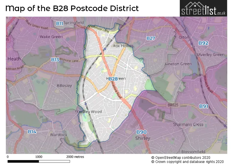
The B28 Postcode shares a border with B11 (BIRMINGHAM, Sparkhill, Tyseley), B13 (BIRMINGHAM, Moseley), B14 (BIRMINGHAM, Kings Heath, Yardley Wood), B90 (Shirley, Cheswick Green, Tidbury Green) and B27 (BIRMINGHAM, Acocks Green).
The primary settlement in the B28 postcode district is Hall Green, which is located in the county of West Midlands, England. Other significant settlements include Birmingham, also located in the county of West Midlands. The most significant post town in the B28 postcode district is Birmingham.
For the district B28, we have data on 4 postcode sectors. Here's a breakdown: The sector B28 0, covers Birmingham and Hall Green in West Midlands. The sector B28 1 is non-geographic. It's often designated for PO Boxes, large organisations, or special services. The sector B28 8, covers Birmingham and Hall Green in West Midlands. The sector B28 9, covers Birmingham and Hall Green in West Midlands.

Map of the B28 Postcode District
Explore the B28 postcode district by using our free interactive map.
When it comes to local government, postal geography often disregards political borders. However, for a breakdown in the B28 District: the district mostly encompasses the Birmingham District (B) (596 postcodes), and finally, the Solihull District (B) area (8 postcodes).
Weather Forecast for B28
Press Button to Show Forecast for Hall Green
| Time Period | Icon | Description | Temperature | Rain Probability | Wind |
|---|---|---|---|---|---|
| 09:00 to 12:00 | Light rain | 7.0°C (feels like 4.0°C) | 75.00% | ENE 9 mph | |
| 12:00 to 15:00 | Overcast | 7.0°C (feels like 4.0°C) | 53.00% | NE 11 mph | |
| 15:00 to 18:00 | Overcast | 8.0°C (feels like 5.0°C) | 14.00% | NE 11 mph | |
| 18:00 to 21:00 | Overcast | 7.0°C (feels like 4.0°C) | 16.00% | NE 11 mph | |
| 21:00 to 00:00 | Overcast | 6.0°C (feels like 3.0°C) | 12.00% | NE 11 mph |
Press Button to Show Forecast for Hall Green
| Time Period | Icon | Description | Temperature | Rain Probability | Wind |
|---|---|---|---|---|---|
| 00:00 to 03:00 | Overcast | 6.0°C (feels like 2.0°C) | 15.00% | NNE 11 mph | |
| 03:00 to 06:00 | Overcast | 5.0°C (feels like 2.0°C) | 19.00% | NNE 11 mph | |
| 06:00 to 09:00 | Light rain | 5.0°C (feels like 2.0°C) | 55.00% | N 11 mph | |
| 09:00 to 12:00 | Heavy rain | 6.0°C (feels like 3.0°C) | 73.00% | NNW 11 mph | |
| 12:00 to 15:00 | Light rain | 8.0°C (feels like 6.0°C) | 51.00% | NW 9 mph | |
| 15:00 to 18:00 | Cloudy | 10.0°C (feels like 7.0°C) | 16.00% | WNW 9 mph | |
| 18:00 to 21:00 | Cloudy | 9.0°C (feels like 7.0°C) | 10.00% | WSW 7 mph | |
| 21:00 to 00:00 | Clear night | 7.0°C (feels like 5.0°C) | 3.00% | SW 7 mph |
Press Button to Show Forecast for Hall Green
| Time Period | Icon | Description | Temperature | Rain Probability | Wind |
|---|---|---|---|---|---|
| 00:00 to 03:00 | Clear night | 5.0°C (feels like 3.0°C) | 1.00% | SW 7 mph | |
| 03:00 to 06:00 | Clear night | 4.0°C (feels like 1.0°C) | 2.00% | SSW 7 mph | |
| 06:00 to 09:00 | Sunny day | 5.0°C (feels like 2.0°C) | 2.00% | S 7 mph | |
| 09:00 to 12:00 | Partly cloudy (day) | 10.0°C (feels like 7.0°C) | 2.00% | S 11 mph | |
| 12:00 to 15:00 | Overcast | 12.0°C (feels like 9.0°C) | 10.00% | S 13 mph | |
| 15:00 to 18:00 | Cloudy | 13.0°C (feels like 10.0°C) | 7.00% | S 13 mph | |
| 18:00 to 21:00 | Partly cloudy (day) | 12.0°C (feels like 10.0°C) | 4.00% | S 11 mph | |
| 21:00 to 00:00 | Clear night | 9.0°C (feels like 7.0°C) | 3.00% | SSE 9 mph |
Press Button to Show Forecast for Hall Green
| Time Period | Icon | Description | Temperature | Rain Probability | Wind |
|---|---|---|---|---|---|
| 00:00 to 03:00 | Clear night | 8.0°C (feels like 5.0°C) | 3.00% | SSE 9 mph | |
| 03:00 to 06:00 | Clear night | 7.0°C (feels like 4.0°C) | 2.00% | SE 9 mph | |
| 06:00 to 09:00 | Sunny day | 7.0°C (feels like 5.0°C) | 4.00% | SE 9 mph | |
| 09:00 to 12:00 | Sunny day | 12.0°C (feels like 10.0°C) | 6.00% | SE 11 mph | |
| 12:00 to 15:00 | Partly cloudy (day) | 15.0°C (feels like 12.0°C) | 11.00% | SE 13 mph | |
| 15:00 to 18:00 | Cloudy | 15.0°C (feels like 13.0°C) | 14.00% | SE 11 mph | |
| 18:00 to 21:00 | Light rain shower (day) | 14.0°C (feels like 12.0°C) | 30.00% | SE 9 mph | |
| 21:00 to 00:00 | Cloudy | 11.0°C (feels like 10.0°C) | 12.00% | ESE 7 mph |
Where is the B28 Postcode District?
The postcode district B28 is located in Birmingham, a city in the United Kingdom. It is nearby several towns, including Solihull to the East, Smethwick to the North West, Henley-in-Arden to the South, Redditch to the South West, Halesowen to the West, and Sutton Coldfield to the North. The distance from B28 to the center of London is approximately 96.99 miles.
The district is within the post town of BIRMINGHAM.
The sector has postcodes within the nation of England.
The B28 Postcode District is covers the following regions.
- Birmingham - West Midlands - West Midlands (England)
- Solihull - West Midlands - West Midlands (England)
| Postcode Sector | Delivery Office |
|---|---|
| B28 0 | Hall Green Delivery Office |
| B28 8 | Hall Green Delivery Office |
| B28 9 | Hall Green Delivery Office |
| B | 2 | 8 | - | X | X | X |
| B | 2 | 8 | Space | Numeric | Letter | Letter |
Current Monthly Rental Prices
| # Bedrooms | Min Price | Max Price | Avg Price |
|---|---|---|---|
| 1 | £100 | £825 | £590 |
| 2 | £900 | £900 | £900 |
| 3 | £975 | £1,450 | £1,231 |
| 4 | £1,550 | £1,900 | £1,725 |
| 5 | £1,850 | £1,850 | £1,850 |
Current House Prices
| # Bedrooms | Min Price | Max Price | Avg Price |
|---|---|---|---|
| 3 | £415,000 | £450,000 | £435,722 |
| 4 | £425,000 | £580,000 | £474,500 |
| 5 | £450,000 | £563,500 | £495,899 |
| 7 | £725,000 | £725,000 | £725,000 |
Estate Agents who Operate in the B28 District
| Logo | Name | Brand Name | Address | Contact Number | Total Properties |
|---|---|---|---|---|---|
 | Shirley | Smart Homes Ltd | 316 Stratford Road Shirley Solihull B90 3DN | 01202 145410 | 23 |
 | Shirley | Burchell Edwards | 183 Stratford Road, Shirley, Solihull, B90 3AU | 0121 387 6554 | 11 |
 | Shirley | Shipways | 208 Stratford Road, Shirley, Solihull, B90 3AG | 0121 387 6304 | 10 |
 | Hall Green | Manny Klarico | 176 Highfield Road, Hall Green, Birmingham, B28 0HT | 0121 387 6544 | 10 |
 | Hall Green | Clive Tanner Wyatts | Highfield House 1562-1564 Stratford Road Hall Green Solihull B28 9HA | 0121 387 6379 | 6 |
| Type of Property | 2018 Average | 2018 Sales | 2017 Average | 2017 Sales | 2016 Average | 2016 Sales | 2015 Average | 2015 Sales |
|---|---|---|---|---|---|---|---|---|
| Detached | £301,853 | 29 | £279,026 | 41 | £283,100 | 59 | £255,351 | 55 |
| Semi-Detached | £253,724 | 205 | £241,661 | 175 | £218,490 | 235 | £201,562 | 225 |
| Terraced | £225,454 | 118 | £199,025 | 145 | £183,700 | 142 | £175,990 | 145 |
| Flats | £111,609 | 40 | £117,387 | 51 | £126,330 | 47 | £96,842 | 43 |