The B90 postcode district is a postal district located in the B Birmingham postcode area with a population of 49,616 residents according to the 2021 England and Wales Census.
The area of the B90 postcode district is 8.59 square miles which is 22.24 square kilometres or 5,494.79 acres.
Currently, the B90 district has about 1057 postcode units spread across 5 geographic postcode sectors.
Given that each sector allows for 400 unique postcode combinations, the district has a capacity of 2,000 postcodes. With 1057 postcodes already in use, this leaves 943 units available.
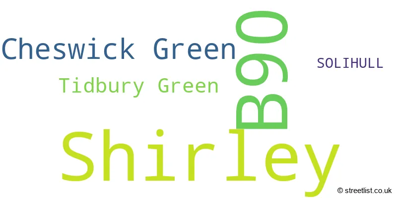
The largest settlement in the B90 postal code is Shirley followed by Cheswick Green, and Tidbury Green.
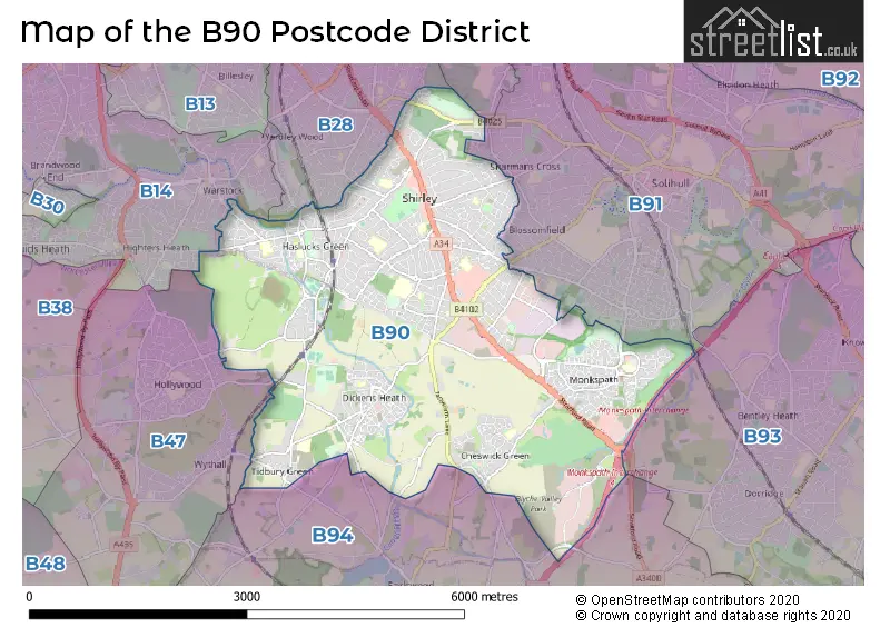
The B90 Postcode shares a border with B28 (BIRMINGHAM, Hall Green), B91 (SOLIHULL, Catherine-de-Barnes), B93 (Knowle, Dorridge, Bentley Heath), B94 (Hockley Heath, Lapworth, Earlswood), B14 (BIRMINGHAM, Kings Heath, Yardley Wood) and B47 (Hollywood, Wythall).
The primary settlement in the B90 postcode district is Shirley, located in the county of West Midlands, England. The post town for this district is SOLIHULL. There are also other significant settlements in this district, including Tidbury Green and Cheswick Green.
For the district B90, we have data on 6 postcode sectors. Here's a breakdown: The sector B90 1, covers Shirley in West Midlands. The sector B90 1, covers Shirley in Worcestershire. The sector B90 2, covers Shirley in West Midlands. The sector B90 3, covers Shirley in West Midlands. The sector B90 4, covers Shirley and Cheswick Green in West Midlands. The sector B90 8, covers Shirley in West Midlands. The sector B90 9 is non-geographic. It's often designated for PO Boxes, large organisations, or special services.

Map of the B90 Postcode District
Explore the B90 postcode district by using our free interactive map.
When it comes to local government, postal geography often disregards political borders. However, for a breakdown in the B90 District: the district mostly encompasses the Solihull District (B) (1048 postcodes), and finally, the Bromsgrove District area (37 postcodes).
Weather Forecast for B90
Press Button to Show Forecast for Shirley Heath
| Time Period | Icon | Description | Temperature | Rain Probability | Wind |
|---|---|---|---|---|---|
| 09:00 to 12:00 | Heavy rain | 7.0°C (feels like 3.0°C) | 75.00% | ENE 11 mph | |
| 12:00 to 15:00 | Overcast | 7.0°C (feels like 4.0°C) | 52.00% | NE 11 mph | |
| 15:00 to 18:00 | Overcast | 8.0°C (feels like 5.0°C) | 14.00% | NE 11 mph | |
| 18:00 to 21:00 | Overcast | 7.0°C (feels like 4.0°C) | 17.00% | NE 11 mph | |
| 21:00 to 00:00 | Overcast | 6.0°C (feels like 3.0°C) | 12.00% | NE 11 mph |
Press Button to Show Forecast for Shirley Heath
| Time Period | Icon | Description | Temperature | Rain Probability | Wind |
|---|---|---|---|---|---|
| 00:00 to 03:00 | Overcast | 6.0°C (feels like 2.0°C) | 16.00% | NNE 11 mph | |
| 03:00 to 06:00 | Overcast | 5.0°C (feels like 2.0°C) | 27.00% | NNE 11 mph | |
| 06:00 to 09:00 | Light rain | 5.0°C (feels like 2.0°C) | 55.00% | N 11 mph | |
| 09:00 to 12:00 | Heavy rain | 6.0°C (feels like 3.0°C) | 73.00% | NNW 11 mph | |
| 12:00 to 15:00 | Light rain | 8.0°C (feels like 5.0°C) | 51.00% | NW 9 mph | |
| 15:00 to 18:00 | Cloudy | 9.0°C (feels like 7.0°C) | 16.00% | WNW 9 mph | |
| 18:00 to 21:00 | Cloudy | 9.0°C (feels like 7.0°C) | 10.00% | WSW 7 mph | |
| 21:00 to 00:00 | Clear night | 7.0°C (feels like 5.0°C) | 3.00% | SW 7 mph |
Press Button to Show Forecast for Shirley Heath
| Time Period | Icon | Description | Temperature | Rain Probability | Wind |
|---|---|---|---|---|---|
| 00:00 to 03:00 | Clear night | 5.0°C (feels like 3.0°C) | 1.00% | SW 7 mph | |
| 03:00 to 06:00 | Clear night | 4.0°C (feels like 1.0°C) | 2.00% | SSW 7 mph | |
| 06:00 to 09:00 | Sunny day | 5.0°C (feels like 2.0°C) | 2.00% | S 7 mph | |
| 09:00 to 12:00 | Partly cloudy (day) | 10.0°C (feels like 7.0°C) | 2.00% | S 11 mph | |
| 12:00 to 15:00 | Overcast | 12.0°C (feels like 9.0°C) | 10.00% | S 13 mph | |
| 15:00 to 18:00 | Cloudy | 13.0°C (feels like 10.0°C) | 7.00% | S 13 mph | |
| 18:00 to 21:00 | Partly cloudy (day) | 12.0°C (feels like 10.0°C) | 4.00% | S 11 mph | |
| 21:00 to 00:00 | Clear night | 9.0°C (feels like 7.0°C) | 3.00% | SSE 9 mph |
Press Button to Show Forecast for Shirley Heath
| Time Period | Icon | Description | Temperature | Rain Probability | Wind |
|---|---|---|---|---|---|
| 00:00 to 03:00 | Clear night | 8.0°C (feels like 5.0°C) | 3.00% | SSE 9 mph | |
| 03:00 to 06:00 | Clear night | 7.0°C (feels like 4.0°C) | 2.00% | SE 9 mph | |
| 06:00 to 09:00 | Sunny day | 7.0°C (feels like 5.0°C) | 4.00% | SE 9 mph | |
| 09:00 to 12:00 | Sunny day | 12.0°C (feels like 10.0°C) | 6.00% | SE 11 mph | |
| 12:00 to 15:00 | Partly cloudy (day) | 15.0°C (feels like 12.0°C) | 11.00% | SE 13 mph | |
| 15:00 to 18:00 | Cloudy | 15.0°C (feels like 13.0°C) | 14.00% | SE 11 mph | |
| 18:00 to 21:00 | Light rain shower (day) | 14.0°C (feels like 12.0°C) | 30.00% | SE 9 mph | |
| 21:00 to 00:00 | Cloudy | 11.0°C (feels like 10.0°C) | 12.00% | ESE 7 mph |
Where is the B90 Postcode District?
The data suggests that the postcode district B90 belongs to Solihull, which is a town located in West Midlands. Solihull is in close proximity to Birmingham, which is about 5.6 miles to the northwest. Additionally, Henley-In-Arden is situated to the south, approximately 6.7 miles away. Redditch is located to the southwest at a distance of about 7.5 miles, while Kenilworth is to the east, approximately 10.3 miles away. Halesowen is another nearby town, situated to the west, around 10.4 miles away. It is important to note that Solihull is approximately 94.9 miles away from the center of London.
The district is within the post town of SOLIHULL.
The sector has postcodes within the nation of England.
The B90 Postcode District is covers the following regions.
- Solihull - West Midlands - West Midlands (England)
- Worcestershire - Herefordshire, Worcestershire and Warwickshire - West Midlands (England)
| Postcode Sector | Delivery Office |
|---|---|
| B90 1 | Shirley (b) Delivery Office |
| B90 2 | Shirley (b) Delivery Office |
| B90 3 | Shirley (b) Delivery Office |
| B90 4 | Shirley (b) Delivery Office |
| B90 8 | Shirley (b) Delivery Office |
| B | 9 | 0 | - | X | X | X |
| B | 9 | 0 | Space | Numeric | Letter | Letter |
Current Monthly Rental Prices
| # Bedrooms | Min Price | Max Price | Avg Price |
|---|---|---|---|
| 2 | £1,050 | £1,900 | £1,279 |
| 3 | £1,100 | £1,800 | £1,466 |
| 4 | £1,250 | £2,150 | £1,830 |
| 5 | £2,500 | £2,500 | £2,500 |
Current House Prices
| # Bedrooms | Min Price | Max Price | Avg Price |
|---|---|---|---|
| 3 | £849,950 | £849,950 | £849,950 |
| 4 | £652,950 | £975,000 | £760,654 |
| 5 | £675,000 | £1,375,000 | £872,273 |
| 6 | £850,000 | £850,000 | £850,000 |
Estate Agents who Operate in the B90 District
| Logo | Name | Brand Name | Address | Contact Number | Total Properties |
|---|---|---|---|---|---|
 | Shirley | Smart Homes Ltd | 316 Stratford Road Shirley Solihull B90 3DN | 01202 145410 | 69 |
 | Shirley | Melvyn Danes | 385 Stratford Road Shirley Solihull West Midlands B90 3BW | 0121 387 6404 | 46 |
 | Solihull | Black & Golds Estate Agents | 117 Stratford Road Shirley Solihull B90 3ND | 0121 387 6686 | 28 |
 | Solihull | Arden Estates | 450 Stratford Road, Shirley, Solihull, B90 4AQ | 0121 387 6622 | 19 |
 | Shirley | Horton & Storey | 179 Stratford Road, Shirley, Solihull, B90 3AU | 0121 663 0099 | 18 |
| Type of Property | 2018 Average | 2018 Sales | 2017 Average | 2017 Sales | 2016 Average | 2016 Sales | 2015 Average | 2015 Sales |
|---|---|---|---|---|---|---|---|---|
| Detached | £462,695 | 234 | £427,572 | 254 | £404,268 | 259 | £368,290 | 231 |
| Semi-Detached | £298,885 | 363 | £282,078 | 350 | £261,805 | 376 | £244,060 | 367 |
| Terraced | £270,271 | 151 | £265,798 | 166 | £240,617 | 174 | £205,099 | 194 |
| Flats | £188,785 | 281 | £174,227 | 278 | £154,199 | 206 | £152,648 | 199 |