The B91 postcode district is a postal district located in the B Birmingham postcode area with a population of 33,843 residents according to the 2021 England and Wales Census.
The area of the B91 postcode district is 6.70 square miles which is 17.35 square kilometres or 4,287.64 acres.
Currently, the B91 district has about 853 postcode units spread across 3 geographic postcode sectors.
Given that each sector allows for 400 unique postcode combinations, the district has a capacity of 1,200 postcodes. With 853 postcodes already in use, this leaves 347 units available.
The largest settlements in the B91 postal code are SOLIHULL and Catherine-de-Barnes.
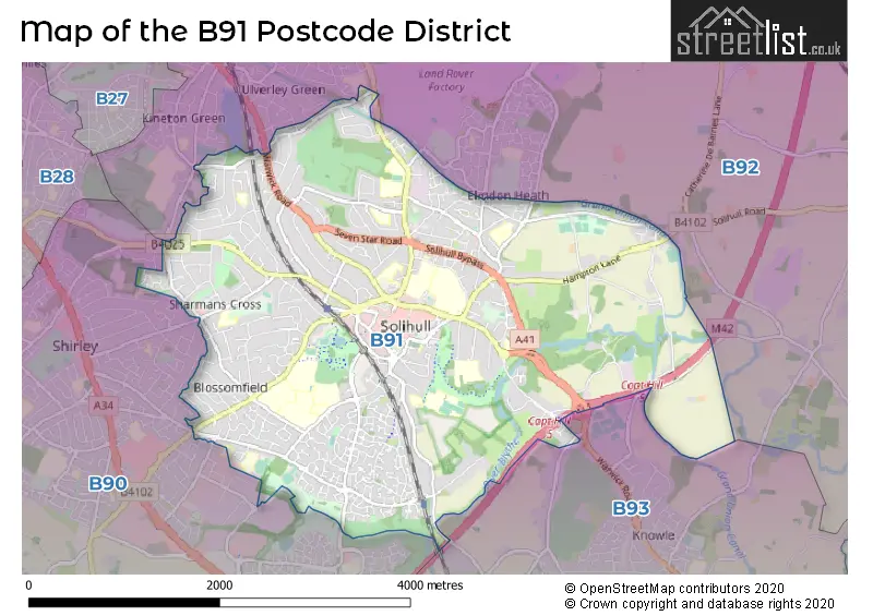
The B91 Postcode shares a border with B92 (SOLIHULL, Hampton-in-Arden, Barston), B93 (Knowle, Dorridge, Bentley Heath) and B90 (Shirley, Cheswick Green, Tidbury Green).
The primary settlement in the B91 postcode district is Solihull, located in the West Midlands. Solihull has the highest count of postcodes within this district. Additionally, there is another significant settlement called Catherine-de-Barnes, also located in Solihull. The county in which these settlements are located is the West Midlands county. The most significant post town in the B91 postcode district is Solihull.
For the district B91, we have data on 4 postcode sectors. Here's a breakdown: The sector B91 1, covers Solihull in West Midlands. The sector B91 2, covers Solihull in West Midlands. The sector B91 3, covers Solihull in West Midlands. The sector B91 9 is non-geographic. It's often designated for PO Boxes, large organisations, or special services.

Map of the B91 Postcode District
Explore the B91 postcode district by using our free interactive map.
When it comes to local government, postal geography often disregards political borders. However, for a breakdown in the B91 District: the district mostly encompasses the Solihull District (B) area with a total of 852 postcodes.
Weather Forecast for B91
Press Button to Show Forecast for Solihull
| Time Period | Icon | Description | Temperature | Rain Probability | Wind |
|---|---|---|---|---|---|
| 09:00 to 12:00 | Heavy rain | 7.0°C (feels like 4.0°C) | 74.00% | ENE 9 mph | |
| 12:00 to 15:00 | Overcast | 7.0°C (feels like 4.0°C) | 50.00% | NE 11 mph | |
| 15:00 to 18:00 | Overcast | 8.0°C (feels like 5.0°C) | 16.00% | NE 11 mph | |
| 18:00 to 21:00 | Overcast | 7.0°C (feels like 4.0°C) | 14.00% | NE 11 mph | |
| 21:00 to 00:00 | Overcast | 6.0°C (feels like 3.0°C) | 12.00% | NE 11 mph |
Press Button to Show Forecast for Solihull
| Time Period | Icon | Description | Temperature | Rain Probability | Wind |
|---|---|---|---|---|---|
| 00:00 to 03:00 | Overcast | 6.0°C (feels like 2.0°C) | 18.00% | NNE 11 mph | |
| 03:00 to 06:00 | Overcast | 5.0°C (feels like 2.0°C) | 20.00% | NNE 11 mph | |
| 06:00 to 09:00 | Light rain | 5.0°C (feels like 2.0°C) | 52.00% | N 11 mph | |
| 09:00 to 12:00 | Heavy rain | 6.0°C (feels like 3.0°C) | 74.00% | NNW 11 mph | |
| 12:00 to 15:00 | Light rain | 8.0°C (feels like 6.0°C) | 51.00% | NW 9 mph | |
| 15:00 to 18:00 | Cloudy | 10.0°C (feels like 7.0°C) | 16.00% | WNW 9 mph | |
| 18:00 to 21:00 | Cloudy | 9.0°C (feels like 8.0°C) | 10.00% | WSW 7 mph | |
| 21:00 to 00:00 | Clear night | 7.0°C (feels like 5.0°C) | 3.00% | SW 7 mph |
Press Button to Show Forecast for Solihull
| Time Period | Icon | Description | Temperature | Rain Probability | Wind |
|---|---|---|---|---|---|
| 00:00 to 03:00 | Clear night | 5.0°C (feels like 3.0°C) | 1.00% | SW 7 mph | |
| 03:00 to 06:00 | Clear night | 4.0°C (feels like 1.0°C) | 2.00% | SSW 7 mph | |
| 06:00 to 09:00 | Sunny day | 5.0°C (feels like 2.0°C) | 2.00% | S 7 mph | |
| 09:00 to 12:00 | Partly cloudy (day) | 10.0°C (feels like 7.0°C) | 2.00% | S 11 mph | |
| 12:00 to 15:00 | Overcast | 12.0°C (feels like 10.0°C) | 10.00% | S 13 mph | |
| 15:00 to 18:00 | Cloudy | 13.0°C (feels like 10.0°C) | 7.00% | S 13 mph | |
| 18:00 to 21:00 | Partly cloudy (day) | 12.0°C (feels like 10.0°C) | 4.00% | S 11 mph | |
| 21:00 to 00:00 | Clear night | 9.0°C (feels like 7.0°C) | 3.00% | SSE 9 mph |
Press Button to Show Forecast for Solihull
| Time Period | Icon | Description | Temperature | Rain Probability | Wind |
|---|---|---|---|---|---|
| 00:00 to 03:00 | Clear night | 8.0°C (feels like 5.0°C) | 3.00% | SSE 9 mph | |
| 03:00 to 06:00 | Clear night | 7.0°C (feels like 4.0°C) | 2.00% | SE 9 mph | |
| 06:00 to 09:00 | Sunny day | 7.0°C (feels like 5.0°C) | 4.00% | SE 9 mph | |
| 09:00 to 12:00 | Sunny day | 12.0°C (feels like 10.0°C) | 6.00% | SE 11 mph | |
| 12:00 to 15:00 | Partly cloudy (day) | 15.0°C (feels like 12.0°C) | 11.00% | SE 13 mph | |
| 15:00 to 18:00 | Cloudy | 15.0°C (feels like 13.0°C) | 14.00% | SE 11 mph | |
| 18:00 to 21:00 | Light rain shower (day) | 14.0°C (feels like 12.0°C) | 30.00% | SE 9 mph | |
| 21:00 to 00:00 | Cloudy | 11.0°C (feels like 10.0°C) | 12.00% | ESE 7 mph |
Where is the B91 Postcode District?
The postcode district for B91 is in Solihull. Solihull is near several towns, including Birmingham to the northwest (5.91 miles away), Henley-in-Arden to the south (7.80 miles away), Kenilworth to the southeast (8.79 miles away), Redditch to the southwest (9.92 miles away), Sutton Coldfield to the north (11.05 miles away), and Coventry to the east (11.34 miles away). Additionally, this district is approximately 94.17 miles away from the center of London.
The district is within the post town of SOLIHULL.
The sector has postcodes within the nation of England.
The B91 Postcode District is in the Solihull region of West Midlands within the West Midlands (England).
| Postcode Sector | Delivery Office |
|---|---|
| B91 1 | Solihull Delivery Office |
| B91 2 | Solihull Delivery Office |
| B91 3 | Solihull Delivery Office |
| B | 9 | 1 | - | X | X | X |
| B | 9 | 1 | Space | Numeric | Letter | Letter |
Current Monthly Rental Prices
| # Bedrooms | Min Price | Max Price | Avg Price |
|---|---|---|---|
| 2 | £1,800 | £2,429 | £2,250 |
| 3 | £1,600 | £2,400 | £1,816 |
| 4 | £2,000 | £4,900 | £2,849 |
| 5 | £2,600 | £2,995 | £2,815 |
| 6 | £2,300 | £3,600 | £3,133 |
| 10 | £8,000 | £8,000 | £8,000 |
Current House Prices
| # Bedrooms | Min Price | Max Price | Avg Price |
|---|---|---|---|
| 4 | £989,000 | £1,350,000 | £1,105,667 |
| 5 | £1,000,000 | £1,950,000 | £1,411,154 |
| 6 | £1,350,000 | £2,500,000 | £1,890,000 |
| 10 | £2,700,000 | £2,700,000 | £2,700,000 |
Estate Agents who Operate in the B91 District
| Logo | Name | Brand Name | Address | Contact Number | Total Properties |
|---|---|---|---|---|---|
 | Solihull | Xact Homes | 6 The Square Solihull B91 3RB | 0121 387 6415 | 49 |
 | Solihull | Ruxton Independent Estate Agents & Valuers | 6 The Square, Solihull, B91 3RB | 0121 387 6388 | 29 |
 | Shirley | Smart Homes Ltd | 316 Stratford Road Shirley Solihull B90 3DN | 01202 145410 | 28 |
 | Solihull | DM & Co. Homes | 8 The Pavillions, Cranmore Drive, Solihull, B90 4SB | 0121 387 6730 | 19 |
 | Solihull | John Shepherd | 6-8, Drury Lane Solihull B91 3BD | 01202 145364 | 14 |
| Type of Property | 2018 Average | 2018 Sales | 2017 Average | 2017 Sales | 2016 Average | 2016 Sales | 2015 Average | 2015 Sales |
|---|---|---|---|---|---|---|---|---|
| Detached | £622,501 | 219 | £600,903 | 207 | £546,285 | 245 | £520,669 | 266 |
| Semi-Detached | £372,543 | 110 | £349,007 | 143 | £341,193 | 122 | £314,643 | 137 |
| Terraced | £295,813 | 35 | £287,376 | 53 | £249,647 | 55 | £252,819 | 55 |
| Flats | £238,959 | 221 | £231,056 | 207 | £204,787 | 171 | £215,767 | 198 |