The B92 postcode district is a postal district located in the B Birmingham postcode area with a population of 37,070 residents according to the 2021 England and Wales Census.
The area of the B92 postcode district is 14.19 square miles which is 36.76 square kilometres or 9,082.73 acres.
Currently, the B92 district has about 723 postcode units spread across 4 geographic postcode sectors.
Given that each sector allows for 400 unique postcode combinations, the district has a capacity of 1,600 postcodes. With 723 postcodes already in use, this leaves 877 units available.
The largest settlement in the B92 postal code is SOLIHULL followed by Hampton-in-Arden, and Barston.
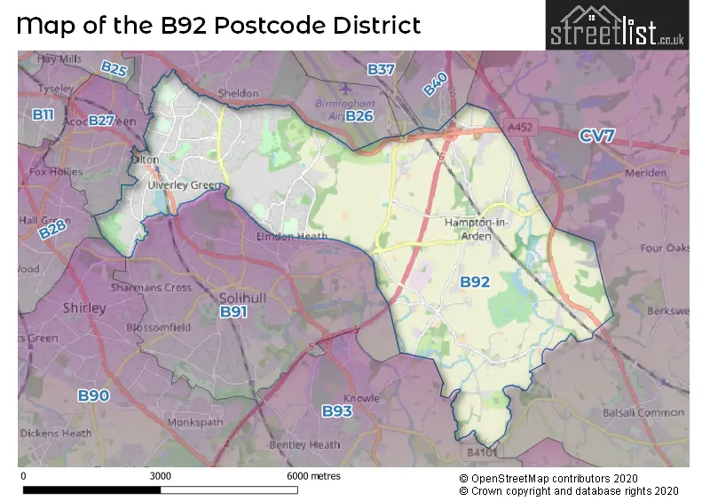
The B92 Postcode shares a border with B37 (BIRMINGHAM, Marston Green, Birmingham Business Park), B91 (SOLIHULL, Catherine-de-Barnes), B93 (Knowle, Dorridge, Bentley Heath), B26 (BIRMINGHAM, Sheldon, Yardley), B40 (BIRMINGHAM), CV7 (Balsall Common, Exhall, Meriden) and B27 (BIRMINGHAM, Acocks Green).
The primary settlement in the B92 postcode district is Solihull, located in the West Midlands. Other significant settlements in this district include Barston, Bickenhill, Bradnocks Marsh, Catherine-de-Barnes, and Hampton-in-Arden. The primary post town is Solihull, which is also in the West Midlands county.
For the district B92, we have data on 4 postcode sectors. Here's a breakdown: The sector B92 0, covers Hampton-In-Arden and Solihull and Barston in West Midlands. The sector B92 7, covers Solihull in West Midlands. The sector B92 8, covers Solihull in West Midlands. The sector B92 9, covers Solihull in West Midlands.


Map of the B92 Postcode District
Explore the B92 postcode district by using our free interactive map.
When it comes to local government, postal geography often disregards political borders. However, for a breakdown in the B92 District: the district mostly encompasses the Solihull District (B) area with a total of 725 postcodes.
Weather Forecast for B92
Press Button to Show Forecast for Elmdon Heath
| Time Period | Icon | Description | Temperature | Rain Probability | Wind |
|---|---|---|---|---|---|
| 09:00 to 12:00 | Heavy rain | 7.0°C (feels like 4.0°C) | 74.00% | ENE 9 mph | |
| 12:00 to 15:00 | Overcast | 7.0°C (feels like 4.0°C) | 50.00% | NE 11 mph | |
| 15:00 to 18:00 | Overcast | 8.0°C (feels like 5.0°C) | 16.00% | NE 11 mph | |
| 18:00 to 21:00 | Overcast | 7.0°C (feels like 4.0°C) | 14.00% | NE 11 mph | |
| 21:00 to 00:00 | Overcast | 6.0°C (feels like 3.0°C) | 12.00% | NE 11 mph |
Press Button to Show Forecast for Elmdon Heath
| Time Period | Icon | Description | Temperature | Rain Probability | Wind |
|---|---|---|---|---|---|
| 00:00 to 03:00 | Overcast | 6.0°C (feels like 2.0°C) | 18.00% | NNE 11 mph | |
| 03:00 to 06:00 | Overcast | 5.0°C (feels like 2.0°C) | 20.00% | NNE 11 mph | |
| 06:00 to 09:00 | Light rain | 5.0°C (feels like 2.0°C) | 52.00% | N 11 mph | |
| 09:00 to 12:00 | Heavy rain | 6.0°C (feels like 3.0°C) | 74.00% | NNW 11 mph | |
| 12:00 to 15:00 | Light rain | 8.0°C (feels like 6.0°C) | 51.00% | NW 9 mph | |
| 15:00 to 18:00 | Cloudy | 10.0°C (feels like 7.0°C) | 16.00% | WNW 9 mph | |
| 18:00 to 21:00 | Cloudy | 9.0°C (feels like 8.0°C) | 10.00% | WSW 7 mph | |
| 21:00 to 00:00 | Clear night | 7.0°C (feels like 5.0°C) | 3.00% | SW 7 mph |
Press Button to Show Forecast for Elmdon Heath
| Time Period | Icon | Description | Temperature | Rain Probability | Wind |
|---|---|---|---|---|---|
| 00:00 to 03:00 | Clear night | 5.0°C (feels like 3.0°C) | 1.00% | SW 7 mph | |
| 03:00 to 06:00 | Clear night | 4.0°C (feels like 2.0°C) | 2.00% | SSW 7 mph | |
| 06:00 to 09:00 | Sunny day | 5.0°C (feels like 2.0°C) | 2.00% | S 7 mph | |
| 09:00 to 12:00 | Partly cloudy (day) | 10.0°C (feels like 8.0°C) | 2.00% | S 11 mph | |
| 12:00 to 15:00 | Overcast | 12.0°C (feels like 10.0°C) | 10.00% | S 13 mph | |
| 15:00 to 18:00 | Cloudy | 13.0°C (feels like 10.0°C) | 7.00% | S 13 mph | |
| 18:00 to 21:00 | Partly cloudy (day) | 12.0°C (feels like 10.0°C) | 4.00% | S 11 mph | |
| 21:00 to 00:00 | Clear night | 9.0°C (feels like 7.0°C) | 3.00% | SSE 9 mph |
Press Button to Show Forecast for Elmdon Heath
| Time Period | Icon | Description | Temperature | Rain Probability | Wind |
|---|---|---|---|---|---|
| 00:00 to 03:00 | Clear night | 8.0°C (feels like 5.0°C) | 3.00% | SSE 9 mph | |
| 03:00 to 06:00 | Clear night | 7.0°C (feels like 4.0°C) | 2.00% | SE 9 mph | |
| 06:00 to 09:00 | Sunny day | 7.0°C (feels like 5.0°C) | 4.00% | SE 9 mph | |
| 09:00 to 12:00 | Sunny day | 12.0°C (feels like 10.0°C) | 6.00% | SE 11 mph | |
| 12:00 to 15:00 | Partly cloudy (day) | 15.0°C (feels like 12.0°C) | 11.00% | SE 13 mph | |
| 15:00 to 18:00 | Cloudy | 15.0°C (feels like 13.0°C) | 14.00% | SE 11 mph | |
| 18:00 to 21:00 | Light rain shower (day) | 14.0°C (feels like 12.0°C) | 30.00% | SE 9 mph | |
| 21:00 to 00:00 | Cloudy | 12.0°C (feels like 10.0°C) | 12.00% | ESE 7 mph |
Where is the B92 Postcode District?
The postcode district B92 is located in Solihull, a town in the West Midlands region of England. Solihull is situated near several nearby towns: Birmingham to the North West (approximately 7.12 miles away), Kenilworth to the South East (approximately 7.63 miles away), Henley-in-Arden to the South (approximately 9.03 miles away), Coventry to the East (approximately 9.4 miles away), Redditch to the South West (approximately 11.93 miles away), and Atherstone to the North East (approximately 12.01 miles away). Additionally, the distance from Solihull to the center of London is approximately 93.31 miles.
The district is within the post town of SOLIHULL.
The sector has postcodes within the nation of England.
The B92 Postcode District is in the Solihull region of West Midlands within the West Midlands (England).
| Postcode Sector | Delivery Office |
|---|---|
| B92 7 | Solihull Delivery Office |
| B92 8 | Solihull Delivery Office |
| B92 9 | Solihull Delivery Office |
| B | 9 | 2 | - | X | X | X |
| B | 9 | 2 | Space | Numeric | Letter | Letter |
Current Monthly Rental Prices
| # Bedrooms | Min Price | Max Price | Avg Price |
|---|---|---|---|
| 1 | £575 | £900 | £741 |
| 2 | £815 | £4,500 | £1,607 |
| 3 | £1,195 | £2,000 | £1,431 |
| 4 | £1,695 | £3,750 | £2,548 |
| 5 | £480 | £4,495 | £2,908 |
Current House Prices
| # Bedrooms | Min Price | Max Price | Avg Price |
|---|---|---|---|
| £1,100,000 | £1,100,000 | £1,100,000 | |
| 3 | £300,000 | £1,100,000 | £700,000 |
| 4 | £700,000 | £1,100,000 | £885,714 |
| 5 | £725,000 | £2,250,000 | £1,107,000 |
| 6 | £750,000 | £2,795,000 | £1,515,000 |
| 7 | £1,500,000 | £2,500,000 | £2,000,000 |
| 8 | £1,300,000 | £1,300,000 | £1,300,000 |
Estate Agents who Operate in the B92 District
| Logo | Name | Brand Name | Address | Contact Number | Total Properties |
|---|---|---|---|---|---|
 | Shirley | Smart Homes Ltd | 316 Stratford Road Shirley Solihull B90 3DN | 01202 145410 | 25 |
 | Solihull | Burchell Edwards | Doubleday House High Street, Solihull, B91 3SN | 0121 387 6555 | 20 |
 | Sheldon | Sydney Mitchell Estate Agents | Shakespeare Building 2233 Coventry Road, Sheldon, Solihull, B26 3NL | 0121 387 6636 | 16 |
 | Solihull | Xact Homes | 6 The Square Solihull B91 3RB | 0121 387 6415 | 14 |
 | Solihull | Dixons | 70 Poplar Road, Solihull, West Midlands, B91 3AB | 0121 387 6292 | 14 |
| Type of Property | 2018 Average | 2018 Sales | 2017 Average | 2017 Sales | 2016 Average | 2016 Sales | 2015 Average | 2015 Sales |
|---|---|---|---|---|---|---|---|---|
| Detached | £486,955 | 82 | £541,619 | 90 | £454,974 | 110 | £388,021 | 90 |
| Semi-Detached | £270,884 | 335 | £261,748 | 329 | £248,410 | 329 | £220,663 | 285 |
| Terraced | £244,180 | 133 | £233,645 | 168 | £218,243 | 146 | £204,972 | 143 |
| Flats | £147,837 | 115 | £156,040 | 122 | £153,159 | 127 | £136,829 | 115 |