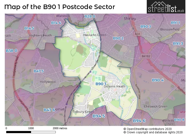
The B90 1 postcode sector stands on the West Midlands and Worcestershire border.
Did you know? According to the 2021 Census, the B90 1 postcode sector is home to a bustling 12,660 residents!
Given that each sector allows for 400 unique postcode combinations. Letters C, I, K, M, O and V are not allowed in the last two letters of a postcode. With 276 postcodes already in use, this leaves 124 units available.
The largest settlements in the B90 1 postal code are Shirley and Tidbury Green.
The B90 1 Postcode shares a border with B14 4 (BIRMINGHAM, Yardley Wood, Kings Heath), B28 0 (BIRMINGHAM, Hall Green), B47 5 (Hollywood), B94 5 (Earlswood, Tanworth-in-Arden, Lapworth), B47 6 (Wythall), B90 2 (Shirley), B90 4 (Shirley, Cheswick Green) and B94 6 (Hockley Heath, Lapworth, Earlswood).
The sector is within the post town of SOLIHULL.
B90 1 is a postcode sector within the B90 postcode district which is within the B Birmingham postcode area.
The Royal Mail delivery office for the B90 1 postal sector is the Shirley (b) Delivery Office.
The area of the B90 1 postcode sector is 3.09 square miles which is 8.00 square kilometres or 1,976.91 square acres.
Waterways within the B90 1 postcode sector include the Stratford-upon-Avon Canal, River Cole.

Map of the B90 1 Postcode Sector
Explore the B90 1 postcode sector by using our free interactive map.
| B | 9 | 0 | - | 1 | X | X |
| B | 9 | 0 | Space | 1 | Letter | Letter |
Official List of Streets
Tidbury Green (20 Streets)
Shirley (120 Streets)
Unofficial Streets or Alternative Spellings
Hall Green
PRIORY ROADBIRMINGHAM
MAYBERRY CLOSE MAYPOLE LANE PRINCE OF WALES LANEEarlswood
CLEOBURY LANE FULFORD HALL ROAD LADY LANE NORTON LANE RUMBUSH LANEHollywood
HOUNDSFIELD LANE RICHMOND CLOSE TRUEMANS HEATH LANEWeather Forecast for B90 1
Press Button to Show Forecast for Shirley Heath
| Time Period | Icon | Description | Temperature | Rain Probability | Wind |
|---|---|---|---|---|---|
| 09:00 to 12:00 | Heavy rain | 7.0°C (feels like 3.0°C) | 75.00% | ENE 11 mph | |
| 12:00 to 15:00 | Overcast | 7.0°C (feels like 4.0°C) | 52.00% | NE 11 mph | |
| 15:00 to 18:00 | Overcast | 8.0°C (feels like 5.0°C) | 14.00% | NE 11 mph | |
| 18:00 to 21:00 | Overcast | 7.0°C (feels like 4.0°C) | 17.00% | NE 11 mph | |
| 21:00 to 00:00 | Overcast | 6.0°C (feels like 3.0°C) | 12.00% | NE 11 mph |
Press Button to Show Forecast for Shirley Heath
| Time Period | Icon | Description | Temperature | Rain Probability | Wind |
|---|---|---|---|---|---|
| 00:00 to 03:00 | Overcast | 6.0°C (feels like 2.0°C) | 16.00% | NNE 11 mph | |
| 03:00 to 06:00 | Overcast | 5.0°C (feels like 2.0°C) | 27.00% | NNE 11 mph | |
| 06:00 to 09:00 | Light rain | 5.0°C (feels like 2.0°C) | 55.00% | N 11 mph | |
| 09:00 to 12:00 | Heavy rain | 6.0°C (feels like 3.0°C) | 73.00% | NNW 11 mph | |
| 12:00 to 15:00 | Light rain | 8.0°C (feels like 5.0°C) | 51.00% | NW 9 mph | |
| 15:00 to 18:00 | Cloudy | 9.0°C (feels like 7.0°C) | 16.00% | WNW 9 mph | |
| 18:00 to 21:00 | Cloudy | 9.0°C (feels like 7.0°C) | 10.00% | WSW 7 mph | |
| 21:00 to 00:00 | Clear night | 7.0°C (feels like 5.0°C) | 3.00% | SW 7 mph |
Press Button to Show Forecast for Shirley Heath
| Time Period | Icon | Description | Temperature | Rain Probability | Wind |
|---|---|---|---|---|---|
| 00:00 to 03:00 | Clear night | 5.0°C (feels like 3.0°C) | 1.00% | SW 7 mph | |
| 03:00 to 06:00 | Clear night | 4.0°C (feels like 1.0°C) | 2.00% | SSW 7 mph | |
| 06:00 to 09:00 | Sunny day | 5.0°C (feels like 2.0°C) | 2.00% | S 7 mph | |
| 09:00 to 12:00 | Partly cloudy (day) | 10.0°C (feels like 7.0°C) | 2.00% | S 11 mph | |
| 12:00 to 15:00 | Overcast | 12.0°C (feels like 9.0°C) | 10.00% | S 13 mph | |
| 15:00 to 18:00 | Cloudy | 13.0°C (feels like 10.0°C) | 7.00% | S 13 mph | |
| 18:00 to 21:00 | Partly cloudy (day) | 12.0°C (feels like 10.0°C) | 4.00% | S 11 mph | |
| 21:00 to 00:00 | Clear night | 9.0°C (feels like 7.0°C) | 3.00% | SSE 9 mph |
Press Button to Show Forecast for Shirley Heath
| Time Period | Icon | Description | Temperature | Rain Probability | Wind |
|---|---|---|---|---|---|
| 00:00 to 03:00 | Clear night | 8.0°C (feels like 5.0°C) | 3.00% | SSE 9 mph | |
| 03:00 to 06:00 | Clear night | 7.0°C (feels like 4.0°C) | 2.00% | SE 9 mph | |
| 06:00 to 09:00 | Sunny day | 7.0°C (feels like 5.0°C) | 4.00% | SE 9 mph | |
| 09:00 to 12:00 | Sunny day | 12.0°C (feels like 10.0°C) | 6.00% | SE 11 mph | |
| 12:00 to 15:00 | Partly cloudy (day) | 15.0°C (feels like 12.0°C) | 11.00% | SE 13 mph | |
| 15:00 to 18:00 | Cloudy | 15.0°C (feels like 13.0°C) | 14.00% | SE 11 mph | |
| 18:00 to 21:00 | Light rain shower (day) | 14.0°C (feels like 12.0°C) | 30.00% | SE 9 mph | |
| 21:00 to 00:00 | Cloudy | 11.0°C (feels like 10.0°C) | 12.00% | ESE 7 mph |
Schools and Places of Education Within the B90 1 Postcode Sector
Dickens Heath Community Primary School
Community school
Three Acres Lane, Solihull, West Midlands, B90 1NA
Head: Mrs J Nicholls
Ofsted Rating: Good
Inspection: 2022-04-06 (752 days ago)
Website: Visit Dickens Heath Community Primary School Website
Phone: 01217338359
Number of Pupils: 464
Mill Lodge Primary School
Community school
Aqueduct Road, Solihull, West Midlands, B90 1BT
Head: Mrs Joanne Challender
Ofsted Rating: Good
Inspection: 2023-09-20 (220 days ago)
Website: Visit Mill Lodge Primary School Website
Phone: 01214303010
Number of Pupils: 238
Peterbrook Primary School
Community school
High Street, Solihull, West Midlands, B90 1HR
Head: Mrs Lindsey Thorne
Ofsted Rating: Requires improvement
Inspection: 2022-02-09 (808 days ago)
Website: Visit Peterbrook Primary School Website
Phone: 01214302545
Number of Pupils: 432
Tidbury Green School
Community school
Dickens Heath Road, Solihull, West Midlands, B90 1QW
Head: Mrs Rosalind Fitter
Ofsted Rating: Good
Inspection: 2023-03-09 (415 days ago)
Website: Visit Tidbury Green School Website
Phone: 01564823189
Number of Pupils: 478
House Prices in the B90 1 Postcode Sector
| Type of Property | 2018 Average | 2018 Sales | 2017 Average | 2017 Sales | 2016 Average | 2016 Sales | 2015 Average | 2015 Sales |
|---|---|---|---|---|---|---|---|---|
| Detached | £526,324 | 72 | £476,036 | 77 | £430,672 | 121 | £382,974 | 100 |
| Semi-Detached | £279,405 | 69 | £276,842 | 76 | £247,239 | 105 | £236,835 | 82 |
| Terraced | £289,942 | 49 | £272,343 | 30 | £244,922 | 55 | £185,604 | 65 |
| Flats | £190,297 | 159 | £176,282 | 175 | £155,980 | 145 | £163,958 | 101 |
Important Postcodes B90 1 in the Postcode Sector
B90 1AE is the postcode for Green Lane Nursery, Green Lane, Coronation Youth Centre, Green Lane, and Coronation Youth Centre, Green Lane, Shirley
B90 1BT is the postcode for Mill Lodge Primary School, Aqueduct Road, Shirley, and Mill Lodge Primary School, Aqueduct Road
B90 1HR is the postcode for INFANT SCHOOL, Peterbrook Junior & Infant School, High Street, JUNIOR SCHOOL, Peterbrook Junior & Infant School, High Street, and Peterbrook Junior & Infant School, High Street
B90 1JP is the postcode for Sunhaven EPH & Day Centre, 210 High Street
B90 1JT is the postcode for Coombes House, 1360 Yardley Wood Road
B90 1NA is the postcode for Dickens Heath Primary School, Three Acres Lane, Shirley, and Dickens Heath Primary School, Three Acres Lane
B90 1QW is the postcode for Tidbury Green School, Dickens Heath Road, Tidbury Green, and Tidbury Green School, Dickens Heath Road
| The B90 1 Sector is within these Local Authorities |
|
|---|---|
| The B90 1 Sector is within these Counties |
|
| The B90 1 Sector is within these Water Company Areas |
|