The B47 postcode district is a postal district located in the B Birmingham postcode area with a population of 10,163 residents according to the 2021 England and Wales Census.
The area of the B47 postcode district is 3.68 square miles which is 9.52 square kilometres or 2,352.25 acres.
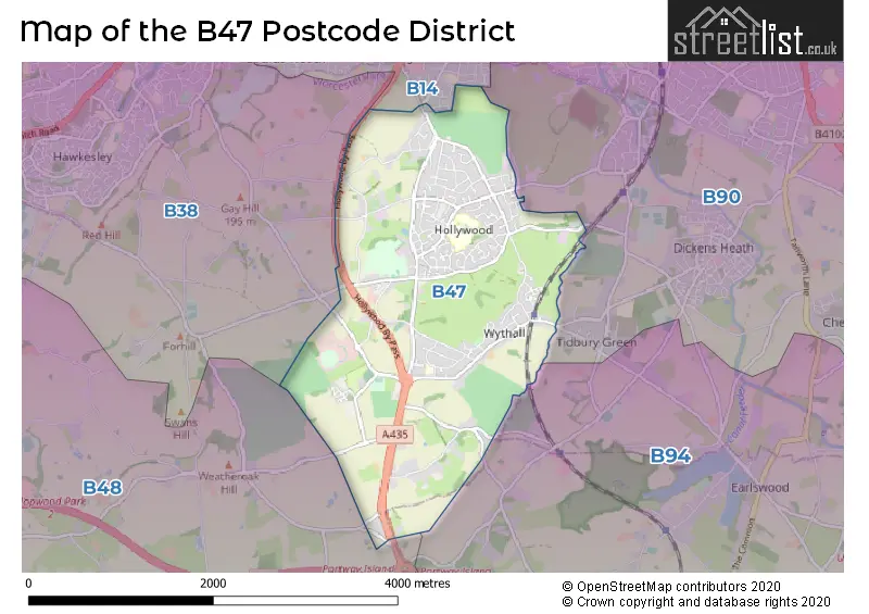
Currently, the B47 district has about 241 postcode units spread across 2 geographic postcode sectors.
Given that each sector allows for 400 unique postcode combinations, the district has a capacity of 800 postcodes. With 241 postcodes already in use, this leaves 559 units available.
The largest settlements in the B47 postal code are Hollywood and Wythall.
The B47 Postcode shares a border with B94 (Hockley Heath, Lapworth, Earlswood), B14 (BIRMINGHAM, Kings Heath, Yardley Wood) and B90 (Shirley, Cheswick Green, Tidbury Green).
The primary settlement in the B47 postcode district is Hollywood, located in Birmingham, West Midlands. Other significant settlements include Wythall, also in Birmingham, with additional parts in Warwickshire and Worcestershire. The most significant post town in this district is Birmingham, which encompasses both Hollywood and Wythall.
For the district B47, we have data on 2 postcode sectors. Here's a breakdown: The sector B47 5, covers Hollywood in Worcestershire. The sector B47 6, covers Wythall in Worcestershire.


Map of the B47 Postcode District
Explore the B47 postcode district by using our free interactive map.
When it comes to local government, postal geography often disregards political borders. However, for a breakdown in the B47 District: the district mostly encompasses the Bromsgrove District (236 postcodes), and finally, the Birmingham District (B) area (5 postcodes).
Weather Forecast for B47
Press Button to Show Forecast for Highter's Heath
| Time Period | Icon | Description | Temperature | Rain Probability | Wind |
|---|---|---|---|---|---|
| 09:00 to 12:00 | Light rain | 6.0°C (feels like 3.0°C) | 57.00% | ENE 11 mph | |
| 12:00 to 15:00 | Overcast | 7.0°C (feels like 4.0°C) | 53.00% | ENE 11 mph | |
| 15:00 to 18:00 | Overcast | 7.0°C (feels like 4.0°C) | 14.00% | NE 11 mph | |
| 18:00 to 21:00 | Overcast | 7.0°C (feels like 4.0°C) | 17.00% | NE 11 mph | |
| 21:00 to 00:00 | Overcast | 6.0°C (feels like 3.0°C) | 12.00% | NE 11 mph |
Press Button to Show Forecast for Highter's Heath
| Time Period | Icon | Description | Temperature | Rain Probability | Wind |
|---|---|---|---|---|---|
| 00:00 to 03:00 | Overcast | 5.0°C (feels like 2.0°C) | 15.00% | NNE 11 mph | |
| 03:00 to 06:00 | Overcast | 5.0°C (feels like 1.0°C) | 19.00% | NNE 11 mph | |
| 06:00 to 09:00 | Light rain | 5.0°C (feels like 1.0°C) | 55.00% | N 11 mph | |
| 09:00 to 12:00 | Heavy rain | 6.0°C (feels like 3.0°C) | 73.00% | NNW 11 mph | |
| 12:00 to 15:00 | Light rain | 8.0°C (feels like 5.0°C) | 50.00% | NW 11 mph | |
| 15:00 to 18:00 | Overcast | 9.0°C (feels like 7.0°C) | 18.00% | WNW 9 mph | |
| 18:00 to 21:00 | Cloudy | 9.0°C (feels like 7.0°C) | 10.00% | WSW 9 mph | |
| 21:00 to 00:00 | Clear night | 7.0°C (feels like 4.0°C) | 3.00% | SW 7 mph |
Press Button to Show Forecast for Highter's Heath
| Time Period | Icon | Description | Temperature | Rain Probability | Wind |
|---|---|---|---|---|---|
| 00:00 to 03:00 | Clear night | 5.0°C (feels like 2.0°C) | 1.00% | SW 7 mph | |
| 03:00 to 06:00 | Clear night | 4.0°C (feels like 1.0°C) | 2.00% | SSW 9 mph | |
| 06:00 to 09:00 | Sunny day | 5.0°C (feels like 2.0°C) | 2.00% | S 9 mph | |
| 09:00 to 12:00 | Partly cloudy (day) | 10.0°C (feels like 7.0°C) | 2.00% | S 13 mph | |
| 12:00 to 15:00 | Overcast | 12.0°C (feels like 9.0°C) | 10.00% | S 16 mph | |
| 15:00 to 18:00 | Cloudy | 13.0°C (feels like 10.0°C) | 7.00% | S 16 mph | |
| 18:00 to 21:00 | Partly cloudy (day) | 12.0°C (feels like 9.0°C) | 4.00% | S 13 mph | |
| 21:00 to 00:00 | Clear night | 9.0°C (feels like 6.0°C) | 3.00% | SSE 11 mph |
Press Button to Show Forecast for Highter's Heath
| Time Period | Icon | Description | Temperature | Rain Probability | Wind |
|---|---|---|---|---|---|
| 00:00 to 03:00 | Clear night | 8.0°C (feels like 4.0°C) | 3.00% | SSE 11 mph | |
| 03:00 to 06:00 | Clear night | 7.0°C (feels like 4.0°C) | 3.00% | SE 11 mph | |
| 06:00 to 09:00 | Sunny day | 7.0°C (feels like 4.0°C) | 4.00% | SE 11 mph | |
| 09:00 to 12:00 | Sunny day | 12.0°C (feels like 9.0°C) | 6.00% | SE 11 mph | |
| 12:00 to 15:00 | Partly cloudy (day) | 14.0°C (feels like 12.0°C) | 11.00% | SE 13 mph | |
| 15:00 to 18:00 | Cloudy | 15.0°C (feels like 12.0°C) | 15.00% | SE 13 mph | |
| 18:00 to 21:00 | Light rain shower (day) | 14.0°C (feels like 12.0°C) | 30.00% | SE 11 mph | |
| 21:00 to 00:00 | Cloudy | 11.0°C (feels like 9.0°C) | 12.00% | ESE 9 mph |
Where is the B47 Postcode District?
The B47 postcode district is located in Birmingham. It is in close proximity to several nearby towns. To the North East is Solihull, which is approximately 4.18 miles away. To the South West is Redditch, with a distance of approximately 5.49 miles. Henley-in-Arden is located to the South East, approximately 6.83 miles away. To the South is Studley, which is around 7.29 miles away. Lastly, Smethwick is situated to the North West, with a distance of approximately 8.46 miles. In addition, the B47 postcode district is about 96.22 miles away from the center of London.
The district is within the post town of BIRMINGHAM.
The sector has postcodes within the nation of England.
The B47 Postcode District is covers the following regions.
- Worcestershire - Herefordshire, Worcestershire and Warwickshire - West Midlands (England)
- Birmingham - West Midlands - West Midlands (England)
- Warwickshire - Herefordshire, Worcestershire and Warwickshire - West Midlands (England)
| Postcode Sector | Delivery Office |
|---|---|
| B47 5 | Moseley Delivery Office |
| B47 6 | Moseley Delivery Office |
| B | 4 | 7 | - | X | X | X |
| B | 4 | 7 | Space | Numeric | Letter | Letter |
Tourist Attractions within the Postcode Area
We found 1 visitor attractions within the B47 postcode area
| Earlswood Village Museum |
|---|
| Museums & Art Galleries |
| Museum and / or Art Gallery |
| View Earlswood Village Museum on Google Maps |
Current Monthly Rental Prices
| # Bedrooms | Min Price | Max Price | Avg Price |
|---|---|---|---|
| 4 | £2,250 | £2,250 | £2,250 |
Current House Prices
| # Bedrooms | Min Price | Max Price | Avg Price |
|---|---|---|---|
| 2 | £525,000 | £525,000 | £525,000 |
| 3 | £465,000 | £700,000 | £540,714 |
| 4 | £465,000 | £960,000 | £603,923 |
| 5 | £650,000 | £980,000 | £832,500 |
Estate Agents who Operate in the B47 District
| Logo | Name | Brand Name | Address | Contact Number | Total Properties |
|---|---|---|---|---|---|
 | Hollywood | Drakes Estate Agents | 3 Drakes Cross Parade, Hollywood, Birmingham, B47 5HD | 01564 335142 | 9 |
 | Wythall | Melvyn Danes | 321 Alcester Road, Wythall, Birmingham, B47 5HJ | 01564 331054 | 9 |
 | Solihull | Black & Golds Estate Agents | 117 Stratford Road Shirley Solihull B90 3ND | 0121 387 6686 | 4 |
 | Solihull | Arden Estates | 450 Stratford Road, Shirley, Solihull, B90 4AQ | 0121 387 6622 | 4 |
 | Nationwide | Visum | Web based Estate Agent | 03300 101115 | 3 |
| Type of Property | 2018 Average | 2018 Sales | 2017 Average | 2017 Sales | 2016 Average | 2016 Sales | 2015 Average | 2015 Sales |
|---|---|---|---|---|---|---|---|---|
| Detached | £420,513 | 69 | £408,769 | 70 | £366,410 | 92 | £348,195 | 63 |
| Semi-Detached | £304,105 | 77 | £265,556 | 62 | £247,536 | 55 | £247,816 | 54 |
| Terraced | £225,797 | 35 | £255,520 | 30 | £228,862 | 38 | £218,081 | 32 |
| Flats | £153,250 | 6 | £150,333 | 12 | £156,369 | 8 | £108,658 | 6 |