The B90 4 postcode sector is within the county of West Midlands.
Did you know? According to the 2021 Census, the B90 4 postcode sector is home to a bustling 12,700 residents!
Given that each sector allows for 400 unique postcode combinations. Letters C, I, K, M, O and V are not allowed in the last two letters of a postcode. With 304 postcodes already in use, this leaves 96 units available.
The largest settlements in the B90 4 postal code are Shirley and Cheswick Green.
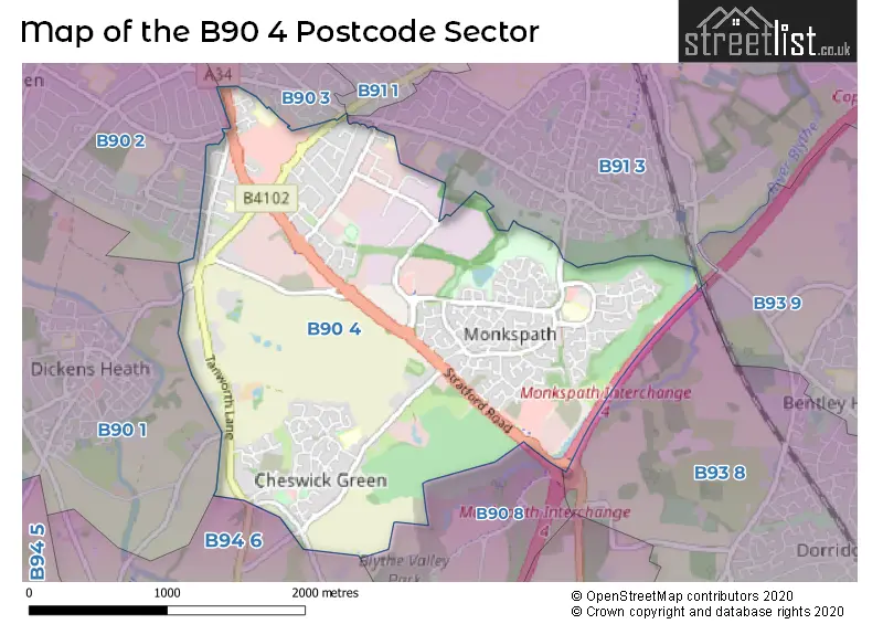
The B90 4 Postcode shares a border with B90 1 (Shirley, Tidbury Green), B90 8 (Shirley), B91 1 (SOLIHULL), B93 8 (Dorridge, Bentley Heath, Knowle), B90 2 (Shirley), B90 3 (Shirley), B91 3 (SOLIHULL), B93 9 (Knowle, Bentley Heath) and B94 6 (Hockley Heath, Lapworth, Earlswood).
The sector is within the post town of SOLIHULL.
B90 4 is a postcode sector within the B90 postcode district which is within the B Birmingham postcode area.
The Royal Mail delivery office for the B90 4 postal sector is the Shirley (b) Delivery Office.
The area of the B90 4 postcode sector is 2.83 square miles which is 7.33 square kilometres or 1,812.47 square acres.
The B90 4 postcode sector is crossed by the M42 motorway.
Waterways within the B90 4 postcode sector include the River Blythe.

Map of the B90 4 Postcode Sector
Explore the B90 4 postcode sector by using our free interactive map.
| B | 9 | 0 | - | 4 | X | X |
| B | 9 | 0 | Space | 4 | Letter | Letter |
Official List of Streets
Shirley (145 Streets)
Cheswick Green (40 Streets)
Unofficial Streets or Alternative Spellings
Shirley
DICKENS HEATH ROAD FALSTAFF ROAD MICKLEHILL DRIVE SHAKESPEARE DRIVE STRETTON ROAD WAKELIN ROAD WOODLANDS LANE WOODLOES ROAD CHALFORD WAY FARNBROUGH DRIVE HENLEYDALE HILLWOOD CLOSE LEESE CLOSE MONKSPATH MONKSPATH INTERCHANGE NOTCUTTS PATH SHEPHERDS GREEN LANE SNOWS HILL DRIVE WARWICK MEWSHockley Heath
ILLSHAW HEATH ROADHall Green
STRATFORD ROADEarlswood
LADY LANE VICARAGE ROAD WATERY LANEWeather Forecast for B90 4
Press Button to Show Forecast for Shirley Heath
| Time Period | Icon | Description | Temperature | Rain Probability | Wind |
|---|---|---|---|---|---|
| 09:00 to 12:00 | Heavy rain | 7.0°C (feels like 3.0°C) | 75.00% | ENE 11 mph | |
| 12:00 to 15:00 | Overcast | 7.0°C (feels like 4.0°C) | 52.00% | NE 11 mph | |
| 15:00 to 18:00 | Overcast | 8.0°C (feels like 5.0°C) | 14.00% | NE 11 mph | |
| 18:00 to 21:00 | Overcast | 7.0°C (feels like 4.0°C) | 17.00% | NE 11 mph | |
| 21:00 to 00:00 | Overcast | 6.0°C (feels like 3.0°C) | 12.00% | NE 11 mph |
Press Button to Show Forecast for Shirley Heath
| Time Period | Icon | Description | Temperature | Rain Probability | Wind |
|---|---|---|---|---|---|
| 00:00 to 03:00 | Overcast | 6.0°C (feels like 2.0°C) | 16.00% | NNE 11 mph | |
| 03:00 to 06:00 | Overcast | 5.0°C (feels like 2.0°C) | 27.00% | NNE 11 mph | |
| 06:00 to 09:00 | Light rain | 5.0°C (feels like 2.0°C) | 55.00% | N 11 mph | |
| 09:00 to 12:00 | Heavy rain | 6.0°C (feels like 3.0°C) | 73.00% | NNW 11 mph | |
| 12:00 to 15:00 | Light rain | 8.0°C (feels like 5.0°C) | 51.00% | NW 9 mph | |
| 15:00 to 18:00 | Cloudy | 9.0°C (feels like 7.0°C) | 16.00% | WNW 9 mph | |
| 18:00 to 21:00 | Cloudy | 9.0°C (feels like 7.0°C) | 10.00% | WSW 7 mph | |
| 21:00 to 00:00 | Clear night | 7.0°C (feels like 5.0°C) | 3.00% | SW 7 mph |
Press Button to Show Forecast for Shirley Heath
| Time Period | Icon | Description | Temperature | Rain Probability | Wind |
|---|---|---|---|---|---|
| 00:00 to 03:00 | Clear night | 5.0°C (feels like 3.0°C) | 1.00% | SW 7 mph | |
| 03:00 to 06:00 | Clear night | 4.0°C (feels like 1.0°C) | 2.00% | SSW 7 mph | |
| 06:00 to 09:00 | Sunny day | 5.0°C (feels like 2.0°C) | 2.00% | S 7 mph | |
| 09:00 to 12:00 | Partly cloudy (day) | 10.0°C (feels like 7.0°C) | 2.00% | S 11 mph | |
| 12:00 to 15:00 | Overcast | 12.0°C (feels like 9.0°C) | 10.00% | S 13 mph | |
| 15:00 to 18:00 | Cloudy | 13.0°C (feels like 10.0°C) | 7.00% | S 13 mph | |
| 18:00 to 21:00 | Partly cloudy (day) | 12.0°C (feels like 10.0°C) | 4.00% | S 11 mph | |
| 21:00 to 00:00 | Clear night | 9.0°C (feels like 7.0°C) | 3.00% | SSE 9 mph |
Press Button to Show Forecast for Shirley Heath
| Time Period | Icon | Description | Temperature | Rain Probability | Wind |
|---|---|---|---|---|---|
| 00:00 to 03:00 | Clear night | 8.0°C (feels like 5.0°C) | 3.00% | SSE 9 mph | |
| 03:00 to 06:00 | Clear night | 7.0°C (feels like 4.0°C) | 2.00% | SE 9 mph | |
| 06:00 to 09:00 | Sunny day | 7.0°C (feels like 5.0°C) | 4.00% | SE 9 mph | |
| 09:00 to 12:00 | Sunny day | 12.0°C (feels like 10.0°C) | 6.00% | SE 11 mph | |
| 12:00 to 15:00 | Partly cloudy (day) | 15.0°C (feels like 12.0°C) | 11.00% | SE 13 mph | |
| 15:00 to 18:00 | Cloudy | 15.0°C (feels like 13.0°C) | 14.00% | SE 11 mph | |
| 18:00 to 21:00 | Light rain shower (day) | 14.0°C (feels like 12.0°C) | 30.00% | SE 9 mph | |
| 21:00 to 00:00 | Cloudy | 11.0°C (feels like 10.0°C) | 12.00% | ESE 7 mph |
Schools and Places of Education Within the B90 4 Postcode Sector
Cheswick Green Primary School
Community school
Cheswick Way, Solihull, West Midlands, B90 4HG
Head: Miss Carol Mason
Ofsted Rating: Good
Inspection: 2023-05-24 (339 days ago)
Website: Visit Cheswick Green Primary School Website
Phone: 01564703336
Number of Pupils: 253
Cranmore Infant School
Community school
Northland Road, Solihull, West Midlands, B90 4SA
Head: Mrs Rebecca Ward
Ofsted Rating: Good
Inspection: 2022-03-10 (779 days ago)
Website: Visit Cranmore Infant School Website
Phone: 01217053443
Number of Pupils: 211
Monkspath Junior and Infant School
Community school
Farmhouse Way, Solihull, West Midlands, B90 4EH
Head: Mr Dan Wild
Ofsted Rating: Good
Inspection: 2021-10-13 (927 days ago)
Website: Visit Monkspath Junior and Infant School Website
Phone: 01217052686
Number of Pupils: 671
Solihull Alternative Provision Academy
Free schools alternative provision
Cranmore Avenue, Solihull, West Midlands, B90 4LE
Head: Mrs Kat Dockery
Ofsted Rating: Good
Inspection: 2022-09-15 (590 days ago)
Website: Visit Solihull Alternative Provision Academy Website
Phone: 01217095420
Number of Pupils: 72
The Island Project School
Other independent special school
Tanworth Lane, Solihull, , B90 4DX
Head: Mrs Sarah Diane Gallagher
Ofsted Rating: Good
Inspection: 2021-07-01 (1031 days ago)
Website: Visit The Island Project School Website
Phone: 01675442588
Number of Pupils: 17
House Prices in the B90 4 Postcode Sector
| Type of Property | 2018 Average | 2018 Sales | 2017 Average | 2017 Sales | 2016 Average | 2016 Sales | 2015 Average | 2015 Sales |
|---|---|---|---|---|---|---|---|---|
| Detached | £462,042 | 86 | £416,798 | 104 | £408,740 | 82 | £373,487 | 65 |
| Semi-Detached | £290,111 | 70 | £285,969 | 83 | £264,784 | 68 | £243,980 | 57 |
| Terraced | £259,753 | 37 | £250,822 | 55 | £223,933 | 46 | £206,329 | 43 |
| Flats | £161,787 | 23 | £178,208 | 42 | £176,718 | 22 | £125,212 | 29 |
Important Postcodes B90 4 in the Postcode Sector
B90 4AY is the postcode for Our Lady of The Wayside Catholic Primary School, Stratford Road
B90 4BN is the postcode for FIRST AND SECOND FLOORS, Audit Commission, 1 Friars Gate, 1011 Stratford Road
B90 4DD is the postcode for Sans Souci Training Centre, Tanworth Lane, and Sans Souci Training Centre, Tanworth Lane, Shirley
B90 4EH is the postcode for Monkspath Junior & Infant School, Farmhouse Way, and Monkspath Health Centre, 29 Farmhouse Way
B90 4HG is the postcode for Cheswick Green Primary School, Cheswick Way
B90 4SA is the postcode for Cranmore Infant School, Northland Road, Shirley, and Cranmore Infant School, Northland Road
B90 4SJ is the postcode for EI Group PLC, 3 Monkspath Hall Road
| The B90 4 Sector is within these Local Authorities |
|
|---|---|
| The B90 4 Sector is within these Counties |
|
| The B90 4 Sector is within these Water Company Areas |
|