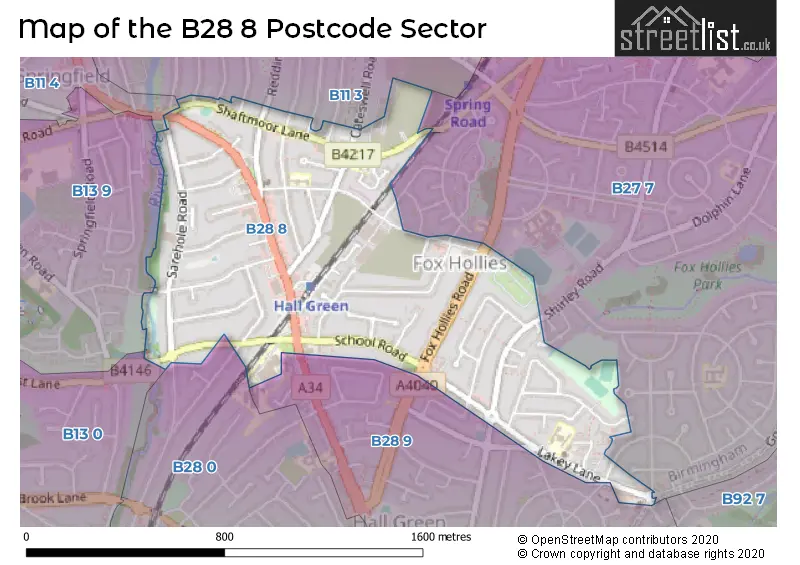
The B28 8 postcode sector is within the county of West Midlands.
Did you know? According to the 2021 Census, the B28 8 postcode sector is home to a bustling 9,447 residents!
Given that each sector allows for 400 unique postcode combinations. Letters C, I, K, M, O and V are not allowed in the last two letters of a postcode. With 168 postcodes already in use, this leaves 232 units available.
The largest settlements in the B28 8 postal code are BIRMINGHAM and Hall Green.
The B28 8 Postcode shares a border with B13 0 (BIRMINGHAM, Moseley), B28 0 (BIRMINGHAM, Hall Green), B28 9 (BIRMINGHAM, Hall Green), B11 3 (BIRMINGHAM, Sparkhill, Tyseley), B11 4 (Sparkhill, BIRMINGHAM), B13 9 (BIRMINGHAM, Moseley, Kings Heath) and B27 7 (BIRMINGHAM, Acocks Green).
The sector is within the post town of BIRMINGHAM.
B28 8 is a postcode sector within the B28 postcode district which is within the B Birmingham postcode area.
The Royal Mail delivery office for the B28 8 postal sector is the Hall Green Delivery Office.
The area of the B28 8 postcode sector is 0.61 square miles which is 1.57 square kilometres or 388.85 square acres.
Waterways within the B28 8 postcode sector include the River Cole.

Map of the B28 8 Postcode Sector
Explore the B28 8 postcode sector by using our free interactive map.
| B | 2 | 8 | - | 8 | X | X |
| B | 2 | 8 | Space | 8 | Letter | Letter |
Official List of Streets
BIRMINGHAM (41 Streets)
Hall Green (15 Streets)
Unofficial Streets or Alternative Spellings
BIRMINGHAM
ALLCROFT ROAD BROOM HALL CRESCENT CRESWELL ROAD GOSPEL FARM ROAD GOSPEL LANE GRIMSHAW ROAD HOLLYHOCK ROAD LEOMINSTER ROAD LYNCROFT ROAD MARIE DRIVE MIALL ROAD REDSTONE FARM ROAD RUNNYMEDE ROAD SLEAFORD ROAD SPRINGCROFT ROAD TETLEY ROAD THE LINKAcocks Green
FOX HOLLIES ROAD SHAFTMOOR LANE SHIRLEY ROAD BRINDLEY COURT RIVENDELL COURT SHAFTMOOR FARM LANE STATION DRIVEWeather Forecast for B28 8
Press Button to Show Forecast for Hall Green
| Time Period | Icon | Description | Temperature | Rain Probability | Wind |
|---|---|---|---|---|---|
| 09:00 to 12:00 | Light rain | 7.0°C (feels like 4.0°C) | 75.00% | ENE 9 mph | |
| 12:00 to 15:00 | Overcast | 7.0°C (feels like 4.0°C) | 53.00% | NE 11 mph | |
| 15:00 to 18:00 | Overcast | 8.0°C (feels like 5.0°C) | 14.00% | NE 11 mph | |
| 18:00 to 21:00 | Overcast | 7.0°C (feels like 4.0°C) | 16.00% | NE 11 mph | |
| 21:00 to 00:00 | Overcast | 6.0°C (feels like 3.0°C) | 12.00% | NE 11 mph |
Press Button to Show Forecast for Hall Green
| Time Period | Icon | Description | Temperature | Rain Probability | Wind |
|---|---|---|---|---|---|
| 00:00 to 03:00 | Overcast | 6.0°C (feels like 2.0°C) | 15.00% | NNE 11 mph | |
| 03:00 to 06:00 | Overcast | 5.0°C (feels like 2.0°C) | 19.00% | NNE 11 mph | |
| 06:00 to 09:00 | Light rain | 5.0°C (feels like 2.0°C) | 55.00% | N 11 mph | |
| 09:00 to 12:00 | Heavy rain | 6.0°C (feels like 3.0°C) | 73.00% | NNW 11 mph | |
| 12:00 to 15:00 | Light rain | 8.0°C (feels like 6.0°C) | 51.00% | NW 9 mph | |
| 15:00 to 18:00 | Cloudy | 10.0°C (feels like 7.0°C) | 16.00% | WNW 9 mph | |
| 18:00 to 21:00 | Cloudy | 9.0°C (feels like 7.0°C) | 10.00% | WSW 7 mph | |
| 21:00 to 00:00 | Clear night | 7.0°C (feels like 5.0°C) | 3.00% | SW 7 mph |
Press Button to Show Forecast for Hall Green
| Time Period | Icon | Description | Temperature | Rain Probability | Wind |
|---|---|---|---|---|---|
| 00:00 to 03:00 | Clear night | 5.0°C (feels like 3.0°C) | 1.00% | SW 7 mph | |
| 03:00 to 06:00 | Clear night | 4.0°C (feels like 1.0°C) | 2.00% | SSW 7 mph | |
| 06:00 to 09:00 | Sunny day | 5.0°C (feels like 2.0°C) | 2.00% | S 7 mph | |
| 09:00 to 12:00 | Partly cloudy (day) | 10.0°C (feels like 7.0°C) | 2.00% | S 11 mph | |
| 12:00 to 15:00 | Overcast | 12.0°C (feels like 9.0°C) | 10.00% | S 13 mph | |
| 15:00 to 18:00 | Cloudy | 13.0°C (feels like 10.0°C) | 7.00% | S 13 mph | |
| 18:00 to 21:00 | Partly cloudy (day) | 12.0°C (feels like 10.0°C) | 4.00% | S 11 mph | |
| 21:00 to 00:00 | Clear night | 9.0°C (feels like 7.0°C) | 3.00% | SSE 9 mph |
Press Button to Show Forecast for Hall Green
| Time Period | Icon | Description | Temperature | Rain Probability | Wind |
|---|---|---|---|---|---|
| 00:00 to 03:00 | Clear night | 8.0°C (feels like 5.0°C) | 3.00% | SSE 9 mph | |
| 03:00 to 06:00 | Clear night | 7.0°C (feels like 4.0°C) | 2.00% | SE 9 mph | |
| 06:00 to 09:00 | Sunny day | 7.0°C (feels like 5.0°C) | 4.00% | SE 9 mph | |
| 09:00 to 12:00 | Sunny day | 12.0°C (feels like 10.0°C) | 6.00% | SE 11 mph | |
| 12:00 to 15:00 | Partly cloudy (day) | 15.0°C (feels like 12.0°C) | 11.00% | SE 13 mph | |
| 15:00 to 18:00 | Cloudy | 15.0°C (feels like 13.0°C) | 14.00% | SE 11 mph | |
| 18:00 to 21:00 | Light rain shower (day) | 14.0°C (feels like 12.0°C) | 30.00% | SE 9 mph | |
| 21:00 to 00:00 | Cloudy | 11.0°C (feels like 10.0°C) | 12.00% | ESE 7 mph |
Schools and Places of Education Within the B28 8 Postcode Sector
Yorkmead Junior and Infant School
Community school
York Road, Birmingham, West Midlands, B28 8BB
Head: Mr Alex Newman-Smith
Ofsted Rating: Good
Inspection: 2023-07-14 (288 days ago)
Website: Visit Yorkmead Junior and Infant School Website
Phone: 01214644215
Number of Pupils: 462
House Prices in the B28 8 Postcode Sector
| Type of Property | 2018 Average | 2018 Sales | 2017 Average | 2017 Sales | 2016 Average | 2016 Sales | 2015 Average | 2015 Sales |
|---|---|---|---|---|---|---|---|---|
| Detached | £286,667 | 3 | £391,750 | 4 | £275,750 | 12 | £239,121 | 12 |
| Semi-Detached | £243,582 | 65 | £230,450 | 41 | £212,690 | 71 | £199,957 | 66 |
| Terraced | £211,175 | 28 | £175,613 | 41 | £178,053 | 49 | £169,132 | 40 |
| Flats | £89,845 | 10 | £126,420 | 14 | £138,883 | 13 | £82,222 | 9 |
Important Postcodes B28 8 in the Postcode Sector
B28 8BB is the postcode for Yorkmead Junior & Infant School, York Road, Hall Green, BIRMINGHAM CITY COUNCIL, Yorkmead Junior & Infant School, York Road, and Yorkmead Junior & Infant School, York Road
B28 8BG is the postcode for HALL GREEN HEALTH CENTRE, 977-979 STRATFORD ROAD, HALL GREEN, and Hall Green Health Centre, 977-979 Stratford Road
B28 8ES is the postcode for South Birmingham College, Cole Bank Road, and South Birmingham College, Cole Bank Road, Hall Green
B28 8PN is the postcode for Bushmere House, 137 Edenbridge Road
B28 8RY is the postcode for Lakey Lane Primary School, 210 Lakey Lane
| The B28 8 Sector is within these Local Authorities |
|
|---|---|
| The B28 8 Sector is within these Counties |
|
| The B28 8 Sector is within these Water Company Areas |
|