The B28 9 postcode sector is within the county of West Midlands.
Did you know? According to the 2021 Census, the B28 9 postcode sector is home to a bustling 8,135 residents!
Given that each sector allows for 400 unique postcode combinations. Letters C, I, K, M, O and V are not allowed in the last two letters of a postcode. With 148 postcodes already in use, this leaves 252 units available.
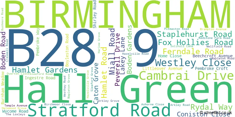
The largest settlements in the B28 9 postal code are BIRMINGHAM and Hall Green.
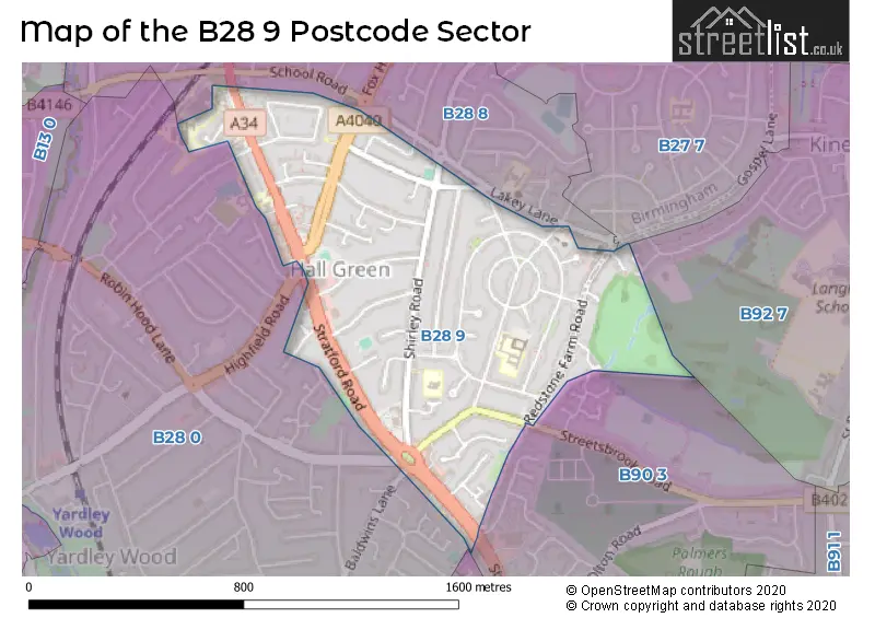
The B28 9 Postcode shares a border with B28 0 (BIRMINGHAM, Hall Green), B92 7 (SOLIHULL), B27 7 (BIRMINGHAM, Acocks Green), B28 8 (BIRMINGHAM, Hall Green), B90 2 (Shirley) and B90 3 (Shirley).
The sector is within the post town of BIRMINGHAM.
B28 9 is a postcode sector within the B28 postcode district which is within the B Birmingham postcode area.
The Royal Mail delivery office for the B28 9 postal sector is the Hall Green Delivery Office.
The area of the B28 9 postcode sector is 0.54 square miles which is 1.39 square kilometres or 342.79 square acres.

Map of the B28 9 Postcode Sector
Explore the B28 9 postcode sector by using our free interactive map.
| B | 2 | 8 | - | 9 | X | X |
| B | 2 | 8 | Space | 9 | Letter | Letter |
Official List of Streets
BIRMINGHAM (46 Streets)
Hall Green (3 Streets)
Unofficial Streets or Alternative Spellings
BIRMINGHAM
BALDWINS LANE GOSPEL LANE PETERSFIELD ROAD ROBIN HOOD LANEShirley
STREETSBROOK ROAD THE BRIDLE PATHAcocks Green
FOX HOLLIES ROAD SHIRLEY ROADSOLIHULL
HORNBROOK GROVEHall Green
HIGHFIELD ROAD CONISTON COSE GREEN COURT OAKTREE COURT PEVERILL DRIVE ROBIN HOOD ISLAND THE FAIRWAY THE LINKSWeather Forecast for B28 9
Press Button to Show Forecast for Hall Green
| Time Period | Icon | Description | Temperature | Rain Probability | Wind |
|---|---|---|---|---|---|
| 09:00 to 12:00 | Light rain | 7.0°C (feels like 4.0°C) | 75.00% | ENE 9 mph | |
| 12:00 to 15:00 | Overcast | 7.0°C (feels like 4.0°C) | 53.00% | NE 11 mph | |
| 15:00 to 18:00 | Overcast | 8.0°C (feels like 5.0°C) | 14.00% | NE 11 mph | |
| 18:00 to 21:00 | Overcast | 7.0°C (feels like 4.0°C) | 16.00% | NE 11 mph | |
| 21:00 to 00:00 | Overcast | 6.0°C (feels like 3.0°C) | 12.00% | NE 11 mph |
Press Button to Show Forecast for Hall Green
| Time Period | Icon | Description | Temperature | Rain Probability | Wind |
|---|---|---|---|---|---|
| 00:00 to 03:00 | Overcast | 6.0°C (feels like 2.0°C) | 15.00% | NNE 11 mph | |
| 03:00 to 06:00 | Overcast | 5.0°C (feels like 2.0°C) | 19.00% | NNE 11 mph | |
| 06:00 to 09:00 | Light rain | 5.0°C (feels like 2.0°C) | 55.00% | N 11 mph | |
| 09:00 to 12:00 | Heavy rain | 6.0°C (feels like 3.0°C) | 73.00% | NNW 11 mph | |
| 12:00 to 15:00 | Light rain | 8.0°C (feels like 6.0°C) | 51.00% | NW 9 mph | |
| 15:00 to 18:00 | Cloudy | 10.0°C (feels like 7.0°C) | 16.00% | WNW 9 mph | |
| 18:00 to 21:00 | Cloudy | 9.0°C (feels like 7.0°C) | 10.00% | WSW 7 mph | |
| 21:00 to 00:00 | Clear night | 7.0°C (feels like 5.0°C) | 3.00% | SW 7 mph |
Press Button to Show Forecast for Hall Green
| Time Period | Icon | Description | Temperature | Rain Probability | Wind |
|---|---|---|---|---|---|
| 00:00 to 03:00 | Clear night | 5.0°C (feels like 3.0°C) | 1.00% | SW 7 mph | |
| 03:00 to 06:00 | Clear night | 4.0°C (feels like 1.0°C) | 2.00% | SSW 7 mph | |
| 06:00 to 09:00 | Sunny day | 5.0°C (feels like 2.0°C) | 2.00% | S 7 mph | |
| 09:00 to 12:00 | Partly cloudy (day) | 10.0°C (feels like 7.0°C) | 2.00% | S 11 mph | |
| 12:00 to 15:00 | Overcast | 12.0°C (feels like 9.0°C) | 10.00% | S 13 mph | |
| 15:00 to 18:00 | Cloudy | 13.0°C (feels like 10.0°C) | 7.00% | S 13 mph | |
| 18:00 to 21:00 | Partly cloudy (day) | 12.0°C (feels like 10.0°C) | 4.00% | S 11 mph | |
| 21:00 to 00:00 | Clear night | 9.0°C (feels like 7.0°C) | 3.00% | SSE 9 mph |
Press Button to Show Forecast for Hall Green
| Time Period | Icon | Description | Temperature | Rain Probability | Wind |
|---|---|---|---|---|---|
| 00:00 to 03:00 | Clear night | 8.0°C (feels like 5.0°C) | 3.00% | SSE 9 mph | |
| 03:00 to 06:00 | Clear night | 7.0°C (feels like 4.0°C) | 2.00% | SE 9 mph | |
| 06:00 to 09:00 | Sunny day | 7.0°C (feels like 5.0°C) | 4.00% | SE 9 mph | |
| 09:00 to 12:00 | Sunny day | 12.0°C (feels like 10.0°C) | 6.00% | SE 11 mph | |
| 12:00 to 15:00 | Partly cloudy (day) | 15.0°C (feels like 12.0°C) | 11.00% | SE 13 mph | |
| 15:00 to 18:00 | Cloudy | 15.0°C (feels like 13.0°C) | 14.00% | SE 11 mph | |
| 18:00 to 21:00 | Light rain shower (day) | 14.0°C (feels like 12.0°C) | 30.00% | SE 9 mph | |
| 21:00 to 00:00 | Cloudy | 11.0°C (feels like 10.0°C) | 12.00% | ESE 7 mph |
Schools and Places of Education Within the B28 9 Postcode Sector
Aspire Ap School
Other independent school
Hall Green Baptist Church, , , B28 9EJ
Head: Mrs Viviene Royal
Ofsted Rating: Good
Inspection: 2022-05-26 (702 days ago)
Website: Visit Aspire Ap School Website
Phone: 01212435054
Number of Pupils: 7
Hall Green Junior School
Community school
Stratford Road, Birmingham, West Midlands, B28 9AJ
Head: Miss Maxine Charles
Ofsted Rating: Good
Inspection: 2021-11-04 (905 days ago)
Website: Visit Hall Green Junior School Website
Phone: 01214643840
Number of Pupils: 479
Robin Hood Academy
Academy converter
Pitmaston Road, Birmingham, West Midlands, B28 9PP
Head: Mr Alexander Harris
Ofsted Rating: Good
Inspection: 2022-09-22 (583 days ago)
Website: Visit Robin Hood Academy Website
Phone: 01214642187
Number of Pupils: 610
St Ambrose Barlow Catholic Primary School
Voluntary aided school
841 Shirley Road, Birmingham, West Midlands, B28 9JJ
Head: Mr Jon Clinton
Ofsted Rating: Good
Inspection: 2022-10-19 (556 days ago)
Website: Visit St Ambrose Barlow Catholic Primary School Website
Phone: 01214642791
Number of Pupils: 207
House Prices in the B28 9 Postcode Sector
| Type of Property | 2018 Average | 2018 Sales | 2017 Average | 2017 Sales | 2016 Average | 2016 Sales | 2015 Average | 2015 Sales |
|---|---|---|---|---|---|---|---|---|
| Detached | £317,250 | 4 | £243,111 | 9 | £292,600 | 10 | £261,500 | 12 |
| Semi-Detached | £263,124 | 36 | £237,018 | 34 | £229,141 | 44 | £197,486 | 42 |
| Terraced | £204,315 | 36 | £184,634 | 41 | £162,814 | 38 | £159,809 | 38 |
| Flats | £134,044 | 9 | £115,201 | 18 | £131,133 | 15 | £95,775 | 18 |
Important Postcodes B28 9 in the Postcode Sector
B28 9AD is the postcode for Birmingham City Council, Hall Green Library, 1221 Stratford Road
B28 9AJ is the postcode for BIRMINGHAM CITY COUNCIL, Hall Green Junior School, 1273 Stratford Road, Hall Green Junior School, 1273 Stratford Road, and Hall Green Junior School, 1273 Stratford Road, Hall Green
B28 9HG is the postcode for Royal Mail, Hall Green Delivery Office, 1319 Stratford Road
B28 9JJ is the postcode for ST AMBROSE BARLOW JUNIOR AND INFANTS SCHOOL, SHIRLEY ROAD, HALL GREEN, and St. Ambrose Barlow Catholic Primary School, 841 Shirley Road
B28 9PP is the postcode for Robin Hood Academy, Pitmaston Road, and Robin Hood Primary School, Pitmaston Road
| The B28 9 Sector is within these Local Authorities |
|
|---|---|
| The B28 9 Sector is within these Counties |
|
| The B28 9 Sector is within these Water Company Areas |
|