The B17 0 postcode sector is within the county of West Midlands.
Did you know? According to the 2021 Census, the B17 0 postcode sector is home to a bustling 9,385 residents!
Given that each sector allows for 400 unique postcode combinations. Letters C, I, K, M, O and V are not allowed in the last two letters of a postcode. With 196 postcodes already in use, this leaves 204 units available.
The largest settlements in the B17 0 postal code are BIRMINGHAM and Harborne.
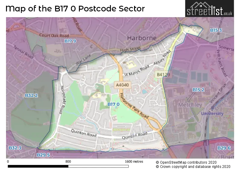
The B17 0 Postcode shares a border with B15 2 (BIRMINGHAM, Edgbaston), B15 3 (Edgbaston, BIRMINGHAM), B17 9 (BIRMINGHAM, Harborne), B29 5 (BIRMINGHAM), B29 6 (BIRMINGHAM, Selly Oak) and B32 2 (Quinton, BIRMINGHAM, Harborne).
The sector is within the post town of BIRMINGHAM.
B17 0 is a postcode sector within the B1 postcode district which is within the B Birmingham postcode area.
The Royal Mail delivery office for the B17 0 postal sector is the unknown.
The area of the B17 0 postcode sector is 0.77 square miles which is 2.00 square kilometres or 494.15 square acres.

Map of the B17 0 Postcode Sector
Explore the B17 0 postcode sector by using our free interactive map.
| B | 1 | 7 | - | 0 | X | X |
| B | 1 | 7 | Space | 0 | Letter | Letter |
Official List of Streets
Harborne (16 Streets)
BIRMINGHAM (67 Streets)
Unofficial Streets or Alternative Spellings
Edgbaston
METCHLEY LANE SOMERSET ROAD UNDERWOOD CLOSEBIRMINGHAM
FELLOWS LANE HARTS GREEN ROAD HINTLESHAM AVENUE LEASOW DRIVE STONEHOUSE HILL TENNAL ROAD WENTWORTH WAY ALMA PASSAGE BARLOWS ROAD BCS MAIN PATH BIRCH CLOSE BISHOPS CROFT BOURN BROOK WALKWAY CHAPEL PATH CHEYNE WALK CHURCH CROFT FAIRWAY MILLFARM ROAD OLD CHURCH AVENUE SAINT PETERS ROAD WINIFRIDE COURT YEWDALESchools and Places of Education Within the B17 0 Postcode Sector
St Mary's Catholic Primary School
Voluntary aided school
Vivian Road, Birmingham, West Midlands, B17 0DN
Head: Mrs Louise Yorke
Ofsted Rating: Good
Inspection: 2023-01-25 (484 days ago)
Website: Visit St Mary's Catholic Primary School Website
Phone: 01214642141
Number of Pupils: 418
St Peters CofE Primary School
Voluntary aided school
Old Church Road, Birmingham, West Midlands, B17 0BE
Head: Mrs Evelyn Murphy
Ofsted Rating: Good
Inspection: 2023-10-11 (225 days ago)
Website: Visit St Peters CofE Primary School Website
Phone: 01214642128
Number of Pupils: 446
House Prices in the B17 0 Postcode Sector
| Type of Property | 2018 Average | 2018 Sales | 2017 Average | 2017 Sales | 2016 Average | 2016 Sales | 2015 Average | 2015 Sales |
|---|---|---|---|---|---|---|---|---|
| Detached | £430,473 | 13 | £605,639 | 16 | £428,135 | 16 | £433,083 | 18 |
| Semi-Detached | £327,283 | 46 | £291,773 | 40 | £263,931 | 34 | £249,139 | 57 |
| Terraced | £277,502 | 63 | £259,704 | 76 | £229,376 | 75 | £239,293 | 95 |
| Flats | £156,352 | 31 | £167,826 | 27 | £147,265 | 40 | £131,570 | 27 |
Important Postcodes B17 0 in the Postcode Sector
B17 0AN is the postcode for 10, Albert Road, Harborne
B17 0BE is the postcode for KEY STAGE 2 BUILDING, Harborne Local Authority, St. Peter C of E School, Old Church Road, and KEY STAGE 1 BUILDING, Harborne Local Authority, St. Peter C of E School, Old Church Road
B17 0DN is the postcode for St. Marys Catholic Primary School, Vivian Road, and St. Marys RC School, Vivian Road
B17 0HG is the postcode for Harborne Medical Practice, 4 York Street, Harborne,
B17 0QX is the postcode for The Kenrick Centre, 2 Mill Farm Road
B17 0SN is the postcode for Harborne Church Farm Golf Course, Vicarage Road
| The B17 0 Sector is within these Local Authorities |
|
|---|---|
| The B17 0 Sector is within these Counties |
|
| The B17 0 Sector is within these Water Company Areas |
|