The B32 2 postcode sector is within the county of West Midlands.
Did you know? According to the 2021 Census, the B32 2 postcode sector is home to a bustling 13,621 residents!
Given that each sector allows for 400 unique postcode combinations. Letters C, I, K, M, O and V are not allowed in the last two letters of a postcode. With 216 postcodes already in use, this leaves 184 units available.
The largest settlement in the B32 2 postal code is Quinton followed by BIRMINGHAM, and Harborne.
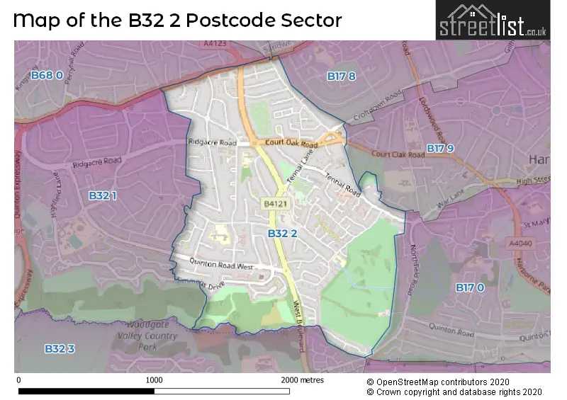
The B32 2 Postcode shares a border with B17 8 (BIRMINGHAM, Edgbaston, Harborne), B32 1 (Quinton, BIRMINGHAM), B68 0 (OLDBURY), B68 9 (OLDBURY), B17 9 (BIRMINGHAM, Harborne), B17 0 (BIRMINGHAM, Harborne), B29 5 (BIRMINGHAM), B32 3 (BIRMINGHAM, Quinton, Bartley Green) and B67 5 (SMETHWICK).
The sector is within the post town of BIRMINGHAM.
B32 2 is a postcode sector within the B32 postcode district which is within the B Birmingham postcode area.
The Royal Mail delivery office for the B32 2 postal sector is the Quinton Delivery Office.
The area of the B32 2 postcode sector is 1.02 square miles which is 2.63 square kilometres or 649.69 square acres.

Map of the B32 2 Postcode Sector
Explore the B32 2 postcode sector by using our free interactive map.
| B | 3 | 2 | - | 2 | X | X |
| B | 3 | 2 | Space | 2 | Letter | Letter |
Official List of Streets
Quinton (43 Streets)
Harborne (4 Streets)
BIRMINGHAM (53 Streets)
Unofficial Streets or Alternative Spellings
BIRMINGHAM
CROFTDOWN ROAD FITZ ROY AVENUE FREDAS GROVE HAMPTON COURT ROAD HARTS GREEN ROAD LELANT GROVE STONEHOUSE HILLHarborne
NORTHFIELD ROADQuinton
MAX ROAD MIDDLE LEASOW BOURN BROOK WALKWAY BOURNVALE WALK CALIFORNIA WAY ROSEMOUNT WORLDS END AVENUEOLDBURY
BIRCH LANE BIRCH ROAD GATELEY ROAD HARBORNE ROAD HAWTHORN CROFTWeather Forecast for B32 2
Press Button to Show Forecast for Harborne
| Time Period | Icon | Description | Temperature | Rain Probability | Wind |
|---|---|---|---|---|---|
| 09:00 to 12:00 | Heavy rain | 4.0°C (feels like 0.0°C) | 89.00% | NW 13 mph | |
| 12:00 to 15:00 | Heavy rain | 6.0°C (feels like 2.0°C) | 82.00% | WNW 13 mph | |
| 15:00 to 18:00 | Cloudy | 9.0°C (feels like 6.0°C) | 53.00% | WNW 11 mph | |
| 18:00 to 21:00 | Partly cloudy (day) | 9.0°C (feels like 7.0°C) | 7.00% | W 9 mph | |
| 21:00 to 00:00 | Clear night | 6.0°C (feels like 4.0°C) | 0.00% | SW 9 mph |
Press Button to Show Forecast for Harborne
| Time Period | Icon | Description | Temperature | Rain Probability | Wind |
|---|---|---|---|---|---|
| 00:00 to 03:00 | Clear night | 5.0°C (feels like 2.0°C) | 0.00% | SSW 9 mph | |
| 03:00 to 06:00 | Clear night | 4.0°C (feels like 1.0°C) | 1.00% | SSW 11 mph | |
| 06:00 to 09:00 | Sunny day | 5.0°C (feels like 1.0°C) | 1.00% | S 11 mph | |
| 09:00 to 12:00 | Partly cloudy (day) | 10.0°C (feels like 7.0°C) | 2.00% | S 13 mph | |
| 12:00 to 15:00 | Cloudy | 12.0°C (feels like 9.0°C) | 7.00% | S 16 mph | |
| 15:00 to 18:00 | Cloudy | 13.0°C (feels like 10.0°C) | 7.00% | S 16 mph | |
| 18:00 to 21:00 | Partly cloudy (day) | 12.0°C (feels like 9.0°C) | 4.00% | S 13 mph | |
| 21:00 to 00:00 | Partly cloudy (night) | 10.0°C (feels like 7.0°C) | 1.00% | SSE 13 mph |
Press Button to Show Forecast for Harborne
| Time Period | Icon | Description | Temperature | Rain Probability | Wind |
|---|---|---|---|---|---|
| 00:00 to 03:00 | Clear night | 8.0°C (feels like 5.0°C) | 2.00% | SSE 13 mph | |
| 03:00 to 06:00 | Clear night | 7.0°C (feels like 4.0°C) | 2.00% | SE 13 mph | |
| 06:00 to 09:00 | Sunny day | 7.0°C (feels like 4.0°C) | 2.00% | SE 11 mph | |
| 09:00 to 12:00 | Sunny day | 12.0°C (feels like 9.0°C) | 2.00% | SE 13 mph | |
| 12:00 to 15:00 | Partly cloudy (day) | 15.0°C (feels like 12.0°C) | 3.00% | SE 16 mph | |
| 15:00 to 18:00 | Partly cloudy (day) | 15.0°C (feels like 12.0°C) | 7.00% | SE 13 mph | |
| 18:00 to 21:00 | Partly cloudy (day) | 14.0°C (feels like 12.0°C) | 7.00% | SE 11 mph | |
| 21:00 to 00:00 | Cloudy | 11.0°C (feels like 10.0°C) | 9.00% | SE 9 mph |
Press Button to Show Forecast for Harborne
| Time Period | Icon | Description | Temperature | Rain Probability | Wind |
|---|---|---|---|---|---|
| 00:00 to 03:00 | Partly cloudy (night) | 10.0°C (feels like 8.0°C) | 7.00% | ESE 7 mph | |
| 03:00 to 06:00 | Cloudy | 9.0°C (feels like 7.0°C) | 13.00% | E 7 mph | |
| 06:00 to 09:00 | Cloudy | 9.0°C (feels like 8.0°C) | 15.00% | E 7 mph | |
| 09:00 to 12:00 | Overcast | 12.0°C (feels like 11.0°C) | 16.00% | E 7 mph | |
| 12:00 to 15:00 | Cloudy | 14.0°C (feels like 13.0°C) | 16.00% | E 9 mph | |
| 15:00 to 18:00 | Cloudy | 16.0°C (feels like 14.0°C) | 36.00% | E 9 mph | |
| 18:00 to 21:00 | Cloudy | 15.0°C (feels like 14.0°C) | 18.00% | ESE 7 mph | |
| 21:00 to 00:00 | Cloudy | 12.0°C (feels like 11.0°C) | 14.00% | ESE 9 mph |
Schools and Places of Education Within the B32 2 Postcode Sector
Welsh House Farm Community School and Special Needs Resources Base
Community school
Welsh House Farm Road, Birmingham, West Midlands, B32 2NG
Head: Mrs Bridget Jay
Ofsted Rating: Good
Inspection: 2018-11-14 (1992 days ago)
Website: Visit Welsh House Farm Community School and Special Needs Resources Base Website
Phone: 01214644355
Number of Pupils: 236
Woodhouse Primary Academy
Academy sponsor led
Woodhouse Road, Birmingham, West Midlands, B32 2DL
Head: Mr Oliver Wilson
Ofsted Rating: Good
Inspection: 2019-12-04 (1607 days ago)
Website: Visit Woodhouse Primary Academy Website
Phone: 01214641769
Number of Pupils: 469
World's End Infant and Nursery School
Community school
Worlds End Lane, Birmingham, West Midlands, B32 2SA
Head: Mrs Georgina Wilford
Ofsted Rating: Good
Inspection: 2023-10-04 (207 days ago)
Website: Visit World's End Infant and Nursery School Website
Phone: 01214220453
Number of Pupils: 326
World's End Junior School
Community school
Worlds End Lane, Birmingham, West Midlands, B32 2SA
Head: Mrs Allison Owens
Ofsted Rating: Good
Inspection: 2023-07-12 (291 days ago)
Website: Visit World's End Junior School Website
Phone: 01214645913
Number of Pupils: 357
House Prices in the B32 2 Postcode Sector
| Type of Property | 2018 Average | 2018 Sales | 2017 Average | 2017 Sales | 2016 Average | 2016 Sales | 2015 Average | 2015 Sales |
|---|---|---|---|---|---|---|---|---|
| Detached | £291,690 | 19 | £350,311 | 44 | £379,936 | 41 | £302,431 | 19 |
| Semi-Detached | £205,519 | 82 | £214,250 | 94 | £178,681 | 86 | £154,297 | 77 |
| Terraced | £159,379 | 56 | £156,116 | 66 | £141,481 | 75 | £143,025 | 77 |
| Flats | £175,945 | 25 | £102,800 | 10 | £126,610 | 20 | £67,425 | 4 |
Important Postcodes B32 2 in the Postcode Sector
B32 2BX is the postcode for Quinborne Medical Practice, The Surgery, Selcroft Avenue
B32 2DL is the postcode for Woodhouse Primary Academy, Woodhouse Road
B32 2EH is the postcode for Birmingham City Council, Martineau Centre 74-100, Balden Road
B32 2NG is the postcode for Welsh House Farm Community School, Welsh House Farm road, and Birmingham City Council, Welsh House Farm Community School
B32 2NL is the postcode for Keystone Children's Centre, Purbeck Croft
B32 2PG is the postcode for Harborne Daycentre, 370 West Boulevard, and Adult Training Centre, 370 West Boulevard
B32 2QT is the postcode for Firsbrook Centre Laces, 50 Firsby Road
B32 2SA is the postcode for WORLDS END LANE JUNIOR AND INFANT SCHOOL, WORLDS END LANE, and Quinton Local Authority, Worlds End Lane Junior & Infant School, Worlds End Lane
B32 2TJ is the postcode for Ridgacre House Surgery, 83 Ridgacre Road
B32 2TR is the postcode for Southern Birmingham Community Health NHS Trust, Quinton Lane Health Centre, 27 Quinton Lane
B32 2TW is the postcode for Birmingham City Council, Quinbourne Community Centre & Quinton Library
| The B32 2 Sector is within these Local Authorities |
|
|---|---|
| The B32 2 Sector is within these Counties |
|
| The B32 2 Sector is within these Water Company Areas |
|