The B32 postcode district is a postal district located in the B Birmingham postcode area with a population of 39,717 residents according to the 2021 England and Wales Census.
The area of the B32 postcode district is 5.76 square miles which is 14.91 square kilometres or 3,684.26 acres.
Currently, the B32 district has about 764 postcode units spread across 4 geographic postcode sectors.
Given that each sector allows for 400 unique postcode combinations, the district has a capacity of 1,600 postcodes. With 764 postcodes already in use, this leaves 836 units available.
The largest settlement in the B32 postal code is BIRMINGHAM followed by Quinton, and Harborne.
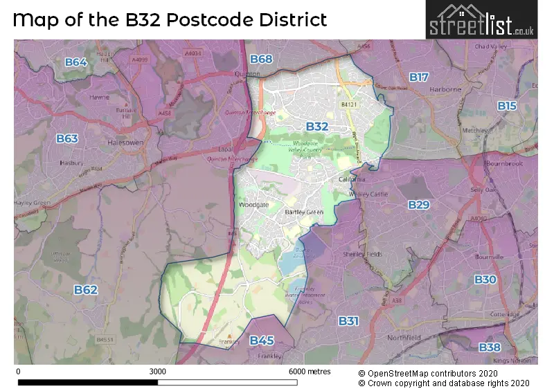
The B32 Postcode shares a border with B62 (HALESOWEN, Romsley, Hunnington), B17 (BIRMINGHAM, Harborne, Edgbaston), B68 (OLDBURY), B29 (BIRMINGHAM, Selly Oak, Selly Park), B31 (BIRMINGHAM, Northfield) and B45 (Rednal, Barnt Green, Cofton Hackett).
The primary settlement in the B32 postcode district is Quinton, located in the county of West Midlands. Additionally, there are other significant settlements in the district, including Harborne, Bartley Green, and Woodgate. The post town for the B32 postcode district is Birmingham, which is located in the West Midlands county.
For the district B32, we have data on 5 postcode sectors. Here's a breakdown: The sector B32 1, covers Quinton in West Midlands. The sector B32 2, covers Birmingham and Quinton in West Midlands. The sector B32 3, covers Birmingham in West Midlands. The sector B32 4, covers Birmingham in West Midlands. The sector B32 9 is non-geographic. It's often designated for PO Boxes, large organisations, or special services.

Map of the B32 Postcode District
Explore the B32 postcode district by using our free interactive map.
When it comes to local government, postal geography often disregards political borders. However, for a breakdown in the B32 District: the district mostly encompasses the Birmingham District (B) (750 postcodes), and finally, the Bromsgrove District area (14 postcodes).
Where is the B32 Postcode District?
The postcode district B32 is located in Birmingham. It is in close proximity to nearby towns such as Halesowen (2.38 miles to the West), Rowley Regis (3.64 miles to the North West), and Smethwick (3.71 miles to the North). Furthermore, the distance from B32 to the centre of London is approximately 102.69 miles.
The district is within the post town of BIRMINGHAM.
The sector has postcodes within the nation of England.
The B32 Postcode District is covers the following regions.
- Birmingham - West Midlands - West Midlands (England)
- Worcestershire - Herefordshire, Worcestershire and Warwickshire - West Midlands (England)
Weather Forecast for B32
Press Button to Show Forecast for Woodgate
| Time Period | Icon | Description | Temperature | Rain Probability | Wind |
|---|---|---|---|---|---|
| 09:00 to 12:00 | Sunny day | 15.0°C (feels like 14.0°C) | 0.00% | W 4 mph | |
| 12:00 to 15:00 | Sunny day | 18.0°C (feels like 17.0°C) | 0.00% | W 4 mph | |
| 15:00 to 18:00 | Sunny day | 20.0°C (feels like 19.0°C) | 0.00% | WNW 7 mph | |
| 18:00 to 21:00 | Cloudy | 20.0°C (feels like 19.0°C) | 4.00% | NNW 4 mph | |
| 21:00 to 00:00 | Partly cloudy (night) | 17.0°C (feels like 16.0°C) | 0.00% | NNE 4 mph |
Press Button to Show Forecast for Woodgate
| Time Period | Icon | Description | Temperature | Rain Probability | Wind |
|---|---|---|---|---|---|
| 00:00 to 03:00 | Clear night | 15.0°C (feels like 15.0°C) | 0.00% | NE 4 mph | |
| 03:00 to 06:00 | Partly cloudy (night) | 13.0°C (feels like 13.0°C) | 0.00% | E 4 mph | |
| 06:00 to 09:00 | Cloudy | 14.0°C (feels like 14.0°C) | 4.00% | ESE 4 mph | |
| 09:00 to 12:00 | Cloudy | 18.0°C (feels like 17.0°C) | 3.00% | SSE 4 mph | |
| 12:00 to 15:00 | Cloudy | 20.0°C (feels like 19.0°C) | 4.00% | SSE 4 mph | |
| 15:00 to 18:00 | Cloudy | 21.0°C (feels like 20.0°C) | 4.00% | S 7 mph | |
| 18:00 to 21:00 | Partly cloudy (day) | 20.0°C (feels like 19.0°C) | 0.00% | SSE 7 mph | |
| 21:00 to 00:00 | Partly cloudy (night) | 17.0°C (feels like 16.0°C) | 0.00% | SSE 7 mph |
Press Button to Show Forecast for Woodgate
| Time Period | Icon | Description | Temperature | Rain Probability | Wind |
|---|---|---|---|---|---|
| 00:00 to 03:00 | Partly cloudy (night) | 15.0°C (feels like 14.0°C) | 1.00% | SSE 7 mph | |
| 03:00 to 06:00 | Partly cloudy (night) | 13.0°C (feels like 12.0°C) | 0.00% | SSE 4 mph | |
| 06:00 to 09:00 | Partly cloudy (day) | 13.0°C (feels like 12.0°C) | 0.00% | SE 4 mph | |
| 09:00 to 12:00 | Sunny day | 17.0°C (feels like 17.0°C) | 0.00% | SE 7 mph | |
| 12:00 to 15:00 | Partly cloudy (day) | 20.0°C (feels like 18.0°C) | 1.00% | SSE 9 mph | |
| 15:00 to 18:00 | Partly cloudy (day) | 21.0°C (feels like 19.0°C) | 1.00% | SSE 9 mph | |
| 18:00 to 21:00 | Partly cloudy (day) | 20.0°C (feels like 19.0°C) | 1.00% | SSE 7 mph | |
| 21:00 to 00:00 | Partly cloudy (night) | 17.0°C (feels like 15.0°C) | 1.00% | SE 7 mph |
Press Button to Show Forecast for Woodgate
| Time Period | Icon | Description | Temperature | Rain Probability | Wind |
|---|---|---|---|---|---|
| 00:00 to 03:00 | Partly cloudy (night) | 14.0°C (feels like 13.0°C) | 0.00% | SE 9 mph | |
| 03:00 to 06:00 | Partly cloudy (night) | 12.0°C (feels like 11.0°C) | 0.00% | SE 7 mph | |
| 06:00 to 09:00 | Cloudy | 13.0°C (feels like 12.0°C) | 3.00% | ESE 7 mph | |
| 09:00 to 12:00 | Cloudy | 17.0°C (feels like 16.0°C) | 4.00% | SE 7 mph | |
| 12:00 to 15:00 | Cloudy | 20.0°C (feels like 18.0°C) | 8.00% | SSE 9 mph | |
| 15:00 to 18:00 | Cloudy | 20.0°C (feels like 18.0°C) | 15.00% | S 9 mph | |
| 18:00 to 21:00 | Light rain shower (day) | 19.0°C (feels like 17.0°C) | 37.00% | S 9 mph | |
| 21:00 to 00:00 | Cloudy | 16.0°C (feels like 14.0°C) | 14.00% | S 9 mph |
Press Button to Show Forecast for Woodgate
| Time Period | Icon | Description | Temperature | Rain Probability | Wind |
|---|---|---|---|---|---|
| 00:00 to 03:00 | Cloudy | 13.0°C (feels like 12.0°C) | 13.00% | S 9 mph | |
| 03:00 to 06:00 | Cloudy | 12.0°C (feels like 11.0°C) | 14.00% | SSW 7 mph | |
| 06:00 to 09:00 | Cloudy | 12.0°C (feels like 11.0°C) | 18.00% | SSW 7 mph | |
| 09:00 to 12:00 | Cloudy | 14.0°C (feels like 13.0°C) | 23.00% | S 9 mph | |
| 12:00 to 15:00 | Light rain shower (day) | 16.0°C (feels like 14.0°C) | 42.00% | S 11 mph | |
| 15:00 to 18:00 | Light rain shower (day) | 15.0°C (feels like 13.0°C) | 44.00% | SSW 11 mph | |
| 18:00 to 21:00 | Light rain shower (day) | 14.0°C (feels like 12.0°C) | 39.00% | SSW 11 mph | |
| 21:00 to 00:00 | Cloudy | 12.0°C (feels like 10.0°C) | 13.00% | SSW 9 mph |
| Postcode Sector | Delivery Office |
|---|---|
| B32 1 | Quinton Delivery Office |
| B32 2 | Quinton Delivery Office |
| B32 3 | Quinton Delivery Office |
| B32 4 | Quinton Delivery Office |
| B | 3 | 2 | - | X | X | X |
| B | 3 | 2 | Space | Numeric | Letter | Letter |
Current Monthly Rental Prices
| # Bedrooms | Min Price | Max Price | Avg Price |
|---|---|---|---|
| £625 | £625 | £625 | |
| 1 | £100 | £625 | £330 |
| 2 | £950 | £1,100 | £1,017 |
| 3 | £950 | £1,400 | £1,155 |
| 4 | £1,300 | £1,992 | £1,629 |
Current House Prices
| # Bedrooms | Min Price | Max Price | Avg Price |
|---|---|---|---|
| 3 | £300,000 | £440,000 | £352,857 |
| 4 | £375,000 | £750,000 | £501,231 |
| 5 | £400,000 | £530,000 | £460,000 |
Estate Agents who Operate in the B32 District
| Logo | Name | Brand Name | Address | Contact Number | Total Properties |
|---|---|---|---|---|---|
 | Harborne | Shipways | 172 High Street, Harborne, B17 9PP | 0121 387 6295 | 17 |
 | Harborne | Oakmans Estate Agents | 99 High Street High Street, Harborne, Birmingham, B17 9NR | 0121 387 6779 | 16 |
 | B'ham West - Harborne | Connells | 158 High Street, Harborne, B17 9QE | 0121 387 6257 | 13 |
 | Quinton | Humberstones Homes | 787 / 789 Hagley Road West, Quinton, Birmingham, B32 1AJ | 0121 661 6993 | 8 |
 | Quinton | Dixons | 508 Hagley Road West, Oldbury, West Midlands, B68 0BZ | 0121 387 6279 | 6 |
Yearly House Price Averages for the B32 Postcode District
| Type of Property | 2018 Average | 2018 Sales | 2017 Average | 2017 Sales | 2016 Average | 2016 Sales | 2015 Average | 2015 Sales |
|---|---|---|---|---|---|---|---|---|
| Detached | £280,799 | 41 | £303,295 | 91 | £315,033 | 70 | £257,438 | 35 |
| Semi-Detached | £193,593 | 181 | £188,504 | 215 | £163,242 | 194 | £147,562 | 200 |
| Terraced | £143,311 | 208 | £142,550 | 221 | £133,304 | 226 | £129,372 | 215 |
| Flats | £141,665 | 40 | £83,952 | 39 | £100,293 | 43 | £64,925 | 34 |