The B32 3 postcode sector is within the county of West Midlands.
Did you know? According to the 2021 Census, the B32 3 postcode sector is home to a bustling 11,527 residents!
Given that each sector allows for 400 unique postcode combinations. Letters C, I, K, M, O and V are not allowed in the last two letters of a postcode. With 228 postcodes already in use, this leaves 172 units available.
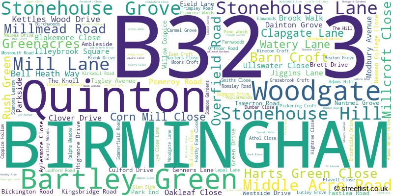
The largest settlement in the B32 3 postal code is BIRMINGHAM followed by Quinton, and Bartley Green.
The B32 3 Postcode shares a border with B32 1 (Quinton, BIRMINGHAM), B62 0 (HALESOWEN, Romsley, Hunnington), B29 5 (BIRMINGHAM), B31 1 (BIRMINGHAM, Northfield), B31 5 (BIRMINGHAM, Northfield), B32 2 (Quinton, BIRMINGHAM, Harborne) and B32 4 (BIRMINGHAM, Woodgate, Bartley Green).
The sector is within the post town of BIRMINGHAM.
B32 3 is a postcode sector within the B32 postcode district which is within the B Birmingham postcode area.
The Royal Mail delivery office for the B32 3 postal sector is the Quinton Delivery Office.
The area of the B32 3 postcode sector is 1.46 square miles which is 3.79 square kilometres or 936.48 square acres.

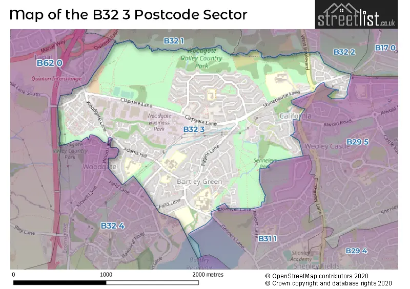
Map of the B32 3 Postcode Sector
Explore the B32 3 postcode sector by using our free interactive map.
| B | 3 | 2 | - | 3 | X | X |
| B | 3 | 2 | Space | 3 | Letter | Letter |
Official List of Streets
BIRMINGHAM (123 Streets)
Woodgate (1 Streets)
Bartley Green (5 Streets)
Unofficial Streets or Alternative Spellings
BIRMINGHAM
BARNES HILL CROMWELL LANE MINTON ROAD MOORS LANE SOMERY ROAD WENTWORTH WAYQuinton
FIELD LANE WEST BOULEVARD BOURN BROOK WALKWAY BOURNVALE WALK CALIFORNIA WAY CARTERS LANE GENNERS APPROACH GREEN ACRES MONTFORD WALKWoodgate
MOAT COPPICE WOOD LANEBIRMINGHAM,
LYE CLOSE LANEWeather Forecast for B32 3
Press Button to Show Forecast for Woodgate
| Time Period | Icon | Description | Temperature | Rain Probability | Wind |
|---|---|---|---|---|---|
| 03:00 to 06:00 | Cloudy | 5.0°C (feels like 1.0°C) | 10.00% | ENE 11 mph | |
| 06:00 to 09:00 | Overcast | 4.0°C (feels like 1.0°C) | 15.00% | ENE 9 mph | |
| 09:00 to 12:00 | Overcast | 6.0°C (feels like 3.0°C) | 56.00% | ENE 11 mph | |
| 12:00 to 15:00 | Light rain | 6.0°C (feels like 3.0°C) | 78.00% | ENE 11 mph | |
| 15:00 to 18:00 | Overcast | 7.0°C (feels like 4.0°C) | 17.00% | ENE 11 mph | |
| 18:00 to 21:00 | Overcast | 7.0°C (feels like 3.0°C) | 17.00% | NE 11 mph | |
| 21:00 to 00:00 | Overcast | 6.0°C (feels like 2.0°C) | 12.00% | NE 11 mph |
Press Button to Show Forecast for Woodgate
| Time Period | Icon | Description | Temperature | Rain Probability | Wind |
|---|---|---|---|---|---|
| 00:00 to 03:00 | Cloudy | 5.0°C (feels like 1.0°C) | 12.00% | NE 11 mph | |
| 03:00 to 06:00 | Overcast | 5.0°C (feels like 1.0°C) | 19.00% | NNE 13 mph | |
| 06:00 to 09:00 | Light rain | 5.0°C (feels like 1.0°C) | 50.00% | N 11 mph | |
| 09:00 to 12:00 | Light rain | 6.0°C (feels like 3.0°C) | 48.00% | NNW 11 mph | |
| 12:00 to 15:00 | Overcast | 8.0°C (feels like 5.0°C) | 19.00% | NW 11 mph | |
| 15:00 to 18:00 | Overcast | 9.0°C (feels like 7.0°C) | 16.00% | WNW 9 mph | |
| 18:00 to 21:00 | Cloudy | 9.0°C (feels like 7.0°C) | 8.00% | WSW 9 mph | |
| 21:00 to 00:00 | Clear night | 6.0°C (feels like 4.0°C) | 2.00% | SW 7 mph |
Press Button to Show Forecast for Woodgate
| Time Period | Icon | Description | Temperature | Rain Probability | Wind |
|---|---|---|---|---|---|
| 00:00 to 03:00 | Clear night | 4.0°C (feels like 2.0°C) | 1.00% | SW 7 mph | |
| 03:00 to 06:00 | Clear night | 3.0°C (feels like 0.0°C) | 2.00% | SSW 9 mph | |
| 06:00 to 09:00 | Sunny day | 4.0°C (feels like 1.0°C) | 2.00% | S 11 mph | |
| 09:00 to 12:00 | Partly cloudy (day) | 9.0°C (feels like 6.0°C) | 2.00% | S 13 mph | |
| 12:00 to 15:00 | Overcast | 12.0°C (feels like 9.0°C) | 10.00% | S 16 mph | |
| 15:00 to 18:00 | Cloudy | 12.0°C (feels like 9.0°C) | 9.00% | S 16 mph | |
| 18:00 to 21:00 | Partly cloudy (day) | 11.0°C (feels like 9.0°C) | 4.00% | S 13 mph | |
| 21:00 to 00:00 | Clear night | 9.0°C (feels like 6.0°C) | 3.00% | SSE 13 mph |
Press Button to Show Forecast for Woodgate
| Time Period | Icon | Description | Temperature | Rain Probability | Wind |
|---|---|---|---|---|---|
| 00:00 to 03:00 | Clear night | 7.0°C (feels like 4.0°C) | 4.00% | SSE 13 mph | |
| 03:00 to 06:00 | Clear night | 7.0°C (feels like 3.0°C) | 3.00% | SE 13 mph | |
| 06:00 to 09:00 | Sunny day | 7.0°C (feels like 4.0°C) | 5.00% | SE 13 mph | |
| 09:00 to 12:00 | Sunny day | 11.0°C (feels like 9.0°C) | 7.00% | SE 13 mph | |
| 12:00 to 15:00 | Cloudy | 14.0°C (feels like 11.0°C) | 17.00% | SE 13 mph | |
| 15:00 to 18:00 | Partly cloudy (day) | 14.0°C (feels like 12.0°C) | 14.00% | SE 13 mph | |
| 18:00 to 21:00 | Cloudy | 13.0°C (feels like 11.0°C) | 12.00% | SE 11 mph | |
| 21:00 to 00:00 | Cloudy | 11.0°C (feels like 9.0°C) | 11.00% | ESE 9 mph |
Schools and Places of Education Within the B32 3 Postcode Sector
Bartley Green School
Academy converter
Adams Hill, Birmingham, West Midlands, B32 3QJ
Head: Jane Chan
Ofsted Rating: Good
Inspection: 2023-03-08 (416 days ago)
Website: Visit Bartley Green School Website
Phone: 01214769246
Number of Pupils: 932
Hillcrest School and Sixth Form Centre
Academy converter
Stonehouse Lane, Birmingham, West Midlands, B32 3AE
Head: Julie Ann Davies
Ofsted Rating: Good
Inspection: 2022-09-28 (577 days ago)
Website: Visit Hillcrest School and Sixth Form Centre Website
Phone: 01214643172
Number of Pupils: 650
Nonsuch Primary School
Academy converter
Wood Leasow, Birmingham, West Midlands, B32 3SE
Head: Mr Carl Watkins
Ofsted Rating: Good
Inspection: 2021-10-06 (934 days ago)
Website: Visit Nonsuch Primary School Website
Phone: 01214642064
Number of Pupils: 195
St Michael's Church of England Primary School
Academy converter
Nantmel Grove, Birmingham, West Midlands, B32 3JS
Head: Mrs Sally Roberts
Ofsted Rating: Good
Inspection: 2022-10-19 (556 days ago)
Website: Visit St Michael's Church of England Primary School Website
Phone: 01214644345
Number of Pupils: 433
St Peter's Catholic Primary School
Voluntary aided school
Adams Hill, Birmingham, West Midlands, B32 3QD
Head: Mrs Joanna McAleenan
Ofsted Rating: Outstanding
Inspection: 2019-07-10 (1753 days ago)
Website: Visit St Peter's Catholic Primary School Website
Phone: 01214646921
Number of Pupils: 208
Woodgate Primary School
Community school
Lutley Grove, Birmingham, West Midlands, B32 3PN
Head: Mrs Deborah Colley
Ofsted Rating: Good
Inspection: 2019-06-26 (1767 days ago)
Website: Visit Woodgate Primary School Website
Phone: 01214642315
Number of Pupils: 404
House Prices in the B32 3 Postcode Sector
| Type of Property | 2018 Average | 2018 Sales | 2017 Average | 2017 Sales | 2016 Average | 2016 Sales | 2015 Average | 2015 Sales |
|---|---|---|---|---|---|---|---|---|
| Detached | £282,500 | 14 | £265,392 | 30 | £220,368 | 14 | £207,989 | 9 |
| Semi-Detached | £153,591 | 33 | £152,860 | 39 | £125,984 | 41 | £133,169 | 34 |
| Terraced | £127,399 | 69 | £128,420 | 83 | £115,619 | 68 | £105,676 | 65 |
| Flats | £75,500 | 4 | £71,425 | 14 | £67,325 | 12 | £56,100 | 15 |
Important Postcodes B32 3 in the Postcode Sector
B32 3AE is the postcode for Hillcrest School, Stonehouse Lane
B32 3AG is the postcode for West Midlands Fire Service, Woodgate Valley Fire Station, 161 Stonehouse Lane
B32 3JS is the postcode for St. Michaels C of E Junior & Infant School, Nantmel Grove
B32 3NT is the postcode for COFTON HALL, Newman University, Genners Lane, MCAULEY, Newman University, Genners Lane, DWYER BUILDING, Newman University, Genners Lane, SPORTS CENTRE, Newman University, Genners Lane, ARTS BLOCK, Newman University, Genners Lane, DARWIN BUILDING, Newman University, Genners Lane, EDWARDS BUILDING, Newman University, Genners Lane, A, B & C BLOCKS AND CHAPEL, Newman University, Genners Lane, LIBRARY AND STUDENT SUPPORT CENTRE, Newman University, Genners Lane, EDGBASTON, LITTLEMORE & MARYVALE HALLS AND JULIAN OF NORWICH BUILDING, Newman University, Genners Lane, ADMINISTRATION AND THEATRE BLOCKS, Newman University, Genners Lane, OXFORD HALL, Newman University, Genners Lane, SCIENCE BLOCK, Newman University, Genners Lane, ST CHAD BUILDING, Newman University, Genners Lane, and STURGE, ELGAR, BARBERI, AND DUPUIS BUILDINGS, Newman University, Genners Lane
B32 3PN is the postcode for Woodgate Primary School, Lutley Grove, and BIRMINGHAM CITY COUNCIL, Woodgate Primary School, Lutley Grove
B32 3PR is the postcode for Bartley Green Medical Practice, 71 Romsley Road
B32 3QD is the postcode for St. Peters RC Junior & Infant School, Adams Hill, and St Peter's Catholic Primary School, Adams Hill
B32 3QJ is the postcode for C BLOCK, Bartley Green School, Adams Hill, Bartley Green School, Adams Hill, and A BLOCK, Bartley Green School, Adams Hill
B32 3SD is the postcode for Woodgate Valley Health Centre, 61 Stevens Avenue, and Woodgate Valley Primary Care Centre, 61 Stevens Avenue
B32 3SE is the postcode for Nonsuch Primary School, Wood Leasow, and BIRMINGHAM CITY COUNCIL, Nonsuch Primary School, Wood Leasow
| The B32 3 Sector is within these Local Authorities |
|
|---|---|
| The B32 3 Sector is within these Counties |
|
| The B32 3 Sector is within these Water Company Areas |
|