The B19 1 postcode sector is within the county of West Midlands.
Did you know? According to the 2021 Census, the B19 1 postcode sector is home to a bustling 10,161 residents!
Given that each sector allows for 400 unique postcode combinations. Letters C, I, K, M, O and V are not allowed in the last two letters of a postcode. With 144 postcodes already in use, this leaves 256 units available.
The largest settlement in the B19 1 postal code is BIRMINGHAM followed by Lozells, and Handsworth.
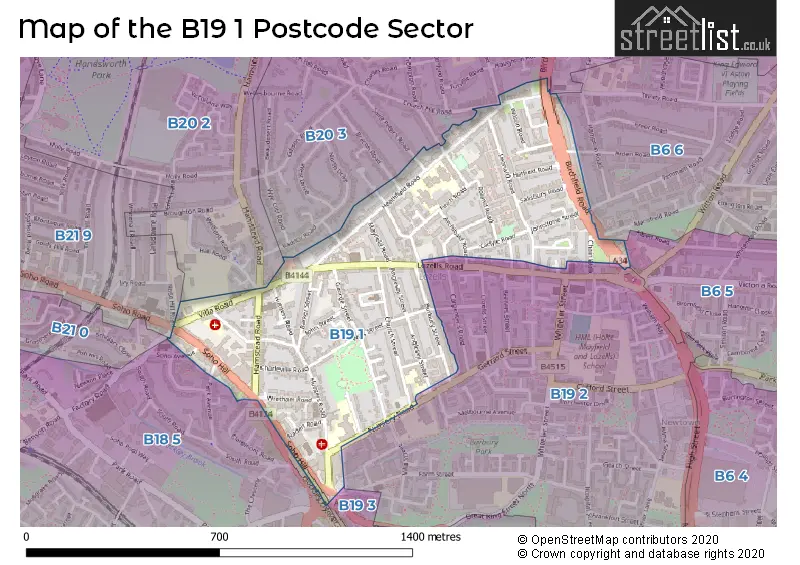
The B19 1 Postcode shares a border with B18 5 (Hockley, BIRMINGHAM), B19 3 (BIRMINGHAM, Hockley), B6 5 (Aston, BIRMINGHAM), B6 6 (BIRMINGHAM, Aston), B19 2 (BIRMINGHAM, Hockley, Lozells), B20 2 (BIRMINGHAM, Handsworth), B20 3 (BIRMINGHAM, Handsworth), B21 0 (BIRMINGHAM, Handsworth) and B21 9 (Handsworth, BIRMINGHAM).
The sector is within the post town of BIRMINGHAM.
B19 1 is a postcode sector within the B1 postcode district which is within the B Birmingham postcode area.
The Royal Mail delivery office for the B19 1 postal sector is the Birmingham Central Delivery Office.
The area of the B19 1 postcode sector is 0.36 square miles which is 0.93 square kilometres or 230.34 square acres.

Map of the B19 1 Postcode Sector
Explore the B19 1 postcode sector by using our free interactive map.
| B | 1 | 9 | - | 1 | X | X |
| B | 1 | 9 | Space | 1 | Letter | Letter |
Official List of Streets
BIRMINGHAM (41 Streets)
Lozells (8 Streets)
Handsworth (2 Streets)
Birchfield (1 Streets)
Unofficial Streets or Alternative Spellings
BIRMINGHAM
BRECON ROAD CHURCH HILL ROAD HEATHFIELD AVENUE HOCKLEY CIRCUS HOCKLEY HILL ROSE HILL ROAD SOHO AVENUE SOHO ROAD TRINITY ROADHandsworth
CROMPTON ROAD HAMSTEAD ROAD WESTMINSTER ROADAston
ARDEN ROAD ARDEN GROVE BEDFORD TERRACE / WESTERN TERRACE FINCHLEY AVENUE FLADBURY GARDENS HAROLD TERRACE HAWTHORN GROVE HOCKLEY FLYOVER LEONARD AVENUE LEONARD GROVE MAPLE GROVE MELROSE GROVE MYRTLE GROVE POPLAR AVENUE POPLAR GROVE ROLAND TERRACE SAINT PETERS ROAD SOUTH GROVE SPRING GROVE ST MICHAELS ROAD ST PETERS ROAD THE AVENUE THE GROVEHockley
NURSERY ROAD PARK AVENUESchools and Places of Education Within the B19 1 Postcode Sector
Anglesey Primary School
Community school
Anglesey Street, Birmingham, West Midlands, B19 1RA
Head: Mr Adrian Pembleton
Ofsted Rating: Good
Inspection: 2022-11-23 (547 days ago)
Website: Visit Anglesey Primary School Website
Phone: 01214644388
Number of Pupils: 733
Aspire AP School 2
Other independent school
240-244 Lozells Road, Birmingham, West Midlands, B19 1NP
Head: Mr James Lawlor
Ofsted Rating: Good
Inspection: 2021-11-25 (910 days ago)
Website: Visit Aspire AP School 2 Website
Phone: 07943183021
Number of Pupils: 7
Heathfield Primary School
Academy converter
Heathfield Road, Birmingham, West Midlands, B19 1HJ
Head: Yasmeen Malik
Ofsted Rating: Good
Inspection: 2018-06-13 (2171 days ago)
Website: Visit Heathfield Primary School Website
Phone: 01214646474
Number of Pupils: 472
St Francis Catholic Primary School
Voluntary aided school
Nursery Road, Birmingham, West Midlands, B19 1PH
Head: Miss Margaret Brumant
Ofsted Rating: Good
Inspection: 2019-07-10 (1779 days ago)
Website: Visit St Francis Catholic Primary School Website
Phone: 01214645072
Number of Pupils: 384
House Prices in the B19 1 Postcode Sector
| Type of Property | 2018 Average | 2018 Sales | 2017 Average | 2017 Sales | 2016 Average | 2016 Sales | 2015 Average | 2015 Sales |
|---|---|---|---|---|---|---|---|---|
| Detached | £0 | 0 | £200,000 | 1 | £90,000 | 1 | £0 | 0 |
| Semi-Detached | £0 | 0 | £145,333 | 3 | £182,000 | 2 | £206,250 | 2 |
| Terraced | £120,511 | 27 | £101,368 | 22 | £102,996 | 24 | £100,214 | 32 |
| Flats | £0 | 0 | £0 | 0 | £65,000 | 1 | £0 | 0 |
Important Postcodes B19 1 in the Postcode Sector
B19 1BH is the postcode for King Edward VI Handsworth School Performing Arts Centre, 1 Villa Road
B19 1BP is the postcode for Medical Centre, Orsborn House, 55 Terrace Road
B19 1DR is the postcode for Birmingham Primary Care Shared Services Agency, Carnegie Centre, Hunters Road, and Carnegie Centre, Hunters Road
B19 1HJ is the postcode for Heathfield Primary Academy, Heathfield Road, Heathfield Primary Academy, Heathfield Road, Handsworth, Lime Tree Childrens Centre, Heathfield Road, Mayfield School, Heathfield Road, and HYDRO POOL, Mayfield Centre, Heathfield Road
B19 1HL is the postcode for Heathfield Family Centre, 133 Heathfield Road
B19 1HS is the postcode for Finch Road Primary Care Centre, 2 Finch Road
B19 1PH is the postcode for St Francis Primary School, Brougham Street, and St. Francis' Catholic Primary School, Brougham Street
B19 1RA is the postcode for JUNIOR BLOCK, Anglesey Primary School, Anglesey Street, INFANTS BLOCK, Anglesey Primary School, Anglesey Street, INFANT DEPARTMENT, Anglesey Primary School, Anglesey Street, and Anglesey Primary School, Anglesey Street
B19 1TT is the postcode for 311, Burbury Street
| The B19 1 Sector is within these Local Authorities |
|
|---|---|
| The B19 1 Sector is within these Counties |
|
| The B19 1 Sector is within these Water Company Areas |
|