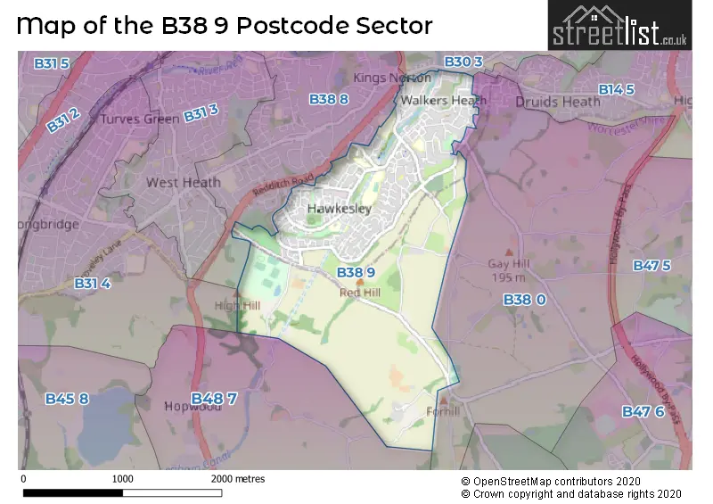
The B38 9 postcode sector stands on the West Midlands and Worcestershire border.
Did you know? According to the 2021 Census, the B38 9 postcode sector is home to a bustling 10,103 residents!
Given that each sector allows for 400 unique postcode combinations. Letters C, I, K, M, O and V are not allowed in the last two letters of a postcode. With 205 postcodes already in use, this leaves 195 units available.
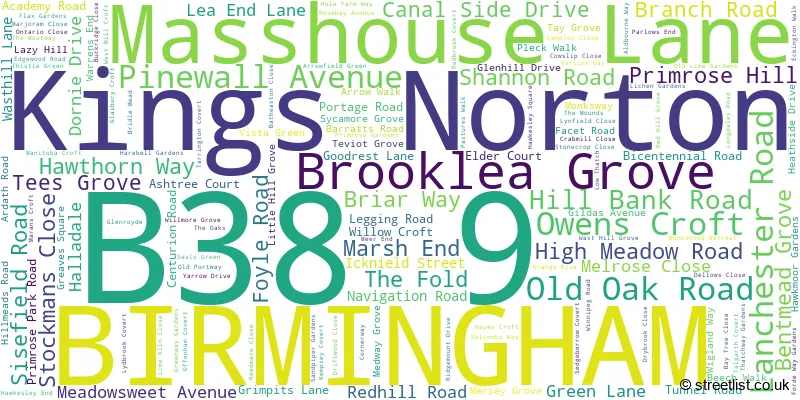
The largest settlements in the B38 9 postal code are BIRMINGHAM and Kings Norton.
The B38 9 Postcode shares a border with B48 7 (Alvechurch, Portway), B30 3 (BIRMINGHAM, Kings Norton, Stirchley), B31 4 (BIRMINGHAM, Northfield), B38 0 (BIRMINGHAM, Kings Norton) and B38 8 (BIRMINGHAM, Kings Norton).
The sector is within the post town of BIRMINGHAM.
B38 9 is a postcode sector within the B38 postcode district which is within the B Birmingham postcode area.
The Royal Mail delivery office for the B38 9 postal sector is the Kings Norton Delivery Office.
The area of the B38 9 postcode sector is 2.04 square miles which is 5.27 square kilometres or 1,302.94 square acres.
Waterways within the B38 9 postcode sector include the Worcester & Birmingham Canal, Wast Hill Tunnel.

Map of the B38 9 Postcode Sector
Explore the B38 9 postcode sector by using our free interactive map.
| B | 3 | 8 | - | 9 | X | X |
| B | 3 | 8 | Space | 9 | Letter | Letter |
Official List of Streets
BIRMINGHAM (126 Streets)
Kings Norton (8 Streets)
Unofficial Streets or Alternative Spellings
Weather Forecast for B38 9
Press Button to Show Forecast for West Heath
| Time Period | Icon | Description | Temperature | Rain Probability | Wind |
|---|---|---|---|---|---|
| 03:00 to 06:00 | Partly cloudy (night) | 7.0°C (feels like 4.0°C) | 1.00% | SSE 11 mph | |
| 06:00 to 09:00 | Sunny day | 7.0°C (feels like 4.0°C) | 1.00% | SE 11 mph | |
| 09:00 to 12:00 | Sunny day | 12.0°C (feels like 9.0°C) | 1.00% | SSE 13 mph | |
| 12:00 to 15:00 | Partly cloudy (day) | 15.0°C (feels like 12.0°C) | 5.00% | SSE 16 mph | |
| 15:00 to 18:00 | Cloudy | 15.0°C (feels like 12.0°C) | 8.00% | SSE 16 mph | |
| 18:00 to 21:00 | Cloudy | 13.0°C (feels like 11.0°C) | 10.00% | S 11 mph | |
| 21:00 to 00:00 | Cloudy | 10.0°C (feels like 9.0°C) | 12.00% | SSE 7 mph |
Press Button to Show Forecast for West Heath
| Time Period | Icon | Description | Temperature | Rain Probability | Wind |
|---|---|---|---|---|---|
| 00:00 to 03:00 | Cloudy | 9.0°C (feels like 8.0°C) | 12.00% | SSE 7 mph | |
| 03:00 to 06:00 | Cloudy | 8.0°C (feels like 7.0°C) | 8.00% | SSE 4 mph | |
| 06:00 to 09:00 | Cloudy | 8.0°C (feels like 7.0°C) | 10.00% | SE 4 mph | |
| 09:00 to 12:00 | Cloudy | 11.0°C (feels like 10.0°C) | 9.00% | ESE 4 mph | |
| 12:00 to 15:00 | Cloudy | 13.0°C (feels like 12.0°C) | 14.00% | ENE 4 mph | |
| 15:00 to 18:00 | Cloudy | 14.0°C (feels like 13.0°C) | 17.00% | NE 4 mph | |
| 18:00 to 21:00 | Cloudy | 14.0°C (feels like 12.0°C) | 14.00% | NNE 9 mph | |
| 21:00 to 00:00 | Cloudy | 12.0°C (feels like 10.0°C) | 12.00% | NE 9 mph |
Press Button to Show Forecast for West Heath
| Time Period | Icon | Description | Temperature | Rain Probability | Wind |
|---|---|---|---|---|---|
| 00:00 to 03:00 | Cloudy | 10.0°C (feels like 8.0°C) | 14.00% | N 9 mph | |
| 03:00 to 06:00 | Cloudy | 10.0°C (feels like 7.0°C) | 15.00% | N 11 mph | |
| 06:00 to 09:00 | Overcast | 9.0°C (feels like 7.0°C) | 14.00% | NNW 11 mph | |
| 09:00 to 12:00 | Cloudy | 12.0°C (feels like 10.0°C) | 11.00% | N 11 mph | |
| 12:00 to 15:00 | Cloudy | 15.0°C (feels like 13.0°C) | 7.00% | N 11 mph | |
| 15:00 to 18:00 | Partly cloudy (day) | 17.0°C (feels like 14.0°C) | 3.00% | N 11 mph | |
| 18:00 to 21:00 | Sunny day | 16.0°C (feels like 13.0°C) | 5.00% | N 11 mph | |
| 21:00 to 00:00 | Clear night | 12.0°C (feels like 10.0°C) | 4.00% | N 11 mph |
Schools and Places of Education Within the B38 9 Postcode Sector
Ark Kings Academy
Academy sponsor led
Shannon Road, Birmingham, West Midlands, B38 9DE
Head: Mrs Caz Brasenell
Ofsted Rating: Special Measures
Inspection: 2022-02-09 (811 days ago)
Website: Visit Ark Kings Academy Website
Phone: 01214594451
Number of Pupils: 827
Hawkesley Church Primary Academy
Academy sponsor led
376 Shannon Road, Birmingham, West Midlands, B38 9TR
Head: Miss Petrina Poleon
Ofsted Rating: Good
Inspection: 2021-10-13 (930 days ago)
Website: Visit Hawkesley Church Primary Academy Website
Phone: 01214596467
Number of Pupils: 230
New Ways School
Other independent school
300 Redhill road, , West Midlands, B38 9EL
Head: Miss Michelle Woodward
Ofsted Rating: Outstanding
Inspection: 2023-03-09 (418 days ago)
Website: Visit New Ways School Website
Phone: 07974256232
Number of Pupils: 24
St Paul's Catholic Primary School
Academy converter
Sisefield Road, Birmingham, West Midlands, B38 9JB
Head: Mrs Haylia Williams
Ofsted Rating: Good
Inspection: 2021-11-17 (895 days ago)
Website: Visit St Paul's Catholic Primary School Website
Phone: 01214641546
Number of Pupils: 191
House Prices in the B38 9 Postcode Sector
| Type of Property | 2018 Average | 2018 Sales | 2017 Average | 2017 Sales | 2016 Average | 2016 Sales | 2015 Average | 2015 Sales |
|---|---|---|---|---|---|---|---|---|
| Detached | £265,274 | 9 | £306,663 | 3 | £203,452 | 12 | £317,828 | 18 |
| Semi-Detached | £172,770 | 37 | £158,257 | 35 | £156,603 | 38 | £165,078 | 38 |
| Terraced | £131,316 | 55 | £124,084 | 69 | £120,867 | 61 | £109,770 | 55 |
| Flats | £92,194 | 22 | £134,958 | 12 | £118,391 | 26 | £90,850 | 10 |
Important Postcodes B38 9 in the Postcode Sector
B38 9DE is the postcode for ARK Kings Academy, Shannon Road, Main Block, ARK Kings Academy, Shannon Road, TEACHING BLOCK, ARK Kings Academy, Shannon Road, and SPORTS HALL, ARK Kings Academy, Shannon Road
B38 9DH is the postcode for ARK Kings Academy, Tees Grove, and ARK Rose Academy, Tees Grove
B38 9JB is the postcode for St. Pauls RC Primary School, 77 Sisefield Road
B38 9JX is the postcode for Kings Norton Children's Centre, 5 Teviot Grove
B38 9NE is the postcode for Hillmeads Health Centre, 97 Hillmeads Road
B38 9RU is the postcode for 95-101, Edgewood Road, Kings Norton
B38 9TJ is the postcode for Hawkesley Health Centre, 375 Shannon Road
B38 9TR is the postcode for Hawkesley Church Primary Academy, 376 Shannon Road
B38 9TS is the postcode for Birmingham City Council, Hawkesley Centre, Stockmans Close, Bilton Industrial Estate
| The B38 9 Sector is within these Local Authorities |
|
|---|---|
| The B38 9 Sector is within these Counties |
|
| The B38 9 Sector is within these Water Company Areas |
|