The B66 2 postcode sector is within the county of West Midlands.
Did you know? According to the 2021 Census, the B66 2 postcode sector is home to a bustling 3,037 residents!
Given that each sector allows for 400 unique postcode combinations. Letters C, I, K, M, O and V are not allowed in the last two letters of a postcode. With 125 postcodes already in use, this leaves 275 units available.
The largest settlements in the B66 2 postal code are SMETHWICK and Middlemore Industrial Estate.
The B66 2 Postcode shares a border with B66 4 (SMETHWICK), B16 0 (BIRMINGHAM, Edgbaston), B18 4 (BIRMINGHAM, Hockley, Winson Green), B21 0 (BIRMINGHAM, Handsworth), B66 1 (SMETHWICK), B66 3 (SMETHWICK, French Walls) and B71 4 (WEST BROMWICH, Sandwell).
The sector is within the post town of SMETHWICK.
B66 2 is a postcode sector within the B66 postcode district which is within the B Birmingham postcode area.
The Royal Mail delivery office for the B66 2 postal sector is the Smethwick Delivery Office.
The area of the B66 2 postcode sector is 0.68 square miles which is 1.76 square kilometres or 435.72 square acres.
Waterways within the B66 2 postcode sector include the Birmingham Canal, Birmingham Canal (New Main Line), Engine Arm, Engine Arm Aqueduct.

Map of the B66 2 Postcode Sector
Explore the B66 2 postcode sector by using our free interactive map.
| B | 6 | 6 | - | 2 | X | X |
| B | 6 | 6 | Space | 2 | Letter | Letter |
Official List of Streets
SMETHWICK (62 Streets)
Middlemore Industrial Estate (1 Streets)
Unofficial Streets or Alternative Spellings
BIRMINGHAM,
BOOTH STREET HEATH STREET WATTVILLE ROAD WELLINGTON STREETBIRMINGHAM
DUDLEY ROAD DUGDALE STREET WINSON STREETSMETHWICK
BUTTRESS WAY CAPE HILL DOULTON DRIVE ENGINE STREET FRENCH WALLS WAY GROVE CLOSE HAMILTON DRIVE RABONE LANE TOLLHOUSE WAY UNETT STREET WHITEHOUSE DRIVE WILLIAM STREET WEST WINDMILL LANE ALFRED STREET BOULTON ROAD CHARLES STREET HILL STREET JOHN GUES CLOSE KITCHENER STREET MELBOURNE AVENUE METRO WAY MIDDLEMORE BUSINESS PARK MOILLIETT COURT NORTH WESTERN ROAD PARKROSE INDUSTRIAL ESTATE SMETHWICK ENTERPRISE CENTREHandsworth
MIDDLEMORE ROADSMETHWICK,
HALFORDS LANE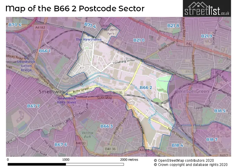
House Prices in the B66 2 Postcode Sector
| Type of Property | 2018 Average | 2018 Sales | 2017 Average | 2017 Sales | 2016 Average | 2016 Sales | 2015 Average | 2015 Sales |
|---|---|---|---|---|---|---|---|---|
| Detached | £248,071 | 27 | £215,135 | 12 | £0 | 0 | £0 | 0 |
| Semi-Detached | £201,698 | 58 | £175,295 | 24 | £75,000 | 1 | £137,000 | 1 |
| Terraced | £125,613 | 8 | £94,278 | 9 | £100,667 | 9 | £76,800 | 5 |
| Flats | £0 | 0 | £0 | 0 | £0 | 0 | £0 | 0 |
Important Postcodes B66 2 in the Postcode Sector
B66 2NN is the postcode for Unit 2, Rabone Park, Rabone Lane, Smethwick Dialysis Centre, Unit 2, and Smethwick Dialysis Centre, Unit 2, Rabone Park
| The B66 2 Sector is within these Local Authorities |
|
|---|---|
| The B66 2 Sector is within these Counties |
|
| The B66 2 Sector is within these Water Company Areas |
|