The B76 9 postcode sector stands on the Warwickshire and West Midlands border.
Did you know? According to the 2021 Census, the B76 9 postcode sector is home to a bustling 3,010 residents!
Given that each sector allows for 400 unique postcode combinations. Letters C, I, K, M, O and V are not allowed in the last two letters of a postcode. With 103 postcodes already in use, this leaves 297 units available.
The largest settlement in the B76 9 postal code is Minworth followed by Curdworth, and Wishaw.
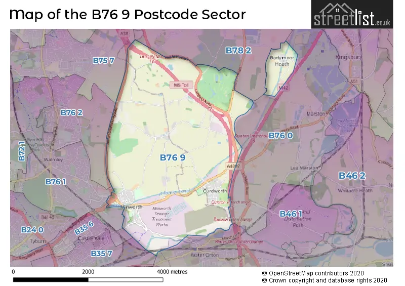
The B76 9 Postcode shares a border with B46 1 (Coleshill, Water Orton), B76 0 (Lea Marston, Marston, Curdworth), B76 1 (SUTTON COLDFIELD, Minworth), B76 2 (SUTTON COLDFIELD), B35 6 (BIRMINGHAM, Castle Vale), B35 7 (BIRMINGHAM, Castle Vale), B75 7 (SUTTON COLDFIELD) and B78 2 (Kingsbury, Middleton, Piccadilly).
The sector is within the post town of SUTTON COLDFIELD.
B76 9 is a postcode sector within the B7 postcode district which is within the B Birmingham postcode area.
The Royal Mail delivery office for the B76 9 postal sector is the unknown.
The area of the B76 9 postcode sector is 6.38 square miles which is 16.52 square kilometres or 4,082.19 square acres.
The B76 9 postcode sector is crossed by the A446 Major A road.
The B76 9 postcode sector is crossed by the M6 motorway.
The B76 9 postcode sector is crossed by the A38 Major A road.
The B76 9 postcode sector is crossed by the M42 motorway.
The B76 9 postcode sector is crossed by the A4097 Major A road.
Waterways within the B76 9 postcode sector include the Birmingham and Fazeley Canal, Birmingham & Fazeley Canal, Langley Brook, Churchill Brook, River Tame.

Map of the B76 9 Postcode Sector
Explore the B76 9 postcode sector by using our free interactive map.
| B | 7 | 6 | - | 9 | X | X |
| B | 7 | 6 | Space | 9 | Letter | Letter |
Official List of Streets
Minworth (28 Streets)
Curdworth (15 Streets)
Bodymoor Heath (2 Streets)
Wishaw (13 Streets)
Unofficial Streets or Alternative Spellings
Middleton
MIDDLETON LANE TAMWORTH ROAD WISHAW LANECurdworth
MARSH LANEBassetts Pole
LONDON ROADMinworth
STOCKTON CLOSE WALMLEY ASH ROADCastle Vale
KINGSBURY ROAD PARK LANESUTTON COLDFIELD
LINDRIDGE ROADSchools and Places of Education Within the B76 9 Postcode Sector
Curdworth Primary School
Academy converter
Farthing Lane, Sutton Coldfield, West Midlands, B76 9HF
Head: Mrs Jaspreet Kang
Ofsted Rating: Good
Inspection: 2023-02-28 (450 days ago)
Website: Visit Curdworth Primary School Website
Phone: 01675470379
Number of Pupils: 114
Minworth Junior and Infant School
Community school
Water Orton Lane, SUTTON COLDFIELD, West Midlands, B76 9BU
Head: Miss Kelly Lickley
Ofsted Rating: Good
Inspection: 2019-12-04 (1632 days ago)
Website: Visit Minworth Junior and Infant School Website
Phone: 01213511345
Number of Pupils: 206
House Prices in the B76 9 Postcode Sector
| Type of Property | 2018 Average | 2018 Sales | 2017 Average | 2017 Sales | 2016 Average | 2016 Sales | 2015 Average | 2015 Sales |
|---|---|---|---|---|---|---|---|---|
| Detached | £476,947 | 19 | £360,542 | 12 | £514,125 | 12 | £310,773 | 11 |
| Semi-Detached | £217,267 | 15 | £194,682 | 11 | £194,694 | 17 | £173,720 | 15 |
| Terraced | £231,430 | 15 | £171,977 | 11 | £205,458 | 12 | £163,750 | 6 |
| Flats | £114,833 | 3 | £119,288 | 13 | £115,690 | 5 | £106,667 | 3 |
Important Postcodes B76 9 in the Postcode Sector
B76 9BU is the postcode for Minworth Junior & Infant School, Water Orton Lane
B76 9HF is the postcode for Curdworth Primary School, Farthing Lane, Curdworth, and Curdworth Primary School, Farthing Lane
B76 9JB is the postcode for Kingsbury Water Park Outdoor Education Centre, Bodymoor Heath Lane
| The B76 9 Sector is within these Local Authorities |
|
|---|---|
| The B76 9 Sector is within these Counties |
|
| The B76 9 Sector is within these Water Company Areas |
|