The B78 postcode district is a postal district located in the B Birmingham postcode area with a population of 24,797 residents according to the 2021 England and Wales Census.
The area of the B78 postcode district is 26.62 square miles which is 68.95 square kilometres or 17,036.70 acres.
Currently, the B78 district has about 617 postcode units spread across 3 geographic postcode sectors.
Given that each sector allows for 400 unique postcode combinations, the district has a capacity of 1,200 postcodes. With 617 postcodes already in use, this leaves 583 units available.
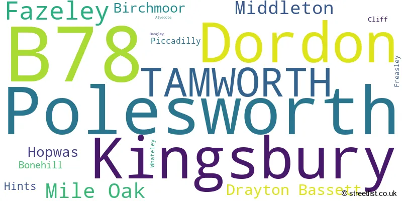
The largest settlement in the B78 postal code is Polesworth followed by TAMWORTH, and Kingsbury.
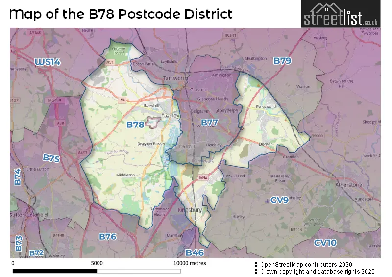
The B78 Postcode shares a border with B76 (SUTTON COLDFIELD, Minworth, Curdworth), B77 (TAMWORTH, Wilnecote, Amington), B46 (Coleshill, Water Orton), B79 (TAMWORTH, Warton, Elford), CV9 (ATHERSTONE, Grendon, Hurley) and WS14 (LICHFIELD, Shenstone, Whittington).
In the B78 postcode district, the primary settlement is Polesworth located in the county of Warwickshire. The post town for this district is Tamworth, also in the county of Warwickshire.
For the district B78, we have data on 3 postcode sectors. Here's a breakdown: The sector B78 1, covers Polesworth and Dordon in Warwickshire. The sector B78 2, covers Kingsbury and Middleton in Warwickshire. The sector B78 3, covers Tamworth and Fazeley and Mile Oak in Staffordshire.

Map of the B78 Postcode District
Explore the B78 postcode district by using our free interactive map.
When it comes to local government, postal geography often disregards political borders. However, for a breakdown in the B78 District: the district mostly encompasses the North Warwickshire District (B) (376 postcodes), followed by the Lichfield District area (176 postcodes), and finally, the Tamworth District (B) area (89 postcodes).
Weather Forecast for B78
Press Button to Show Forecast for Drayton Manor Park
| Time Period | Icon | Description | Temperature | Rain Probability | Wind |
|---|---|---|---|---|---|
| 06:00 to 09:00 | Cloudy | 4.0°C (feels like 2.0°C) | 4.00% | NE 4 mph | |
| 09:00 to 12:00 | Cloudy | 7.0°C (feels like 4.0°C) | 5.00% | ENE 7 mph | |
| 12:00 to 15:00 | Overcast | 9.0°C (feels like 8.0°C) | 10.00% | ENE 4 mph | |
| 15:00 to 18:00 | Cloudy | 10.0°C (feels like 9.0°C) | 8.00% | ENE 4 mph | |
| 18:00 to 21:00 | Cloudy | 9.0°C (feels like 8.0°C) | 10.00% | E 7 mph | |
| 21:00 to 00:00 | Partly cloudy (night) | 7.0°C (feels like 5.0°C) | 8.00% | ENE 7 mph |
Press Button to Show Forecast for Drayton Manor Park
| Time Period | Icon | Description | Temperature | Rain Probability | Wind |
|---|---|---|---|---|---|
| 00:00 to 03:00 | Cloudy | 5.0°C (feels like 3.0°C) | 12.00% | ENE 7 mph | |
| 03:00 to 06:00 | Cloudy | 4.0°C (feels like 2.0°C) | 12.00% | ENE 7 mph | |
| 06:00 to 09:00 | Cloudy | 5.0°C (feels like 2.0°C) | 13.00% | ENE 7 mph | |
| 09:00 to 12:00 | Cloudy | 7.0°C (feels like 5.0°C) | 17.00% | ENE 9 mph | |
| 12:00 to 15:00 | Overcast | 9.0°C (feels like 7.0°C) | 25.00% | ENE 9 mph | |
| 15:00 to 18:00 | Light rain | 10.0°C (feels like 8.0°C) | 49.00% | ENE 9 mph | |
| 18:00 to 21:00 | Cloudy | 10.0°C (feels like 7.0°C) | 19.00% | ENE 9 mph | |
| 21:00 to 00:00 | Cloudy | 8.0°C (feels like 5.0°C) | 21.00% | NE 9 mph |
Press Button to Show Forecast for Drayton Manor Park
| Time Period | Icon | Description | Temperature | Rain Probability | Wind |
|---|---|---|---|---|---|
| 00:00 to 03:00 | Light rain | 7.0°C (feels like 5.0°C) | 49.00% | NE 9 mph | |
| 03:00 to 06:00 | Light rain | 7.0°C (feels like 4.0°C) | 52.00% | NE 9 mph | |
| 06:00 to 09:00 | Heavy rain | 7.0°C (feels like 5.0°C) | 75.00% | NNE 9 mph | |
| 09:00 to 12:00 | Heavy rain | 9.0°C (feels like 7.0°C) | 76.00% | NNE 9 mph | |
| 12:00 to 15:00 | Light rain | 10.0°C (feels like 8.0°C) | 53.00% | NNW 9 mph | |
| 15:00 to 18:00 | Light rain | 11.0°C (feels like 9.0°C) | 54.00% | N 9 mph | |
| 18:00 to 21:00 | Heavy rain shower (day) | 11.0°C (feels like 9.0°C) | 56.00% | WSW 9 mph | |
| 21:00 to 00:00 | Partly cloudy (night) | 9.0°C (feels like 7.0°C) | 11.00% | SSW 7 mph |
Where is the B78 Postcode District?
The B78 postcode district is located in the town of Tamworth. It is close to several nearby towns, including Atherstone to the east (5.6 miles away), Sutton Coldfield to the southwest (5.9 miles away), Lichfield to the northwest (6.8 miles away), Nuneaton to the southeast (10.7 miles away), Walsall to the west (11.1 miles away), and Swadlincote to the northeast (11.9 miles away). Additionally, the distance from the B78 postcode district to the center of London is approximately 101.1 miles.
The district is within the post town of TAMWORTH.
The sector has postcodes within the nation of England.
The B78 Postcode District is covers the following regions.
- Warwickshire - Herefordshire, Worcestershire and Warwickshire - West Midlands (England)
- Staffordshire CC - Shropshire and Staffordshire - West Midlands (England)
| Postcode Sector | Delivery Office |
|---|---|
| B78 1 | Dordelivery Officen Scale Payment Delivery Office |
| B78 1 | Polesworth Scale Payment Delivery Office |
| B78 1 | Tamworth Delivery Office |
| B78 2 | Tamworth Delivery Office |
| B78 3 | Tamworth Delivery Office |
| B | 7 | 8 | - | X | X | X |
| B | 7 | 8 | Space | Numeric | Letter | Letter |
Tourist Attractions within the Postcode Area
We found 2 visitor attractions within the B78 postcode area
| Drayton Manor Theme Park |
|---|
| Leisure / Theme Parks |
| Leisure / Theme Park |
| View Drayton Manor Theme Park on Google Maps |
| Pooley Fields Heritage Centre |
| Country Parks |
| Country Park |
| View Pooley Fields Heritage Centre on Google Maps |
Current Monthly Rental Prices
| # Bedrooms | Min Price | Max Price | Avg Price |
|---|---|---|---|
| 1 | £485 | £560 | £523 |
| 2 | £725 | £1,450 | £924 |
| 3 | £850 | £1,700 | £1,170 |
| 4 | £1,250 | £2,995 | £2,065 |
| 5 | £2,500 | £2,500 | £2,500 |
Current House Prices
| # Bedrooms | Min Price | Max Price | Avg Price |
|---|---|---|---|
| 3 | £550,000 | £835,000 | £653,333 |
| 4 | £500,000 | £825,000 | £666,667 |
| 5 | £500,000 | £1,800,000 | £919,444 |
| 6 | £875,000 | £2,500,000 | £1,441,667 |
| 10 | £1,350,000 | £1,350,000 | £1,350,000 |
Estate Agents who Operate in the B78 District
| Logo | Name | Brand Name | Address | Contact Number | Total Properties |
|---|---|---|---|---|---|
 | Tamworth | Bairstow Eves | 83 - 84 Bolebridge Street, Tamworth, Staffordshire, B79 7PD | 020 3835 4131 | 18 |
 | Tamworth | Wilkins Estate Agents | 9 Bolebridge Street, Tamworth, B79 7PA | 01827 948521 | 17 |
 | Tamworth | Taylor Cole Estate Agents | 6a Victoria Road, Tamworth, B79 7HL | 01827 948614 | 17 |
 | Tamworth | Hunters | 6 Victoria Road Tamworth B79 7HL | 01822 667981 | 16 |
 | Tamworth | Mark Webster Estate Agents | 29 Bridge Street, Polesworth, Tamworth, Staffordshire, B78 1DR | 01827 214441 | 13 |
| Type of Property | 2018 Average | 2018 Sales | 2017 Average | 2017 Sales | 2016 Average | 2016 Sales | 2015 Average | 2015 Sales |
|---|---|---|---|---|---|---|---|---|
| Detached | £323,954 | 136 | £308,581 | 135 | £293,265 | 103 | £271,570 | 103 |
| Semi-Detached | £201,536 | 184 | £188,696 | 161 | £168,174 | 145 | £159,368 | 141 |
| Terraced | £158,856 | 91 | £151,246 | 111 | £146,282 | 115 | £143,838 | 82 |
| Flats | £132,423 | 20 | £144,380 | 23 | £117,495 | 22 | £104,129 | 19 |