The BD13 5 postcode sector is within the county of West Yorkshire.
Did you know? According to the 2021 Census, the BD13 5 postcode sector is home to a bustling 3,419 residents!
Given that each sector allows for 400 unique postcode combinations. Letters C, I, K, M, O and V are not allowed in the last two letters of a postcode. With 117 postcodes already in use, this leaves 283 units available.
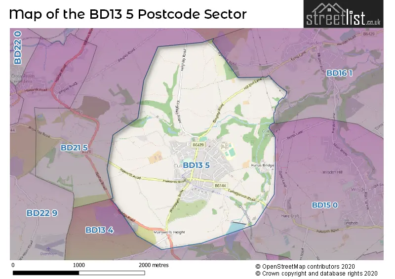
The BD13 5 postal code covers the settlement of Cullingworth.
The BD13 5 Postcode shares a border with BD15 0 (Wilsden), BD13 4 (Denholme), BD16 1 (BINGLEY, Harden, Cottingley) and BD21 5 (KEIGHLEY, Hainworth, Hainworth Shaw).
The sector is within the post town of BRADFORD.
BD13 5 is a postcode sector within the BD13 postcode district which is within the BD Bradford postcode area.
The Royal Mail delivery office for the BD13 5 postal sector is the West Bradford Delivery Office.
The area of the BD13 5 postcode sector is 2.37 square miles which is 6.13 square kilometres or 1,513.93 square acres.


Map of the BD13 5 Postcode Sector
Explore the BD13 5 postcode sector by using our free interactive map.
| B | D | 1 | 3 | - | 5 | X | X |
| B | D | 1 | 3 | Space | 5 | Letter | Letter |
Official List of Streets
Cullingworth (77 Streets)
Unofficial Streets or Alternative Spellings
Cullingworth
HALLAS BRIDGEWilsden
HAWORTH ROADHarden
HILL END LANEDenholme
TROUGH LANECross Roads
HALIFAX ROADSchools and Places of Education Within the BD13 5 Postcode Sector
Cullingworth Village Primary School
Academy converter
New School Lane, Bradford, West Yorkshire, BD13 5DA
Head: Mrs Cathy Isaac
Ofsted Rating: Good
Inspection: 2022-12-08 (544 days ago)
Website: Visit Cullingworth Village Primary School Website
Phone: 01535273839
Number of Pupils: 315
House Prices in the BD13 5 Postcode Sector
| Type of Property | 2018 Average | 2018 Sales | 2017 Average | 2017 Sales | 2016 Average | 2016 Sales | 2015 Average | 2015 Sales |
|---|---|---|---|---|---|---|---|---|
| Detached | £337,092 | 34 | £316,621 | 44 | £300,344 | 36 | £300,065 | 15 |
| Semi-Detached | £214,940 | 26 | £185,364 | 17 | £173,427 | 21 | £175,467 | 15 |
| Terraced | £121,439 | 41 | £148,265 | 36 | £147,251 | 34 | £159,070 | 35 |
| Flats | £142,090 | 5 | £151,000 | 1 | £77,500 | 2 | £118,250 | 2 |
Important Postcodes BD13 5 in the Postcode Sector
BD13 5AD is the postcode for Parkside School, Parkside Terrace, Cullingworth, and Parkside School, Parkside Terrace
BD13 5DA is the postcode for Cullingworth Primary School, New School Lane, Cullingworth, and Cullingworth Primary School, New School Lane
| The BD13 5 Sector is within these Local Authorities |
|
|---|---|
| The BD13 5 Sector is within these Counties |
|
| The BD13 5 Sector is within these Water Company Areas |
|