The BH20 4 postcode sector is within the county of Dorset.
Did you know? According to the 2021 Census, the BH20 4 postcode sector is home to a bustling 5,846 residents!
Given that each sector allows for 400 unique postcode combinations. Letters C, I, K, M, O and V are not allowed in the last two letters of a postcode. With 213 postcodes already in use, this leaves 187 units available.
The largest settlements in the BH20 4 postal code are WAREHAM and Northport.
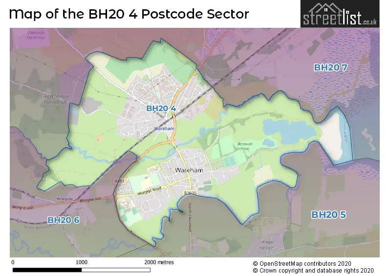
The BH20 4 Postcode shares a border with BH20 5 (Corfe Castle, WAREHAM, West Lulworth), BH20 6 (Wool, Bovington, East Stoke) and BH20 7 (Bere Regis, Sandford, WAREHAM).
The sector is within the post town of WAREHAM.
BH20 4 is a postcode sector within the BH20 postcode district which is within the BH Bournemouth postcode area.
The Royal Mail delivery office for the BH20 4 postal sector is the Wareham Delivery Office.
The area of the BH20 4 postcode sector is 2.49 square miles which is 6.45 square kilometres or 1,594.27 square acres.
Waterways within the BH20 4 postcode sector include the Frome, River Frome, River Piddle.

Map of the BH20 4 Postcode Sector
Explore the BH20 4 postcode sector by using our free interactive map.
| B | H | 2 | 0 | - | 4 | X | X |
| B | H | 2 | 0 | Space | 4 | Letter | Letter |
Official List of Streets
WAREHAM (103 Streets)
Northport (1 Streets)
Unofficial Streets or Alternative Spellings
WAREHAM
DALER COURT BONNETTS LANE CONNIGER LANE COOPERS CLOSE NORTH BRIDGE NORTH CAUSEWAY NORTHMOOR WAY CYCLE PATH NORTHPORT NORTHPORT GREENWAY PRESTON COURT SAINT MARYS CLOSE SANDFORD ROAD CYCLE PATH SAXON ROUNDABOUT SOUTH BRIDGE TANTINOBY LANE THE CROFT THE MEWS TRINITY CLOSE WAREHAM BYPASS WAREHAM QUAY WAREHAM WALLS WORGRET ROUNDABOUTSandford
SANDFORD ROADWeather Forecast for BH20 4
Press Button to Show Forecast for Wareham
| Time Period | Icon | Description | Temperature | Rain Probability | Wind |
|---|---|---|---|---|---|
| 09:00 to 12:00 | Partly cloudy (day) | 13.0°C (feels like 10.0°C) | 5.00% | SSE 13 mph | |
| 12:00 to 15:00 | Cloudy | 14.0°C (feels like 11.0°C) | 12.00% | SSE 13 mph | |
| 15:00 to 18:00 | Light rain shower (day) | 13.0°C (feels like 11.0°C) | 38.00% | SSE 11 mph | |
| 18:00 to 21:00 | Light rain | 12.0°C (feels like 10.0°C) | 52.00% | SSE 7 mph | |
| 21:00 to 00:00 | Cloudy | 10.0°C (feels like 9.0°C) | 20.00% | S 4 mph |
Press Button to Show Forecast for Wareham
| Time Period | Icon | Description | Temperature | Rain Probability | Wind |
|---|---|---|---|---|---|
| 00:00 to 03:00 | Cloudy | 9.0°C (feels like 8.0°C) | 9.00% | SSE 4 mph | |
| 03:00 to 06:00 | Cloudy | 9.0°C (feels like 8.0°C) | 6.00% | SSE 4 mph | |
| 06:00 to 09:00 | Cloudy | 10.0°C (feels like 9.0°C) | 8.00% | ESE 4 mph | |
| 09:00 to 12:00 | Cloudy | 12.0°C (feels like 11.0°C) | 9.00% | SSE 4 mph | |
| 12:00 to 15:00 | Cloudy | 13.0°C (feels like 13.0°C) | 16.00% | SSW 4 mph | |
| 15:00 to 18:00 | Cloudy | 14.0°C (feels like 13.0°C) | 19.00% | WSW 4 mph | |
| 18:00 to 21:00 | Light rain | 12.0°C (feels like 11.0°C) | 55.00% | WNW 7 mph | |
| 21:00 to 00:00 | Light rain | 11.0°C (feels like 9.0°C) | 49.00% | NW 9 mph |
Press Button to Show Forecast for Wareham
| Time Period | Icon | Description | Temperature | Rain Probability | Wind |
|---|---|---|---|---|---|
| 00:00 to 03:00 | Cloudy | 10.0°C (feels like 8.0°C) | 18.00% | NW 9 mph | |
| 03:00 to 06:00 | Light rain | 10.0°C (feels like 8.0°C) | 49.00% | NNW 9 mph | |
| 06:00 to 09:00 | Light rain | 10.0°C (feels like 8.0°C) | 49.00% | NNW 9 mph | |
| 09:00 to 12:00 | Cloudy | 13.0°C (feels like 11.0°C) | 18.00% | NNW 9 mph | |
| 12:00 to 15:00 | Overcast | 15.0°C (feels like 13.0°C) | 19.00% | NNW 9 mph | |
| 15:00 to 18:00 | Cloudy | 16.0°C (feels like 14.0°C) | 15.00% | NW 9 mph | |
| 18:00 to 21:00 | Cloudy | 15.0°C (feels like 14.0°C) | 17.00% | NW 9 mph | |
| 21:00 to 00:00 | Partly cloudy (night) | 12.0°C (feels like 11.0°C) | 9.00% | WNW 9 mph |
Schools and Places of Education Within the BH20 4 Postcode Sector
Wareham St Mary Church of England Primary School
Academy converter
Streche Road, Wareham, Dorset, BH20 4PG
Head: Mrs Nicole Davids
Ofsted Rating: Good
Inspection: 2022-05-12 (719 days ago)
Website: Visit Wareham St Mary Church of England Primary School Website
Phone: 01929552517
Number of Pupils: 182
House Prices in the BH20 4 Postcode Sector
| Type of Property | 2018 Average | 2018 Sales | 2017 Average | 2017 Sales | 2016 Average | 2016 Sales | 2015 Average | 2015 Sales |
|---|---|---|---|---|---|---|---|---|
| Detached | £394,804 | 23 | £441,507 | 45 | £387,213 | 41 | £459,468 | 49 |
| Semi-Detached | £293,455 | 22 | £311,526 | 17 | £295,030 | 33 | £257,952 | 31 |
| Terraced | £272,304 | 36 | £261,054 | 27 | £255,548 | 42 | £260,022 | 32 |
| Flats | £193,316 | 19 | £228,642 | 19 | £206,556 | 18 | £167,642 | 19 |
Important Postcodes BH20 4 in the Postcode Sector
BH20 4AA is the postcode for Units 4-5, Sandford Lane Industrial Estate
BH20 4DY is the postcode for Purbeck Opportunities Centre, Sandford Lane
BH20 4HB is the postcode for Anglebury Court EPH, 21 Bonnets Lane
BH20 4PF is the postcode for MAIN BUILDING, The Purbeck School, Worgret Road, and The Purbeck School, Worgret Road
BH20 4PG is the postcode for Wareham Lady St. Mary C of E First School, Streche Road, Wareham Health Centre, Streche Road, and Wareham Surgery, Streche Road
BH20 4PH is the postcode for Wareham Middle School, Worgret Road, and Purbeck Sports Centre, Worgret Road
BH20 4PL is the postcode for Dorset Fire & Rescue Service, Fire Station, Worgret Road
BH20 4PP is the postcode for Westport House, Worgret Road, and Dorset Council, Westport House, Worgret Road
BH20 4PW is the postcode for Dorset Police, Wareham Police Station, Worgret Road
BH20 4QQ is the postcode for Dorset PCT, Wareham Community Hospital, and Wareham Hospital, Streche Road
BH20 4SW is the postcode for Prospect House, 8 Westminster Road
| The BH20 4 Sector is within these Local Authorities |
|
|---|---|
| The BH20 4 Sector is within these Counties |
|
| The BH20 4 Sector is within these Water Company Areas |
|
Tourist Attractions within the BH20 4 Postcode Area
We found 1 visitor attractions within the BH20 postcode area
| Wareham Town Museum |
|---|
| Museums & Art Galleries |
| Museum and / or Art Gallery |
| View Wareham Town Museum on Google Maps |