The BH20 postcode district is a postal district located in the BH Bournemouth postcode area with a population of 20,325 residents according to the 2021 England and Wales Census.
The area of the BH20 postcode district is 102.50 square miles which is 265.47 square kilometres or 65,598.57 acres.
Currently, the BH20 district has about 718 postcode units spread across 4 geographic postcode sectors.
Given that each sector allows for 400 unique postcode combinations, the district has a capacity of 1,600 postcodes. With 718 postcodes already in use, this leaves 882 units available.
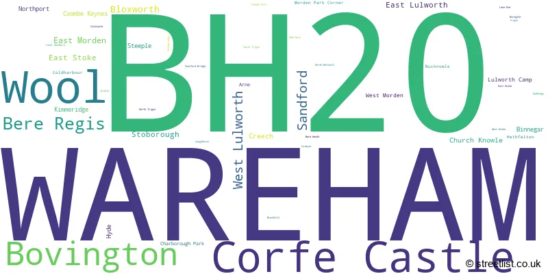
The largest settlement in the BH20 postal code is WAREHAM followed by Wool, and Corfe Castle.
The postcode area has a boundary with The English Channel and Poole Harbour.
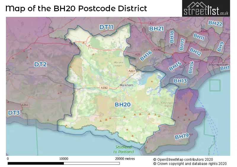
The BH20 Postcode shares a border with DT11 (BLANDFORD FORUM, Blandford St. Mary, Milborne St. Andrew), BH16 (POOLE, Lytchett Matravers, Upton), DT2 (Crossways, Charminster, Puddletown), BH19 (SWANAGE, Studland, Langton Matravers) and BH13 (POOLE, Branksome Park).
In the BH20 postcode district, the primary settlement with the highest count is Wareham. The other significant settlements in this district include North Bestwall, Northport, Arne, Bradle, Bucknowle, Burngate, Church Knowle, Cocknowle, Coombe Keynes, Corfe Castle, Creech, East Lulworth, Kimmeridge, Lulworth Camp, Steeple, Stoborough, West Lulworth, Binnegar, Bovington, East Holme, East Stoke, Hethfelton, Holmebridge, Longthorns, West Holme, Wool, Bere Heath, Bere Regis, Bloxworth, Brockhill, Charborough Park, Clouds Hill, Coldharbour, Culeaze, Doddings, East Morden, Hyde, Lane End, Lower Woodbury, Morden Park Corner, North Trigon, Sandford, Sherford, Snatford Bridge, South Trigon, and Trigon. The county in this district is the county of Dorset, located in England. The most significant post town in this district is Wareham.
For the district BH20, we have data on 5 postcode sectors. Here's a breakdown: The sector BH20 4, covers Wareham in Dorset. The sector BH20 5, covers Corfe Castle and West Lulworth and Wareham in Dorset. The sector BH20 6, covers Wool and Bovington in Dorset. The sector BH20 7, covers Bere Regis and Sandford and Wareham in Dorset. The sector BH20 9 is non-geographic. It's often designated for PO Boxes, large organisations, or special services.

Map of the BH20 Postcode District
Explore the BH20 postcode district by using our free interactive map.
When it comes to local government, postal geography often disregards political borders. However, for a breakdown in the BH20 District: the district mostly encompasses the Dorset area with a total of 717 postcodes.
Where is the BH20 Postcode District?
The postcode district BH20 is located in Wareham, a town in Dorset, England. It is situated near several towns in different directions. To the North East is Broadstone, which is approximately 8.3 miles away. To the South East is Swanage, which is approximately 8.3 miles away as well. To the East is Poole, which is around 9.9 miles away. To the North is Blandford Forum, which is approximately 11.8 miles away. To the West is Weymouth, which is approximately 14.6 miles away. The district is also about 104.6 miles away from the center of London.
The district is within the post town of WAREHAM.
The sector has postcodes within the nation of England.
The BH20 Postcode District is in the region of within the .
Weather Forecast for BH20
Press Button to Show Forecast for Wareham
| Time Period | Icon | Description | Temperature | Rain Probability | Wind |
|---|---|---|---|---|---|
| 09:00 to 12:00 | Cloudy | 17.0°C (feels like 15.0°C) | 3.00% | E 9 mph | |
| 12:00 to 15:00 | Partly cloudy (day) | 20.0°C (feels like 18.0°C) | 0.00% | ESE 9 mph | |
| 15:00 to 18:00 | Cloudy | 21.0°C (feels like 19.0°C) | 3.00% | ESE 11 mph | |
| 18:00 to 21:00 | Sunny day | 19.0°C (feels like 17.0°C) | 0.00% | ESE 7 mph | |
| 21:00 to 00:00 | Cloudy | 15.0°C (feels like 14.0°C) | 3.00% | E 7 mph |
Press Button to Show Forecast for Wareham
| Time Period | Icon | Description | Temperature | Rain Probability | Wind |
|---|---|---|---|---|---|
| 00:00 to 03:00 | Cloudy | 15.0°C (feels like 14.0°C) | 3.00% | E 9 mph | |
| 03:00 to 06:00 | Cloudy | 14.0°C (feels like 13.0°C) | 3.00% | ENE 7 mph | |
| 06:00 to 09:00 | Cloudy | 15.0°C (feels like 14.0°C) | 4.00% | ENE 7 mph | |
| 09:00 to 12:00 | Partly cloudy (day) | 18.0°C (feels like 17.0°C) | 1.00% | ESE 9 mph | |
| 12:00 to 15:00 | Partly cloudy (day) | 20.0°C (feels like 19.0°C) | 3.00% | SE 9 mph | |
| 15:00 to 18:00 | Cloudy | 19.0°C (feels like 18.0°C) | 5.00% | S 7 mph | |
| 18:00 to 21:00 | Cloudy | 16.0°C (feels like 14.0°C) | 5.00% | SSW 9 mph | |
| 21:00 to 00:00 | Cloudy | 13.0°C (feels like 12.0°C) | 5.00% | SSW 7 mph |
Press Button to Show Forecast for Wareham
| Time Period | Icon | Description | Temperature | Rain Probability | Wind |
|---|---|---|---|---|---|
| 00:00 to 03:00 | Partly cloudy (night) | 12.0°C (feels like 12.0°C) | 4.00% | SW 7 mph | |
| 03:00 to 06:00 | Overcast | 13.0°C (feels like 11.0°C) | 13.00% | SW 9 mph | |
| 06:00 to 09:00 | Overcast | 13.0°C (feels like 11.0°C) | 17.00% | S 11 mph | |
| 09:00 to 12:00 | Light rain | 14.0°C (feels like 11.0°C) | 52.00% | S 16 mph | |
| 12:00 to 15:00 | Light rain shower (day) | 15.0°C (feels like 12.0°C) | 49.00% | SSE 16 mph | |
| 15:00 to 18:00 | Heavy rain | 14.0°C (feels like 12.0°C) | 92.00% | SSE 16 mph | |
| 18:00 to 21:00 | Heavy rain | 14.0°C (feels like 11.0°C) | 92.00% | S 16 mph | |
| 21:00 to 00:00 | Heavy rain | 13.0°C (feels like 11.0°C) | 87.00% | SSW 11 mph |
Press Button to Show Forecast for Wareham
| Time Period | Icon | Description | Temperature | Rain Probability | Wind |
|---|---|---|---|---|---|
| 00:00 to 03:00 | Light rain shower (night) | 12.0°C (feels like 11.0°C) | 45.00% | S 9 mph | |
| 03:00 to 06:00 | Partly cloudy (night) | 12.0°C (feels like 10.0°C) | 14.00% | S 9 mph | |
| 06:00 to 09:00 | Cloudy | 12.0°C (feels like 10.0°C) | 13.00% | S 13 mph | |
| 09:00 to 12:00 | Light rain shower (day) | 14.0°C (feels like 11.0°C) | 38.00% | S 16 mph | |
| 12:00 to 15:00 | Light rain shower (day) | 14.0°C (feels like 11.0°C) | 38.00% | S 18 mph | |
| 15:00 to 18:00 | Light rain shower (day) | 15.0°C (feels like 12.0°C) | 41.00% | S 16 mph | |
| 18:00 to 21:00 | Light rain shower (day) | 14.0°C (feels like 11.0°C) | 37.00% | S 13 mph | |
| 21:00 to 00:00 | Partly cloudy (night) | 12.0°C (feels like 10.0°C) | 8.00% | S 11 mph |
Press Button to Show Forecast for Wareham
| Time Period | Icon | Description | Temperature | Rain Probability | Wind |
|---|---|---|---|---|---|
| 00:00 to 03:00 | Partly cloudy (night) | 12.0°C (feels like 9.0°C) | 7.00% | S 11 mph | |
| 03:00 to 06:00 | Partly cloudy (night) | 11.0°C (feels like 9.0°C) | 8.00% | S 11 mph | |
| 06:00 to 09:00 | Cloudy | 12.0°C (feels like 10.0°C) | 15.00% | S 13 mph | |
| 09:00 to 12:00 | Light rain shower (day) | 13.0°C (feels like 11.0°C) | 37.00% | S 13 mph | |
| 12:00 to 15:00 | Light rain shower (day) | 14.0°C (feels like 12.0°C) | 38.00% | S 16 mph | |
| 15:00 to 18:00 | Light rain shower (day) | 14.0°C (feels like 12.0°C) | 36.00% | S 13 mph | |
| 18:00 to 21:00 | Light rain shower (day) | 13.0°C (feels like 11.0°C) | 31.00% | SSW 11 mph | |
| 21:00 to 00:00 | Partly cloudy (night) | 11.0°C (feels like 10.0°C) | 4.00% | S 9 mph |
| Postcode Sector | Delivery Office |
|---|---|
| BH20 4 | Wareham Delivery Office |
| BH20 5 | Wareham Delivery Office |
| BH20 5 | Corfe Castle Scale Payment Delivery Office |
| BH20 6 | Wareham Delivery Office |
| BH20 6 | Wool Scale Payment Delivery Office |
| BH20 7 | Wareham Delivery Office |
| B | H | 2 | 0 | - | X | X | X |
| B | H | 2 | 0 | Space | Numeric | Letter | Letter |
Tourist Attractions within the BH20 Postcode Area
We found 3 visitor attractions within the BH20 postcode area
| The Tank Museum |
|---|
| Museums & Art Galleries |
| Museum and / or Art Gallery |
| View The Tank Museum on Google Maps |
| Wareham Town Museum |
| Museums & Art Galleries |
| Museum and / or Art Gallery |
| View Wareham Town Museum on Google Maps |
| Corfe Castle |
| Historic Properties |
| Castle / Fort |
| View Corfe Castle on Google Maps |
Current Monthly Rental Prices
| # Bedrooms | Min Price | Max Price | Avg Price |
|---|---|---|---|
| 1 | £1,185 | £1,185 | £1,185 |
| 2 | £925 | £925 | £925 |
| 3 | £1,100 | £1,100 | £1,100 |
| 4 | £1,900 | £1,900 | £1,900 |
| 5 | £2,700 | £2,700 | £2,700 |
| 6 | £3,400 | £3,400 | £3,400 |
Current House Prices
| # Bedrooms | Min Price | Max Price | Avg Price |
|---|---|---|---|
| 3 | £825,000 | £1,000,000 | £916,667 |
| 4 | £820,000 | £2,000,000 | £1,109,000 |
| 5 | £845,000 | £1,750,000 | £1,213,000 |
| 6 | £875,000 | £2,695,000 | £1,785,000 |
| 7 | £950,000 | £950,000 | £950,000 |
| 12 | £1,500,000 | £1,500,000 | £1,500,000 |
Estate Agents who Operate in the BH20 District
| Logo | Name | Brand Name | Address | Contact Number | Total Properties |
|---|---|---|---|---|---|
 | Wareham | Purbeck Property | 5 South Street, Wareham, BH20 4LR | 01929 556660 | 32 |
 | Wareham | Goadsby | 10 West Street, Wareham, BH20 4JX | 01929 501362 | 32 |
 | Wareham | Albury & Hall(wareham) Ltd | 10 North Street, Wareham, BH20 4AF | 01904 935124 | 29 |
 | Wareham | DOMVS | 8 South Street, Wareham, BH20 4LT | 01929 501119 | 21 |
 | Wareham | Meyers Estate Agents | Burngate Cottage Duck Street Wool Wareham Dorest BH20 6DE | 01929 503105 | 20 |
- Bere Regis
- Binnegar
- Bloxworth
- Bovington Camp
- Briantspuddle
- Church Knowle
- Coombe Keynes
- Corfe Castle
- Creech
- East Lulworth
- East Morden
- East Stoke
- Furzebrook
- Harman's Cross
- Holton Heath
- Kingston
- Lane End
- Little Woolgarston
- Lulworth Cove
- Lytchett Matravers
- Norden
- Poole
- Ridge
- Sandford
- Shitterton
- Slepe
- Stoborough Green
- Stoborough Heath
- Stoborough
- Swanage
- Wareham
- West Lulworth
- Whitefield
- Winterborne Kingston
- Winterborne Zelston
- Wool
- Worgret
- Worth Matravers
Yearly House Price Averages for the BH20 Postcode District
| Type of Property | 2018 Average | 2018 Sales | 2017 Average | 2017 Sales | 2016 Average | 2016 Sales | 2015 Average | 2015 Sales |
|---|---|---|---|---|---|---|---|---|
| Detached | £441,536 | 112 | £461,624 | 146 | £420,848 | 137 | £435,936 | 149 |
| Semi-Detached | £301,091 | 74 | £298,547 | 64 | £272,253 | 83 | £255,475 | 73 |
| Terraced | £273,146 | 80 | £254,971 | 72 | £248,993 | 76 | £237,908 | 75 |
| Flats | £190,177 | 31 | £207,757 | 30 | £183,000 | 27 | £163,607 | 30 |